A sea ice type remote sensing classification method based on convolution neural network

A technology of convolutional neural network and classification method, applied in instrument, character and pattern recognition, scene recognition, etc., can solve the problems of high cost of SAR image acquisition, difficulty in large-scale sea ice classification, and small spatial coverage of remote sensing images, etc. problem, achieve the effect of simple and easy execution steps, improve classification efficiency, and reduce manual participation

Inactive Publication Date: 2019-02-19
NANJING UNIV
View PDF4 Cites 6 Cited by
  • Summary
  • Abstract
  • Description
  • Claims
  • Application Information

AI Technical Summary

Problems solved by technology

Early sea ice type data can only be obtained through manual field surveys. Later, optical and SAR remote sensing images can be used to classify sea ice. However, due to the small space coverage of remote sensing images, optical images are greatly affected by light and clouds. Difficult constraints such as relatively high costs make it difficult to achieve large-scale sea ice classification

Method used


Image

  • A sea ice type remote sensing classification method based on convolution neural network
  • A sea ice type remote sensing classification method based on convolution neural network
  • A sea ice type remote sensing classification method based on convolution neural network

Examples


Embodiment Construction

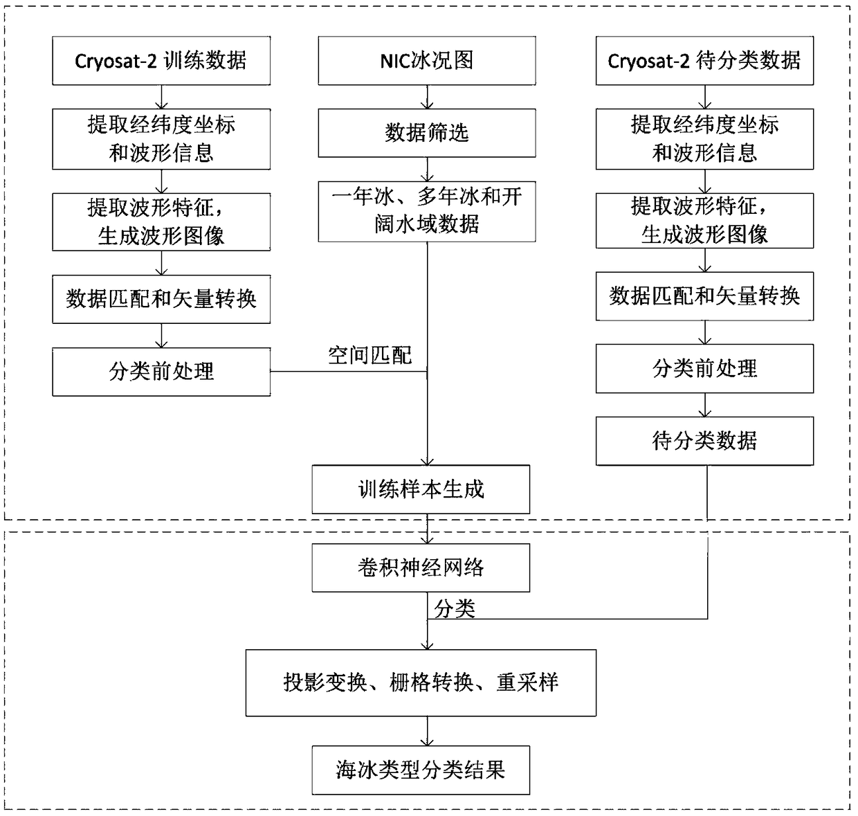
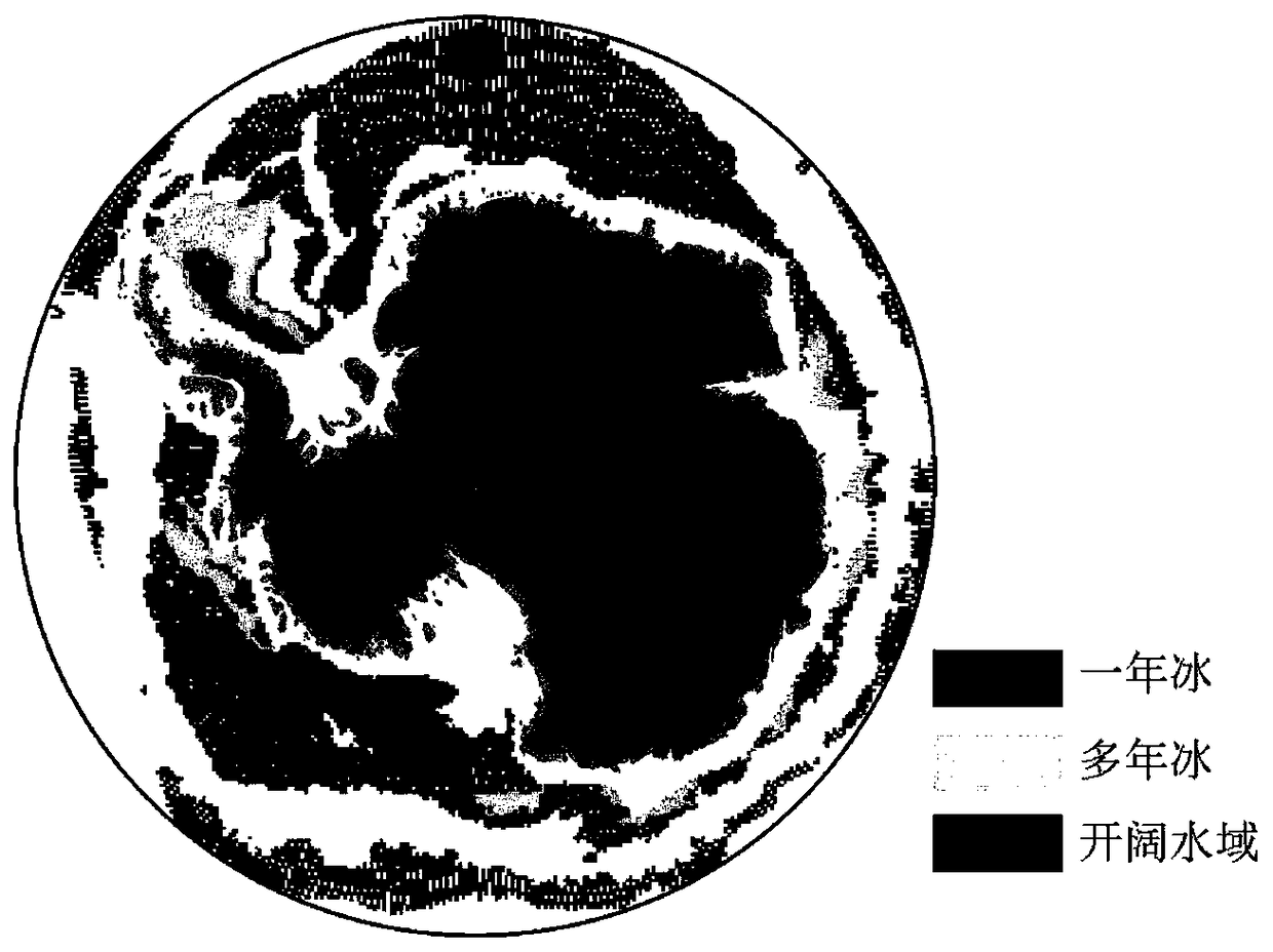
[0026] The present invention will be described in detail below according to the accompanying drawings, so as to make the technical route and operation steps of the present invention clearer. The data used in the examples of the present invention are the CryoSat-2 satellite L1b level SAR model baseline C data and NIC shapfile format data. The sample data was acquired from September 1, 2017 to September 30, 2017, and the NIC sea ice type data was acquired from September 14, 2017.

[0027] figure 1 It is a flowchart of sea ice remote sensing classification method based on convolutional neural network, and the specific steps are as follows:

[0028] Step 1: Prepare training data and data to be classified, and read information from the data. Specifically, it includes the following aspects:

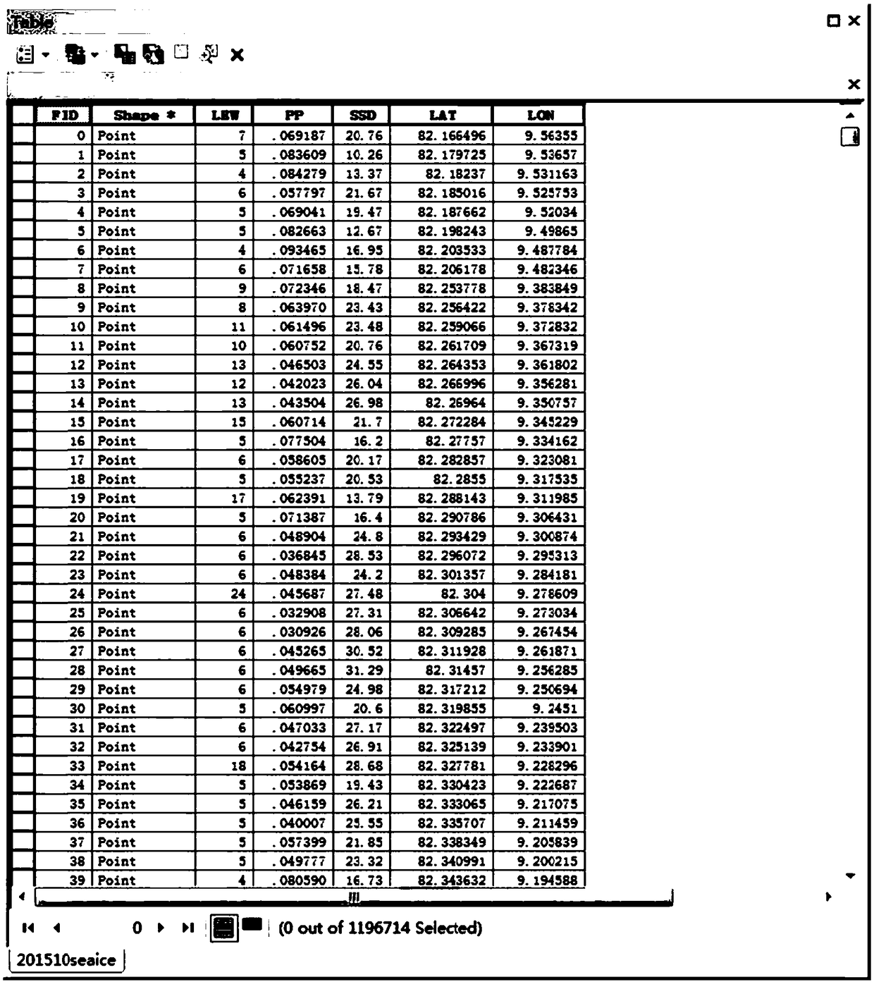
[0029] a. Download the CryoSat-2 satellite SAR mode L1b level data in a certain period, and obtain sample data (September 1, 2017-September 30, 2017), randomly according to the ratio of trai...


PUM


Abstract

The invention discloses a sea ice type remote sensing classification method based on a convolution neural network, and belongs to the field of remote sensing geoscience application technology. The method uses satellite radar altimeter data to classify sea ice (divided into multi-year ice, one-year ice and open water). The steps include obtaining longitude and latitude coordinates of measurement points from altimeter data and radar echo waveform; downloading the sea ice type data and extracting the sea ice type information at the corresponding measurement point. The extracted data information is spatially matched and converted into vector point data with longitude and latitude coordinates. The radar echo waveform and the corresponding sea ice type are used as training data to train the convolution neural network, and the radar echo waveform to be classified is used to identify the sea ice type. After classification, the sea ice types are marked on the vector data. The tagged vector dataare processed by projection transformation, raster transformation and spatial resampling to obtain the sea ice type of the whole study area.

Description

technical field [0001] The invention relates to a sea ice type remote sensing classification method based on a convolutional neural network, belonging to the technical field of remote sensing applications. technical background [0002] Changes in sea ice type are an important indicator of climate change, with changes affecting sea ice thickness inversions, ship routing, and other important human polar activities. Early sea ice type data can only be obtained through manual field surveys. Later, optical and SAR remote sensing images can be used to classify sea ice. However, due to the small space coverage of remote sensing images, optical images are greatly affected by light and clouds. Due to the relatively high cost and other difficult constraints, it is difficult to achieve large-scale sea ice classification. With the development of satellite radar altimeters, altimeter data can be used to classify sea ice. Although altimeters are often used to retrieve the thickness of s...

Claims


Application Information

Patent Timeline
Patent Type & Authority Applications(China)
IPC IPC(8): G06K9/00G06K9/62G06F16/29
CPCG06V20/13G06F18/24G06F18/214
Inventor 柯长青沈校熠李萌萌蔡宇李海丽
Owner NANJING UNIV
Why Eureka
Try Eureka