A task scheduling method based on prospective prediction

A task scheduling and task technology, applied in the direction of instruments, data processing applications, resources, etc., can solve the problem of the sharp increase of satellite storage capacity, and achieve the effect of improving utilization and reducing storage capacity.

Active Publication Date: 2019-02-22
SPACETY CO LTD (CHANGSHA)
View PDF9 Cites 6 Cited by
  • Summary
  • Abstract
  • Description
  • Claims
  • Application Information

AI Technical Summary

Problems solved by technology

This invention does not involve the problem of how to match the imaging time and imaging data download time so that the

Method used


Image

  • A task scheduling method based on prospective prediction
  • A task scheduling method based on prospective prediction
  • A task scheduling method based on prospective prediction

Examples


Example Embodiment

[0026] Example 1

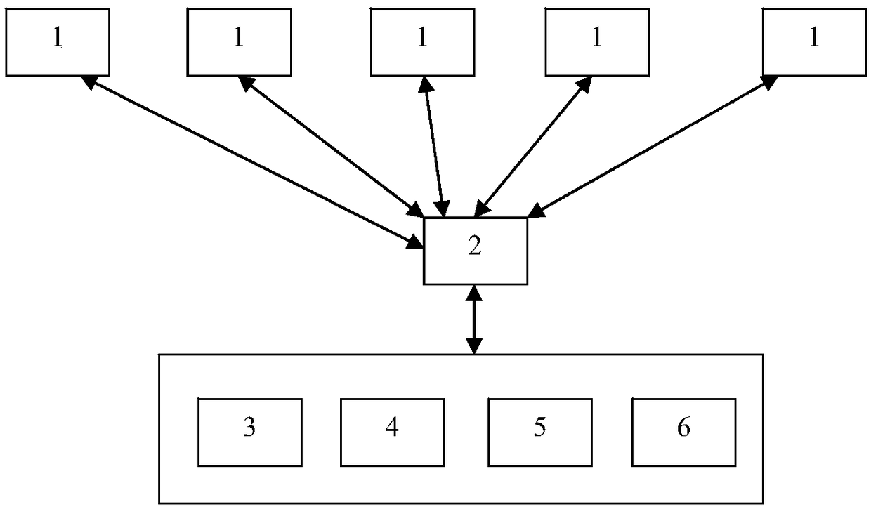
[0027] Such as figure 1 As shown, the present invention discloses a task scheduling system and method based on forward prediction, which at least includes a remote sensing satellite 1 and a ground station 2 communicating with each other. The remote sensing satellites can be several satellites distributed on different orbits for performing image acquisition tasks. The ground station is used to establish data communication with the remote sensing satellite, so that the control command of the ground station can be transmitted to the remote sensing satellite when the remote sensing satellite enters the communication coverage area of ​​the ground station, and at the same time, the image data collected by the remote sensing satellite can also be downloaded at this time To the ground station. The number of ground stations can be flexibly set according to actual usage requirements. For example, when the number of remote sensing satellites is increased in order to obt...

Example Embodiment

[0043] Example 2

[0044] This embodiment is a further improvement of Embodiment 1, and the repeated content will not be repeated.

[0045] Preferably, the task scheduling module also completes the remote sensing satellite scheduling by establishing a scheduling instruction at least according to the following steps:

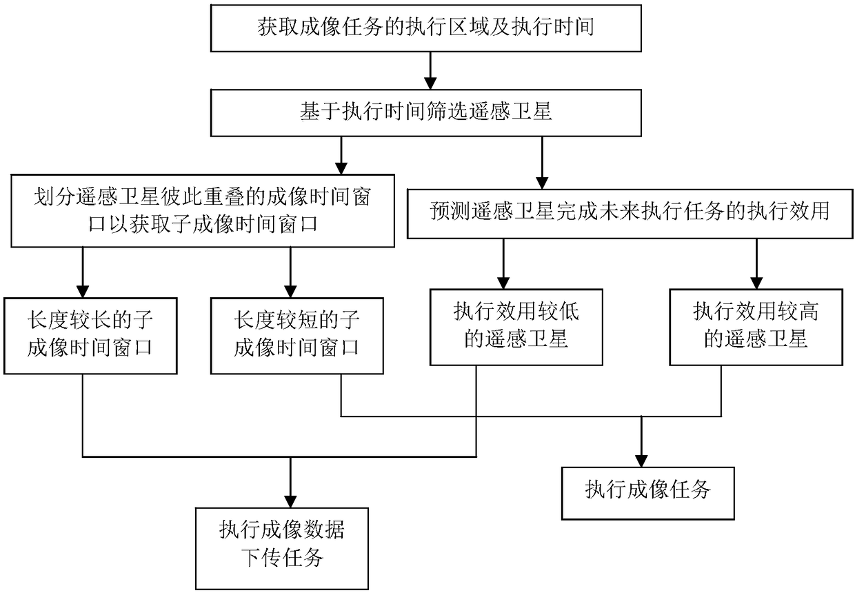
[0046] S1: Preliminarily classify imaging tasks based on the associated execution area information, imaging satellites, and imaging window time to establish an imaging task set that requires at least two remote sensing satellites 1 to complete cooperatively.

[0047] Preferably, the central processing module 6 is also configured to preliminarily classify the corresponding imaging tasks based on the real-time task demand data of the third party. Imaging tasks can be classified into the first type, the second type and the third type. The imaging tasks belonging to the first type are those that cannot be completed without proper satellite resources or due to other constrain...

Example Embodiment

[0058] Example 3

[0059] This embodiment is a further improvement of the foregoing embodiment, and the repeated content will not be repeated.

[0060] Preferably, the task scheduling module also completes the remote sensing satellite scheduling by establishing a scheduling instruction at least according to the following steps:

[0061] S1: Obtain the start execution time and the end execution time of the imaging task that requires at least two remote sensing satellites 1 to complete cooperatively, and filter out at least one first remote sensing satellite and at least one first remote sensing satellite whose imaging time window contains the start execution time and the end execution time respectively Two remote sensing satellites, if the combination of the imaging time windows of the first remote sensing satellite and the second remote sensing satellite cannot fully cover the execution time of the imaging mission, at least one third remote sensing satellite is selected.

[0062] Pref...


PUM


Abstract

The invention relates to a task scheduling method based on prospective prediction. Earth stations generate scheduling instructions as follows: determining at least an imaging time window in which thefirst remote sensing satellite and the second remote sensing satellite overlap each other and dividing the overlapping imaging time window into at least two sub-imaging time windows different in length from each other in the case where the current imaging task requires at least two remote sensing satellites to be accomplished in cooperation; obtaining an execution utility of at least one future execution task of each of the first remote sensing satellite and the second remote sensing satellite with respect to a current imaging task, wherein the first remote sensing satellite and the second remote sensing satellite generate the scheduling instruction in such a manner that imaging tasks and imaging data downloading tasks are alternately performed based on a sub-imaging time window. The invention sets each remote sensing satellite to execute imaging tasks and data downloading tasks in an alternating manner, and can effectively reduce the sharp increase in storage capacity of the remote sensing satellite by improving the speed of data turnover.

Description

technical field [0001] The invention relates to the technical field of scheduling control, in particular to a task scheduling method based on forward-looking prediction. Background technique [0002] The working process of imaging satellites can be briefly described as follows: receiving the observation requirements put forward by users; according to the characteristics of satellite resources, preprocessing the user's requirements to obtain standard planning input; combined with the constraints of the use of ground stations and satellites, according to specific optimization algorithms, Plan and schedule the input tasks to obtain the task scheduling scheme; plan and arrange the generated task scheduling scheme and generate instructions, inject the control instructions to the satellite through the ground station, the satellite executes the instruction for imaging and data playback, and the ground station receives the imaging Data, the data is processed and fed back to the user...

Claims


Application Information

Patent Timeline
IPC IPC(8): G06Q10/06
CPCG06Q10/06312
Inventor 任维佳杨峰杜志贵向晓霞
Owner SPACETY CO LTD (CHANGSHA)
Why Eureka
Try Eureka