Unmanned survey ship for shallow-water operation

A technology for measuring ships and shallow waters, which is applied in special-purpose ships, ship construction, ship propulsion, etc. It can solve problems such as low efficiency, easy rollover of inflatable ships, and inability to measure large-scale waters, so as to facilitate transportation and ensure stable support. sexual effect

Active Publication Date: 2019-03-01
黄志行
View PDF6 Cites 5 Cited by
  • Summary
  • Abstract
  • Description
  • Claims
  • Application Information

AI Technical Summary

Problems solved by technology

At present, when conducting geoinformation surveys, large-scale survey ships are generally used for survey operations, but for shallow water areas, survey ships cannot approach, and large areas will be missed. For geoinformation surveys in smooth shallow water areas, RTK is used to measure underwater Three-dimensional coordinates, the efficiency is low, and it is not suitable for large-scale water measurement. For areas with relatively fast water flow, inflatable boats are used, and the inflatable boats are easy to roll over during operation. This is the shortcoming of the existing technology.

Method used


Image

  • Unmanned survey ship for shallow-water operation
  • Unmanned survey ship for shallow-water operation
  • Unmanned survey ship for shallow-water operation

Examples


Embodiment Construction

[0024] In order to clearly illustrate the technical characteristics of this solution, the following will describe this solution through specific implementation modes and in conjunction with the accompanying drawings.

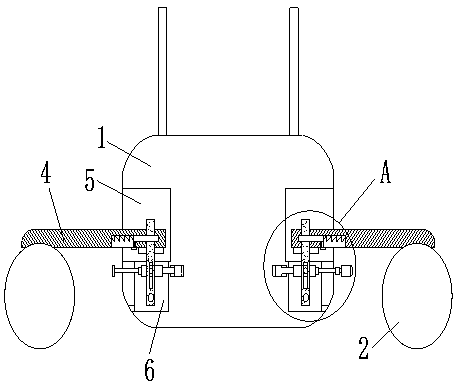
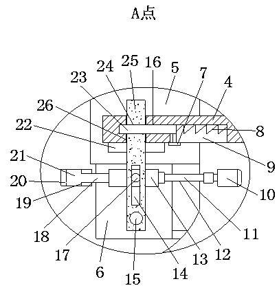
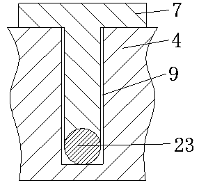
[0025] An unmanned survey ship for shallow water operations, as shown in the figure, it includes a hull 1 and buoys 2 located on both sides of the hull 1, and various measuring equipment are placed on the hull 1. The two sides of the hull 1 are symmetrically provided with installation slots A5, and the lower side of the installation slot A5 is provided with installation blind holes 6. The upper end of the buoy 2 is fixedly connected to one end of the support link 4, and the other end of the support link 4 extends into the corresponding installation groove A5, and a support column 25 is arranged in the installation blind hole 6 and the installation groove A5 , the bottom of the support column 25 is hinged to the bottom surface of the installation blind hole 6, an...


PUM


Abstract

The invention provides an unmanned survey ship for shallow-water operation. Mounting grooves A are formed at two side surfaces of a hull; mounting blind holes are formed at the lower side surfaces ofthe mounting grooves A; the upper end of each buoy is fixedly connected to one end of a corresponding supporting connecting rod; the other end of each of the supporting connecting rods extends into the corresponding mounting groove A; supporting columns are arranged inside the mounting blind holes and the mounting grooves A; the bottoms of the supporting columns are hinged to the bottom surfaces of the mounting blind holes; horizontal driving rods are arranged at the upper half parts of the mounting blind holes; the outside ends of the horizontal driving rods are rotationally connected with horizontal lead screws; the inside ends of the horizontal driving rods are fixedly connected with horizontal guiding rods; horizontal guiding holes are arranged at the side walls of the mounting blind holes; one end of each of the horizontal lead screws extends out of the side wall of the corresponding mounting blind hole and is driven by a corresponding servo motor; the outside surfaces of the horizontal driving rods are fixedly connected with horizontal shafts; strip-shaped through holes are arranged in the middle parts of the supporting columns; and the outer sides of the upper half parts ofthe supporting columns are fixed with position-limiting platforms. The survey ship can achieve stable traveling in shallow-water areas, and ensure high efficiency and stability of the survey operation.

Description

technical field [0001] The invention relates to an unmanned survey ship for shallow water operations, and belongs to the technical field of watering survey tools. Background technique [0002] Geographical information is the geographical meaning contained and expressed by geographic data, and it is a general term for numbers, texts, images, and graphics related to the quantity, quality, nature, distribution characteristics, connections, and laws of substances related to geographic environment elements. Geographic information is distinguished from conventionally defined spatial information. With the development of modern science and technology, especially with the help of modern mathematics, space science and computer science, people have been able to quickly collect geometric information, physical information and humanistic information of geographic space, and identify, convert, store, Transmit, display and apply this information to make it further serve human beings. At p...

Claims


Application Information

Patent Timeline
Patent Type & Authority Applications(China)
IPC IPC(8): B63B35/00B63B43/14B63H11/01B63H11/02
CPCB63B35/00B63B43/14B63H11/01B63H11/02
Inventor 黄志行
Owner 黄志行
Why Eureka
Try Eureka