Auxiliary ground robot navigation method and device based on unmanned aerial vehicle vision SLAM

A navigation method and technology of a navigation device, applied in the field of robotics, can solve the problems of limited mapping area, insufficiently precise mapping, high cost and so on

Active Publication Date: 2019-03-12
湖北三体星空文化服务有限公司
View PDF8 Cites 9 Cited by
  • Summary
  • Abstract
  • Description
  • Claims
  • Application Information

AI Technical Summary

Problems solved by technology

However, there are many problems in this scheme, including less laser data information, limited mapping area, low mapping efficiency, slow speed, insufficient mapping and high cost of mapping.

Method used


Image

  • Auxiliary ground robot navigation method and device based on unmanned aerial vehicle vision SLAM
  • Auxiliary ground robot navigation method and device based on unmanned aerial vehicle vision SLAM

Examples


Embodiment Construction

[0038] In order to clearly illustrate the solutions in the present invention, preferred embodiments are given below and detailed descriptions are given in conjunction with the accompanying drawings. The following description is merely exemplary in nature and is not intended to limit the application or uses of the present disclosure. It should be understood that throughout the drawings, corresponding reference numerals indicate like or corresponding parts and features.

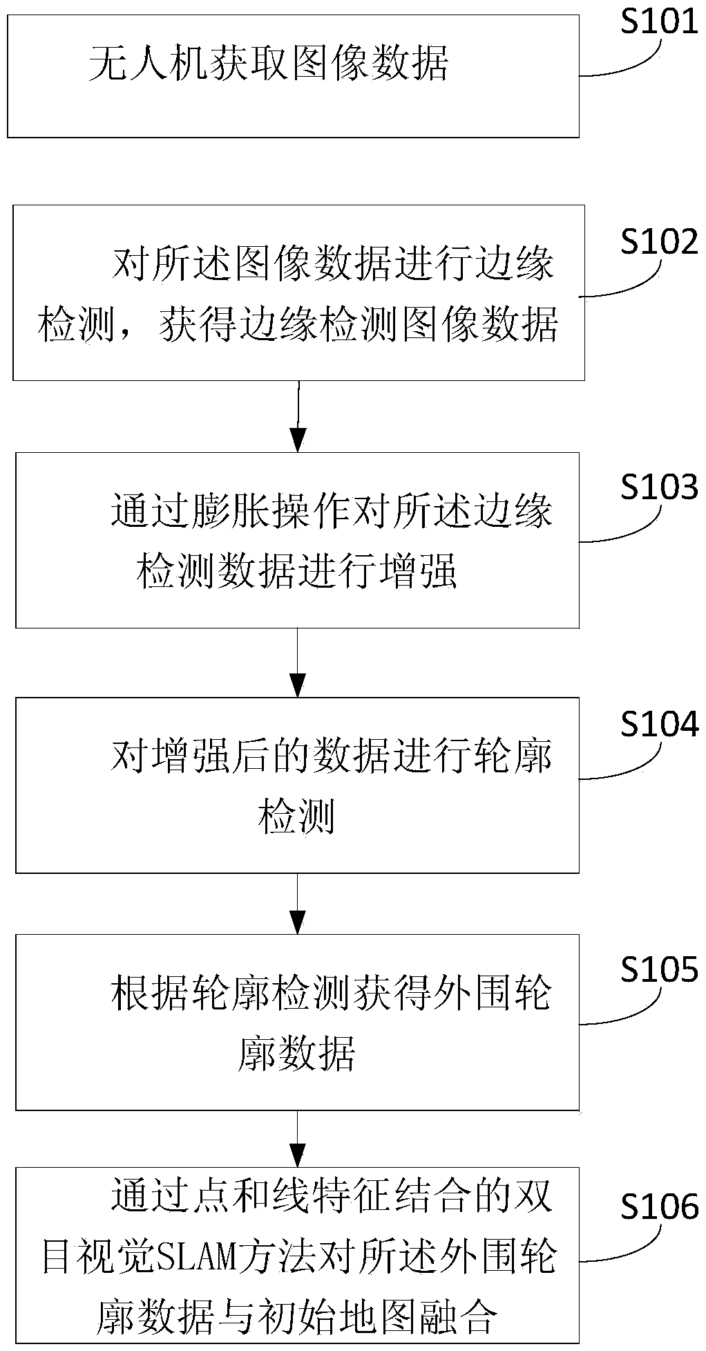
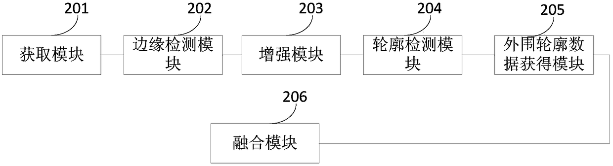
[0039] Such as figure 1 shown. A method for assisting ground robot navigation based on unmanned aerial vehicle visual SLAM, the method comprising:

[0040] S101, the UAV acquires image data;

[0041] S102. Perform edge detection on the image data to obtain edge detection image data; the edge detection is edge detection through a Canny operator.

[0042] The Canny operator is a kind of edge detection operator, which detects the edge of the object in the image, and the edge is the part of the local area of ​​...


PUM


Abstract

The invention discloses an auxiliary ground robot navigation method based on an unmanned aerial vehicle vision SLAM. The method comprises the following steps: acquiring image data by an unmanned aerial vehicle; performing edge detection on the image data, to obtain edge detection image data; through expansive operation, reinforcing the edge detection image data; performing contour detection on thereinforced data; according to the contour detection, acquiring peripheral contour data; and through a binocular vision SLAM method combined with point and line characteristics, fusing the peripheralcontour data and an initial map. The method is capable of solving problems that a laser data information quantity is less, a cartographic area is limited, charting efficiency is low, a speed is slow,charting is not elaborated enough and cost and investment of charting are large and the like.

Description

technical field [0001] The invention relates to the field of robots, in particular to a method and device for assisting ground robot navigation based on unmanned aerial vehicle visual SLAM. Background technique [0002] Simultaneous Localization And Mapping (SLAM) has always been the core technology and difficulty in the fields of intelligent robots, autonomous driving, and AR / VR. For ground robots, the most important thing to achieve autonomous navigation is to obtain a map of the surrounding environment. The current common ground robot mapping scheme mainly uses laser SLAM to map a single ground robot, but this scheme is artificially controlled. The area is limited, and the drawing efficiency is low, the speed is slow, and the drawing is not fine enough due to the low viewing angle of the ground laser, and the high cost of the laser makes the drawing expensive. [0003] Laser SLAM: Laser SLAM was born out of early ranging-based positioning methods (such as ultrasonic and ...

Claims


Application Information

Patent Timeline
Patent Type & Authority Applications(China)
IPC IPC(8): G01C21/20
CPCG01C21/20
Inventor 王晨捷罗斌尹露赵青王伟陈勇邹建成李露李成源
Owner 湖北三体星空文化服务有限公司
Why Eureka
Try Eureka