Functional area identification method based on remote sensing image and

A technology of remote sensing images and functional areas, applied in character and pattern recognition, instruments, calculations, etc., can solve the problems of large density gap of function points, low accuracy of social attribute features, and recognition accuracy of functional areas in affected areas, etc.

Inactive Publication Date: 2019-03-22
INST OF URBAN ENVIRONMENT CHINESE ACAD OF SCI
View PDF6 Cites 19 Cited by
  • Summary
  • Abstract
  • Description
  • Claims
  • Application Information

AI Technical Summary

Problems solved by technology

[0003] At present, in urban research based on remote sensing images, TM images are used to study large-scale urban expansion. In urban interiors, high-resolution remote sensing images are used to analyze non-built-up areas and their dynamic changes. The attributes of buildings such as services are difficult to determine from remote sensing images, so the accuracy of remote sensing images to identify objects with social attributes is low; there are relatively few applications and analyzes of POI data. Currently, the main methods used in the research of urban built-up areas are Calculate the density of points within the road buffer zone, and study the distribution characteristics of urban functional areas along the road direction
The method based on point density has certain shortcomings. Due to the large gap between different types of function point densities, in the process of constructing the function weight index system, it is difficult to determine a unified standard for each type of function weight, which affects the accuracy of functional area identification.

Method used


Image

  • Functional area identification method based on remote sensing image and
  • Functional area identification method based on remote sensing image and
  • Functional area identification method based on remote sensing image and

Examples


Embodiment Construction

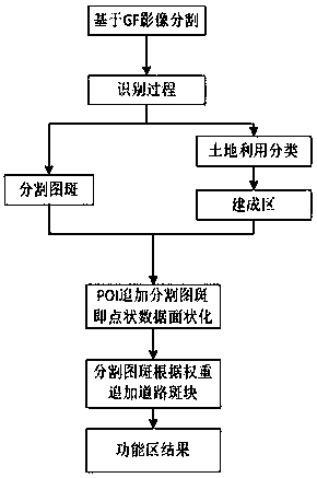
[0031] A method for identifying functional areas based on remote sensing images and network POI data of the present invention can be illustrated by the following embodiments:

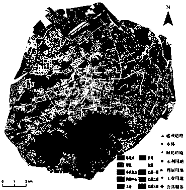
[0032] A. Select Xiamen Island as the research case area, and obtain Gaofen-2 remote sensing images and network POI data.

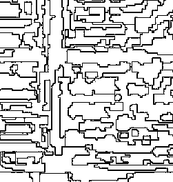
[0033] B. Based on the ENVI remote sensing image processing platform, segmentation is performed based on the Gaofen 2 data, and the segment only feature extraction in ENVI is used to segment the image. The parameter values ​​of segmentation and merging are 50 and 90 respectively, and the building is obtained. Segment the map of the basic unit, export the vector data, and continue to use the object-oriented classification method to obtain the basic land types such as ecological land and agricultural land in Xiamen City.

[0034] C. Based on the road network data, cut it with the research area to obtain the road patch after removing the road. The urban function is divided by the road...


PUM


Abstract

The invention relates to a functional area identification method based on remote sensing image and POI. The data used includes a second high-score remote sensing image, network POI point data and field sampling data. The processing process is as follows: a, preprocessing the remote sensing image to unify the coordinate system of multi-source data; B, classifying that city function and POI, and classifying the POI lay as a function layer; (c) segmentating and classifying a remote sensing image to obtain the segmented vector data and the land use data of the non-built-up area; (d) adding that POI data to the broken plaque according to the rule to obtain the broken functional plaque; E, adding the broken patch to the block patch according to the weight value and the calculation formula, and obtaining the urban functional zoning with the block as the unit.

Description

technical field [0001] The invention belongs to the application field of remote sensing information technology in urban geography, and focuses on solving the problem of identification of urban internal functional areas. It identifies urban functional areas based on remote sensing images and network POI data, and solves the problem that remote sensing images cannot accurately identify urban internal land use. At the same time, it uses POI data is surface-shaped and has boundary attributes. The combined use of the two data can objectively, quickly and accurately identify urban functional areas. It can be used not only for the dynamic study of urban built-up areas, but also for the study of related issues within the city. Background technique [0002] Remote sensing images have been widely used in related studies such as land cover on the earth's surface, air quality, and temperature inversion. In urban geography, remote sensing images are mainly used to extract urban land use t...

Claims


Application Information

Patent Timeline
Patent Type & Authority Applications(China)
IPC IPC(8): G06K9/00G06K9/62G06K9/34
CPCG06V20/176G06V10/267G06F18/241
Inventor 李新虎宋金超吝涛
Owner INST OF URBAN ENVIRONMENT CHINESE ACAD OF SCI
Why Eureka
Try Eureka