Method for rapidly performing remote sensing monitoring of dynamic changes of water and soil erosion

A technology of remote sensing monitoring and dynamic change, applied in the field of soil erosion, can solve the problems of high monitoring cost, long production time, and troublesome monitoring, and achieve the effect of low monitoring cost

Pending Publication Date: 2019-04-05
HEFEI UNIV OF TECH
View PDF8 Cites 12 Cited by
  • Summary
  • Abstract
  • Description
  • Claims
  • Application Information

AI Technical Summary

Problems solved by technology

It is determined by six factors: A=R×K×LS×C×P, where A is the estimated value of annual average soil loss (tha-1 yr-1), R is rainfall erosivity (MJ mmha-1 h -1 yr-1), K is soil erodibility factor (tha h ha -1 MJ-1 mm-1), LS is the combination of slope length and slope (dimensionless), C is vegetation coverage-management factor (dimensionless outline), P is the factor of water and soil conservation measures (dimensionless), this method is very troublesome for the monitoring of large areas, and takes a long time to make, it is very inapplicable for the dynamic monitoring of water and soil loss in large areas, and the monitoring cost is high

Method used


Image

  • Method for rapidly performing remote sensing monitoring of dynamic changes of water and soil erosion
  • Method for rapidly performing remote sensing monitoring of dynamic changes of water and soil erosion
  • Method for rapidly performing remote sensing monitoring of dynamic changes of water and soil erosion

Examples


Embodiment

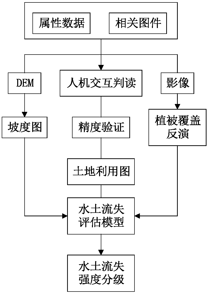
[0048] see Figure 1 to Figure 4 , the present invention provides a technical solution: a method for rapidly performing remote sensing monitoring of dynamic changes in water and soil loss, comprising:

[0049] 1) Obtain the digital elevation model of the area to be monitored, and calculate the slope factor S;

[0050] 2) Obtain remote sensing images of multiple years in the area to be monitored;

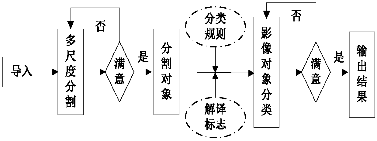
[0051] 3) according to 2) to obtain the remote sensing images of multiple years of the area to be monitored to perform land classification respectively, and obtain the land classification factor L of the multiple years of the area to be monitored;

[0052] Simultaneously,

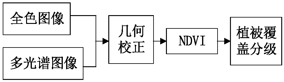
[0053] According to 2) the remote sensing images obtained in multiple years of the area to be monitored are respectively inverted using the normalized difference vegetation index to obtain the vegetation coverage factor C of the area to be monitored in multiple years;

[0054] 4) According to the soil loss esti...


PUM


Abstract

The invention discloses a method for rapidly performing remote sensing monitoring of dynamic changes of water and soil erosion. The method comprises the step that (1) a gradient factor S of a region to be monitored is obtained; (2) remote sensing images of a plurality of years of the region to be monitored are acquired; (3) according to the remote sensing images of the multiple years in the regionto be monitored obtained in the step (2) are separately subjected to land classification, and a land classification factor L of the multiple years in the region to be monitored is obtained; accordingto the remote sensing images of the multiple years of the region to be monitored obtained in the step (2) are separately subjected to inversion by using normalized vegetation indexes, and a vegetation coverage factor C of the multiple years in the region to be monitored is obtained; (4) a water and soil erosion value A of the multiple years in the region to be monitored is calculated according toa water and soil erosion estimation formula of A=S*L*C; and (5) the conversion and superposition analysis are performed on specific different grade values of water and soil erosion in adjacent years,and the continuous change values of water and soil erosion in the multiple years in the region to be monitored are obtained. Rapid extraction of water and soil erosion regions in a large region is realized, the monitoring cost is low, and dynamic monitoring of water and soil erosion is very convenient and effective.

Description

technical field [0001] The invention relates to the technical field of water and soil loss, in particular to a method for rapidly performing remote sensing monitoring of dynamic changes of water and soil loss. Background technique [0002] Soil erosion refers to the phenomenon that due to the influence of natural or human factors, rainwater cannot be absorbed on the spot, flows downhill, and scours the soil, resulting in the simultaneous loss of water and soil. The main reasons are the large slope of the ground, improper land use, destruction of ground vegetation, unreasonable farming techniques, loose soil, deforestation, overgrazing, etc. The harm of water and soil loss is mainly manifested in: the soil cultivation layer is eroded and destroyed, which makes the land fertility gradually exhausted; silting up rivers, channels and reservoirs, reducing the benefits of water conservancy projects, and even causing floods and droughts, seriously affecting industrial and agricultu...

Claims


Application Information

Patent Timeline
Patent Type & Authority Applications(China)
IPC IPC(8): G01S17/89
CPCG01S17/89
Inventor 杨学志王冬董张玉方帅郎文辉
Owner HEFEI UNIV OF TECH
Why Eureka
Try Eureka