
Autonomous mobile robot navigation method comprehensively adopting artificial road signs and grid map

A mobile robot and grid map technology, applied in the field of mobile robots, can solve problems such as high cost and complex implementation methods, and achieve the effects of improving accuracy, low cost, and improving stability and reliability.

Inactive Publication Date: 2019-04-12
YANCHENG INST OF TECH
View PDF5 Cites 1 Cited by
  • Summary
  • Abstract
  • Description
  • Claims
  • Application Information

AI Technical Summary

Problems solved by technology

Absolute positioning is to use the external reference system to achieve positioning by measuring the absolute position of the mobile robot. It mainly includes network positioning, road sign positioning, and map matching positioning. Its advantages are high positioning accuracy and no cumulative error, but the implementation method is complicated. Need to use expensive sensors such as lidar and camera, and the cost is high

Method used


Image

  • Autonomous mobile robot navigation method comprehensively adopting artificial road signs and grid map
  • Autonomous mobile robot navigation method comprehensively adopting artificial road signs and grid map
  • Autonomous mobile robot navigation method comprehensively adopting artificial road signs and grid map

Examples


Embodiment Construction

[0027] The present invention will be further described below in conjunction with the accompanying drawings.

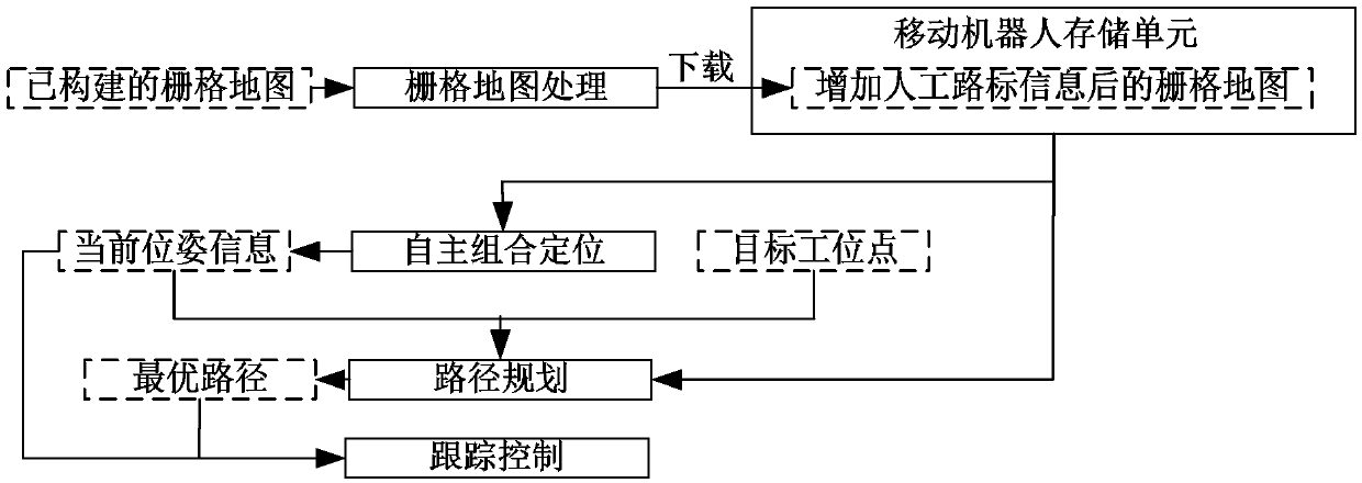
[0028] The present invention proposes a mobile robot autonomous navigation method that comprehensively applies artificial landmarks and grid maps, and its flow is as follows: figure 1 shown, including steps:

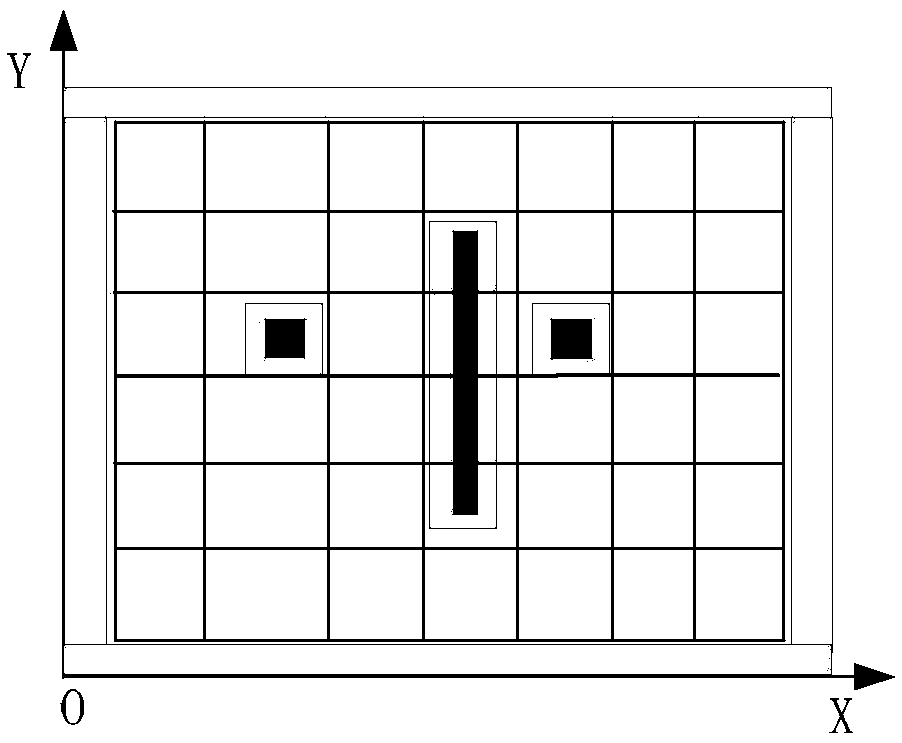
[0029] (1) Grid map preprocessing: obtain the grid map, and expand the obstacles in the grid map;

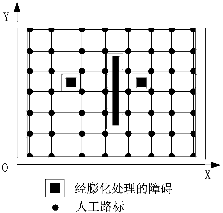
[0030] (2) Artificial landmarks are set on the grid points of the preprocessed grid map, and the artificial landmarks store their own coordinates, orientation and the distance between themselves and adjacent grids, and the artificial landmarks store the Data can be read by mobile robots;

[0031] (3) The mobile robot downloads the grid map, obtains the obstacle position information and the artificial landmark position information in the grid map; the mobile robot obtains the target station specified by the system task, and uses the grid point closest to the curre...


PUM


Abstract

The invention provides an autonomous mobile robot navigation method comprehensively adopting artificial road signs and a grid map. The method is based on the grid map with the artificial road signs. During the navigation process of a robot, a free combination positioning mode of combining absolute positioning and relative positioning is adopted, that is the distance between the robot and the nextartificial landmark is predicted by relative positioning. Before the robot is close to the artificial road sign, the robot decelerates in advance and adjusts the gesture to improve accuracy of obtaining the artificial road sign. After the road sign is obtained, the relative positioning cumulative errors are cleared to improve accuracy of relative positioning. The absolute positioning and relativepositioning path planning technologies are combined to achieve autonomous navigation of the mobile robot.

Description

technical field [0001] The invention relates to the field of mobile robots, in particular to an autonomous navigation method for a mobile robot that comprehensively applies artificial road signs and grid maps. This method is mainly used when the environmental information is known and the grid map of the environmental site has been established. Background technique [0002] Autonomous navigation technology is the core technology for mobile robots to realize autonomous movement, mainly including autonomous positioning, path planning, tracking control, etc. At present, there are many realization schemes for autonomous mobile robot navigation, but none of them are perfect. Autonomous positioning is the prerequisite for mobile robots to achieve autonomous navigation. It is necessary to determine their own position and posture information relative to the external environment in real time, that is, autonomous positioning. Commonly used autonomous positioning technologies can be di...

Claims


Application Information

Patent Timeline
Patent Type & Authority Applications(China)
IPC IPC(8): G01C21/32G01C21/16G01C21/34
CPCG01C21/165G01C21/32G01C21/3446
Inventor 肖海宁张炯楼佩煌武星郭大宏刘黎明钱晓明石陈陈王龙军曾勇郑竹安
Owner YANCHENG INST OF TECH
Learn More