A method and system for automatically obtaining magnetic inclination and declination

A technology of automatic acquisition and magnetic inclination, which is applied in the directions of instruments, surveying and navigation, measuring devices, etc., can solve the problem of inconvenience such as the inability to query the magnetic inclination and declination of the location, and achieve the effect of accurate positioning and improving efficiency.

Active Publication Date: 2021-04-02
深圳市科卫泰实业发展有限公司
View PDF3 Cites 0 Cited by
  • Summary
  • Abstract
  • Description
  • Claims
  • Application Information

AI Technical Summary

Problems solved by technology

[0004] However, when the electronic compass calculates the heading, it needs to manually input or write the magnetic inclination and magnetic declination in the area. In this way, the operator must be required to query the magnetic inclination and magnetic declination of the location in advance, and then update and use it through device interaction. Magnetic inclination and magnetic declination, this method is very inconvenient, and in the absence of data services, the magnetic inclination and magnetic declination of the location cannot be queried

Method used


Image

  • A method and system for automatically obtaining magnetic inclination and declination
  • A method and system for automatically obtaining magnetic inclination and declination

Examples


Embodiment Construction
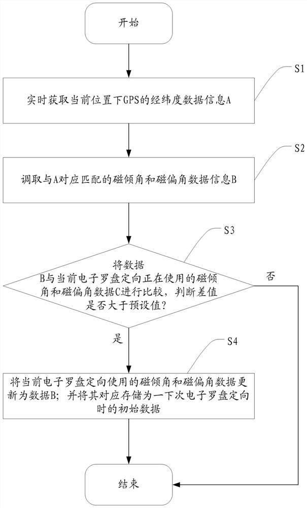
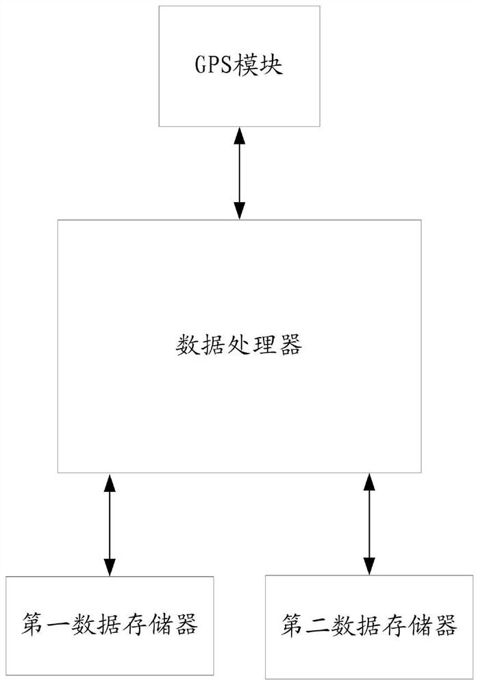
[0029] The core idea of ​​the present invention is: according to the longitude and latitude of each different region in the world, subdivide the magnetic inclination and magnetic declination of the corresponding region, and store them in a specific format in a non-volatile memory; when the device is in use, the detection device GPS signal, and when the GPS signal is good, according to the longitude and latitude information obtained by GPS, correspondingly read the corresponding matching magnetic inclination and magnetic declination from the non-volatile memory; then judge the current magnetic inclination and magnetic declination According to the difference between the magnetic inclination and declination read by the GPS latitude and longitude, if the difference is too large, update the currently used magnetic inclination and magnetic declination, and write the new magnetic inclination and magnetic declination into the non-volatile stored in memory for the next recall.

[0030]...


PUM


Abstract

The invention discloses a method and system for automatically acquiring a magnetic dip and a magnetic declination. The method is characterized in that by pre-storing the magnetic dip and magnetic declination data information of different regions around the world, matching characteristics of the GPS latitude and longitude information and the magnetic dip and magnetic declination data information are utilized to obtain accurate magnetic dip and magnetic declination data of a region where a device is operated, so the system automatically retrieves the appropriate and accurate magnetic dip and magnetic declination data according to the GPS latitude and longitude, efficiency of system operation is greatly improved, and thereby accurate positioning of an electronic compass in the case of no dataservices is realized.

Description

technical field [0001] The invention relates to an electronic compass orientation technology, in particular to a method and system for automatically obtaining magnetic inclination and magnetic declination based on GPS latitude and longitude, and realizing electronic compass orientation in unmanned equipment. Background technique [0002] Electronic compass, also known as digital compass, has been widely used as a navigation instrument or attitude sensor in modern technical conditions. Compared with the traditional pointer type and gimbal structure compass, the electronic compass has low energy consumption, small size, light weight, high precision, miniaturization, and its output signal can be processed to realize digital display, which can not only be used for pointing, but also It can directly realize the advantages of unmanned equipment control, so it is widely used in aviation, aerospace, robotics, navigation, vehicle autonomous navigation and other fields. [0003] At p...

Claims


Application Information

Patent Timeline
Patent Type & Authority Patents(China)
IPC IPC(8): G01C17/32
Inventor 李明富王秀珍齐如海王鑫刘敏
Owner 深圳市科卫泰实业发展有限公司
Why Eureka
Try Eureka