Forest fire monitoring method based on 3S technology

A forest fire and fire technology, applied in the field of forest fire monitoring, can solve the problems of low recognition efficiency, achieve the effects of improving accuracy, reducing impact, and saving manpower and time

Inactive Publication Date: 2019-05-21
中科光启空间信息技术有限公司
View PDF12 Cites 11 Cited by
  • Summary
  • Abstract
  • Description
  • Claims
  • Application Information

AI Technical Summary

Problems solved by technology

When a large area is affected by a disaster, these data and means can be used to identify the fire area and the affected area relatively accurately. However, since the spatial resolution of NOAA/AVHRR and MODIS data is low...

Method used


Image

  • Forest fire monitoring method based on 3S technology
  • Forest fire monitoring method based on 3S technology
  • Forest fire monitoring method based on 3S technology

Examples


Embodiment Construction

[0049] The core of the invention is to provide a forest fire monitoring method based on 3S technology.

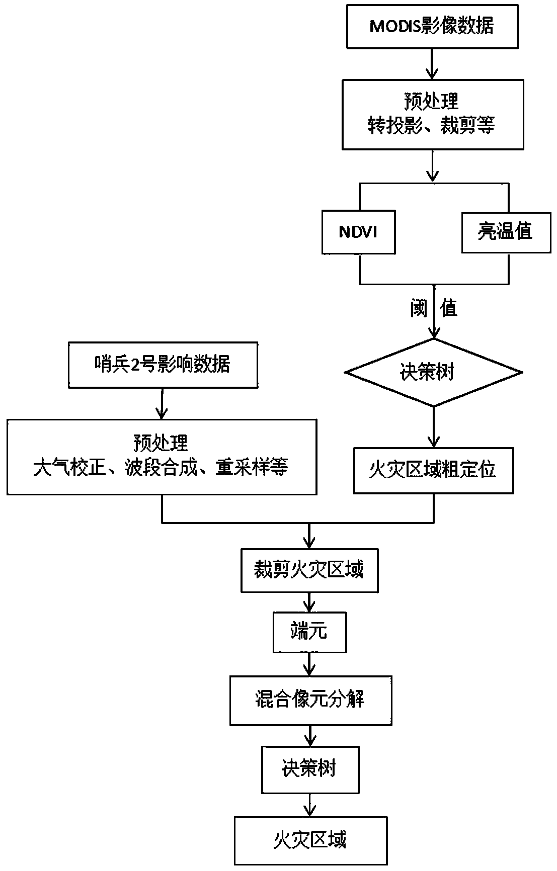
[0050] Such as figure 1 Shown, a kind of forest fire monitoring method based on 3S technology, comprises the following steps:

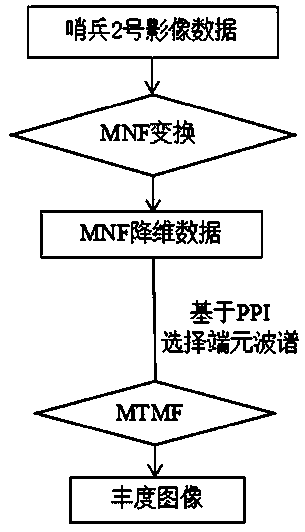
[0051]Step 1) After receiving the preliminary fire information, immediately download the post-disaster MODIS data including the low-medium resolution of the disaster area and the pre-disaster and post-disaster multi-spectral high-resolution Sentinel-2 from the NASA official website and the ESA data distribution website Remote sensing monitors satellite images and processes them to prepare data for later fire identification;

[0052] 1.1 Processing steps of MODIS data:

[0053] a. Preprocessing, including image stitching, reprojection, format conversion, radiometric calibration and atmospheric correction; said image stitching, reprojection, and format conversion are to use the processing tool MRT for MODIS data to complete the image stitching of M...


PUM


Abstract

The invention belongs to the technical field of forest fire monitoring methods. The invention particularly relates to a forest fire monitoring method based on the 3S technology which is used for monitoring forest fire by combining medium-resolution remote sensing data, multispectral high-resolution remote sensing images and GPS positioning sampling information, and can improve the accuracy and efficiency of fire information identification. The method comprises the steps: processing medium and low resolution MODIS data of a disaster area, multispectral high resolution sentry number 2 remote sensing monitoring satellite images before and after the disaster, field data acquisition, identification of a fire area and generation of a monitoring service report. The method for improving the remotesensing interpretation efficiency through field sampling has the advantages that technicians can obtain image data in real time, fire area coarse positioning can be rapidly conducted through images with medium resolution, and finally accuracy and rapidness are achieved by combining GPS positioning sampling information.

Description

technical field [0001] The invention belongs to the technical field of forest fire monitoring methods, and particularly relates to monitoring forest fires by combining medium-resolution remote sensing data, multi-spectral high-resolution remote sensing images, and GPS positioning sampling information, which can improve the accuracy and efficiency of fire information identification Forest fire monitoring method based on 3S technology. Background technique [0002] In the existing forest fire monitoring technology: after a forest fire occurs, the corresponding remote sensing images of the fire area are obtained first. At present, the medium and low resolution data of NOAA / AVHRR and MODIS are used most, and then the data are preprocessed and synthesized through three channels The fire point identification method or the absolute fire point identification method or the contextual fire point identification method is used to identify the fire point area, calculate the fire area, an...

Claims


Application Information

Patent Timeline
IPC IPC(8): G08B17/00G08B17/12
Inventor 常利蒋鹏飞张雨晨王韶彬
Owner 中科光启空间信息技术有限公司
Why Eureka
Try Eureka