Farmland landscape small-scale ground object classification method and system

A technology for classification of ground features and farmland landscapes, applied in the field of small-scale ground features classification methods and systems in farmland landscapes, can solve the problems of small-scale ground features and high-resolution image limitations that have not yet been followed up

Active Publication Date: 2019-05-31
SHENYANG AGRI UNIV +1
View PDF18 Cites 3 Cited by
  • Summary
  • Abstract
  • Description
  • Claims
  • Application Information

AI Technical Summary

Problems solved by technology

However, the existing high-resolution images are limited by interpretation methods, and a meth

Method used


Image

  • Farmland landscape small-scale ground object classification method and system
  • Farmland landscape small-scale ground object classification method and system
  • Farmland landscape small-scale ground object classification method and system

Examples


Embodiment 1

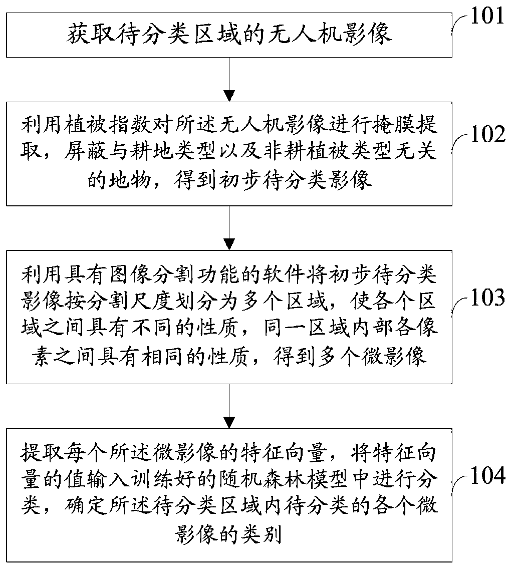
[0061] figure 1 It is a method flowchart of the method for classifying small-scale features of farmland landscape in Embodiment 1 of the present invention.

[0062] see figure 1 , the small-scale classification method of farmland landscape, including:

[0063] Step 101: Obtain the drone image of the area to be classified;

[0064] Step 102: Using the vegetation index to perform mask extraction on the UAV image, shielding the ground features that are not related to the type of cultivated land and the type of non-cultivated vegetation, and obtaining a preliminary image to be classified;

[0065] Step 103: Use the software with image segmentation function to divide the preliminary image to be classified into multiple regions according to the segmentation scale, so that each region has different properties, and the pixels in the same region have the same properties, thus obtaining multiple microimages;

[0066] Step 104: Extract the feature vector of each micro-image, input th...

Embodiment 2

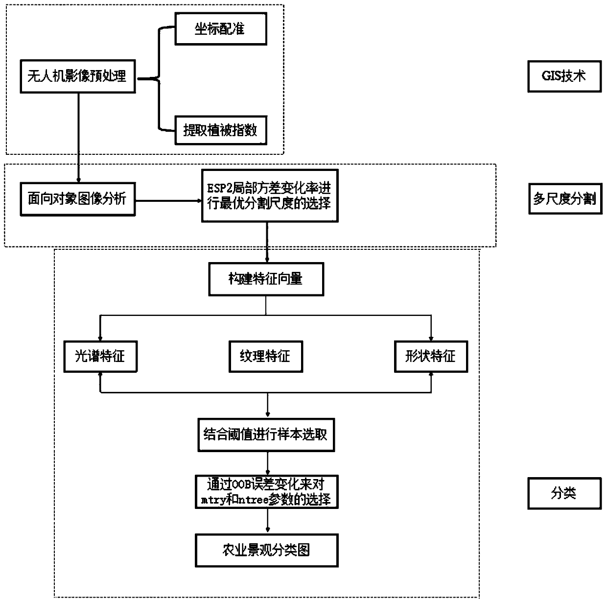
[0085] figure 2 It is an overall flow chart of the method for classifying small-scale features of farmland landscape in Embodiment 2 of the present invention.

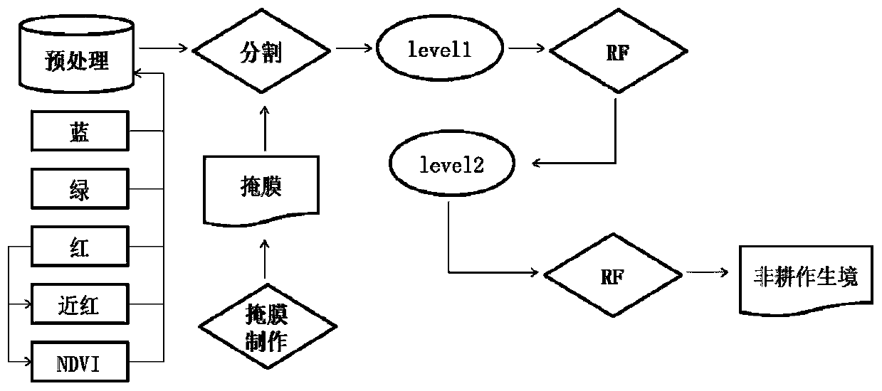
[0086] image 3 It is a specific flow chart of the method for classifying small-scale features of farmland landscape in Embodiment 2 of the present invention.

[0087] see figure 2 and image 3 , the method is divided into three processes: preprocessing based on GIS technology, multi-scale segmentation and classification.

[0088] Preprocessing based on GIS technology:

[0089] Firstly, the UAV image of the area to be classified is obtained. Then register, and then use the vegetation index to extract the mask of the UAV image, shield the ground objects that have nothing to do with the type of cultivated land and the type of non-cultivated vegetation, and obtain the preliminary image to be classified.

[0090] Carry out coordinate registration to described UAV image, and calculate the vegetation index and EVI2 i...

Embodiment 3

[0145] This embodiment is a small-scale feature classification system for farmland landscape.

[0146] The small-scale classification system of farmland landscape includes:

[0147] The obtaining module is used to obtain the unmanned aerial vehicle image of the area to be classified;

[0148] The mask extraction module is used to extract the mask of the UAV image by using the vegetation index, shield the ground features that are not related to the cultivated land type and the non-cultivated vegetation type, and obtain the preliminary image to be classified;

[0149] The segmentation scale division module is used to divide the preliminary image to be classified into multiple areas according to the segmentation scale by using software with image segmentation function, so that each area has different properties, and each pixel in the same area has the same properties, so as to obtain multiple micro-images;

[0150] The random forest model classification module is used to extrac...


PUM


Abstract

The invention discloses a farmland landscape small-scale ground object classification method and system. The classification method comprises the steps of obtaining an unmanned aerial vehicle image ofa to-be-classified region; Performing mask extraction on the unmanned aerial vehicle image by utilizing the vegetation index, and shielding ground objects irrelevant to the cultivated land type and the non-cultivated vegetation type to obtain a preliminary to-be-classified image; Dividing the preliminary to-be-classified image into a plurality of regions according to a division scale by using software with an image division function, so that the regions have different properties, and pixels in the same region have the same properties, thereby obtaining a plurality of micro-images; And extracting a feature vector of each micro-image, inputting the value of the feature vector into the trained random forest model for classification, and determining the category of each micro-image to be classified in the region to be classified. According to the classification method and system, recognition and classification of small-scale ground objects can be achieved for high-resolution images.

Description

technical field [0001] The invention relates to the technical field of remote sensing, in particular to a method and system for classifying small-scale features of farmland landscapes. Background technique [0002] To study high-precision farmland landscapes, it is necessary to produce high-resolution small-scale maps to identify small non-cultivated landscape types. Due to the requirements of data sources and mapping procedures, the interpretation accuracy of previous mapping scales is not very high. Most of the interpretation objects are large-scale land objects such as cultivated land or wetlands, and the recognition accuracy of non-cultivated habitats with small internal areas or single existence is relatively low. Low, the area is less than 400m 2 Small-scale non-cultivated habitat landscapes such as 2m in width and a width of 2m are missing, and it is difficult to meet the requirements for the analysis of farmland biodiversity and farmland landscape structure. In rec...

Claims


Application Information

Patent Timeline
IPC IPC(8): G06K9/00G06K9/34G06K9/62
Inventor 边振兴于淼王帅王秋兵车成龙王富宇陈柳
Owner SHENYANG AGRI UNIV
Why Eureka
Try Eureka