The invention discloses a remote sensing image classification method and system based on self-adaptive spatial information

A technology of remote sensing image and spatial information, applied in the field of remote sensing image processing

Active Publication Date: 2019-05-31
LANZHOU JIAOTONG UNIV
View PDF5 Cites 8 Cited by
  • Summary
  • Abstract
  • Description
  • Claims
  • Application Information

AI Technical Summary

Problems solved by technology

[0005] Based on this, it is necessary to provide a remote sensing image classification method and system based on adaptive spatial informatio

Method used


Image

  • The invention discloses a remote sensing image classification method and system based on self-adaptive spatial information
  • The invention discloses a remote sensing image classification method and system based on self-adaptive spatial information
  • The invention discloses a remote sensing image classification method and system based on self-adaptive spatial information

Examples


Embodiment Construction

[0086] The following will clearly and completely describe the technical solutions in the embodiments of the present invention with reference to the accompanying drawings in the embodiments of the present invention. Obviously, the described embodiments are only some, not all, embodiments of the present invention. Based on the embodiments of the present invention, all other embodiments obtained by persons of ordinary skill in the art without making creative efforts belong to the protection scope of the present invention.

[0087] In order to make the above objects, features and advantages of the present invention more comprehensible, the present invention will be further described in detail below in conjunction with the accompanying drawings and specific embodiments.

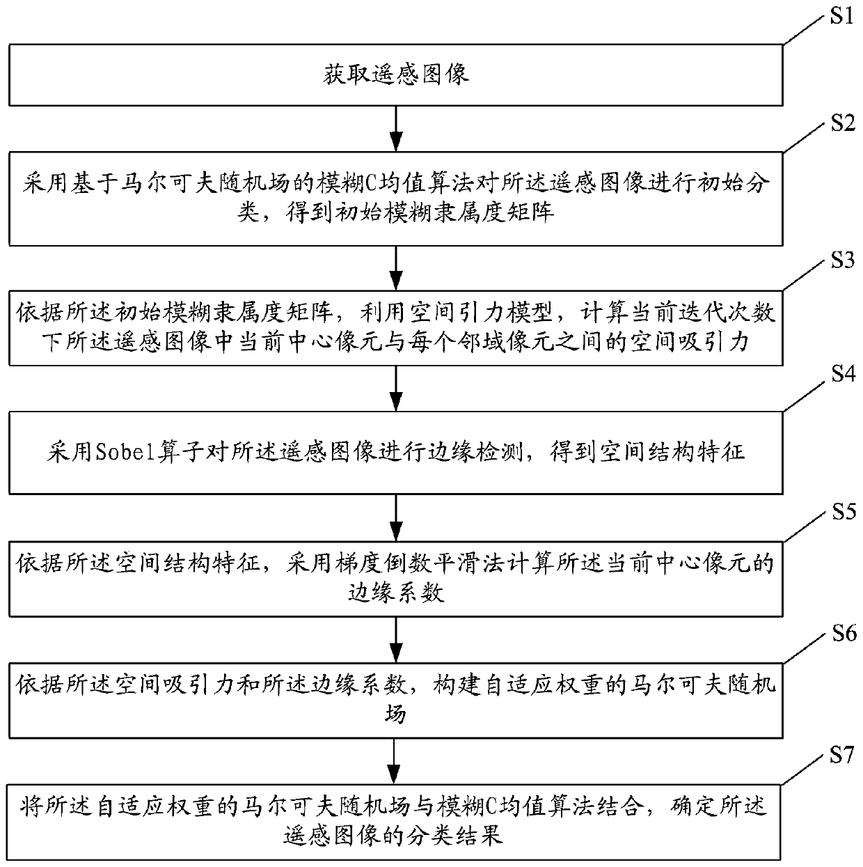
[0088] figure 1 It is a flowchart of a remote sensing image classification method based on adaptive spatial information according to an embodiment of the present invention.

[0089] see figure 1 , the remote sen...


PUM


Abstract

The invention discloses a remote sensing image classification method and system based on self-adaptive spatial information. The method comprises the steps of obtaining a remote sensing image; Performing initial classification on the remote sensing image by adopting a fuzzy C-means algorithm based on a Markov random field to obtain an initial fuzzy membership matrix; Calculating spatial attractionbetween a current central pixel and each neighborhood pixel in the remote sensing image under the current iteration frequency b by utilizing a spatial gravitation model; Performing edge detection on the remote sensing image by adopting a Sobel operator to obtain spatial structure characteristics; Calculating an edge coefficient of the current central pixel by adopting a gradient reciprocal smoothing method according to the spatial structure characteristics; Constructing a Markov random field with adaptive weight according to the space attraction and the edge coefficient; And combining the Markov random field with adaptive weight with a fuzzy C-means algorithm to determine a classification result of the remote sensing image. According to the method, the problem of boundary pixel and spatialinformation weight coefficient estimation can be effectively solved, and the classification precision is improved.

Description

technical field [0001] The invention relates to the technical field of remote sensing image processing, in particular to a remote sensing image classification method and system based on adaptive spatial information. Background technique [0002] With the rapid development of remote sensing technology, remote sensing images are widely used in land resources, environmental monitoring, urban planning and other fields. In order to meet the application requirements in different fields, it is necessary to extract a large amount of useful information from remote sensing images, among which remote sensing image classification is the key technology of information extraction, and it is also the basis for subsequent remote sensing image object recognition. Because high-spatial-resolution remote sensing images contain complex ground object information, the spectral heterogeneity of similar ground objects is obvious, and the spectra of different ground objects overlap with each other, so...

Claims


Application Information

Patent Timeline
IPC IPC(8): G06K9/62
Inventor 王阳萍党建武金秋含杨景玉张振海闵永智陈永杨艳春沈瑜林俊亭张鑫张雁鹏
Owner LANZHOU JIAOTONG UNIV
Why Eureka
Try Eureka