
A system and method for generating a UAV autonomous tracking path model

A technology for generating systems and drones, applied in three-dimensional position/channel control, etc., can solve problems such as high risk, increased safety hazards, and tediousness, and achieve the effects of strong anti-interference ability, guaranteed consistency, and improved accuracy

Active Publication Date: 2022-03-18
成都优艾维智能科技有限责任公司
View PDF9 Cites 0 Cited by
  • Summary
  • Abstract
  • Description
  • Claims
  • Application Information

AI Technical Summary

Problems solved by technology

[0002] At present, the demand for drones in the industrial field is increasing, and they are used in various aspects such as national defense, agriculture, electric power, fire protection, and public security. There is a great demand for some occasions that cannot be successfully completed by conventional manpower; especially in In the field of inspection, drones have a very important application. There are two main inspection methods: one is to control the drone for inspection by the drone pilot, but this method is extremely dependent on the pilot's technology , if you want to conduct regular inspections on the same tower, it will undoubtedly increase safety hazards, and it is difficult for the pilot to control the flight to ensure the consistency of the inspection path, which increases the workload of later data analysis; second, according to the GPS information of the tower and the Detailed parameters such as tower type, voltage level, tower height, insulator material, etc. are used to generate waypoint paths, thereby guiding drones to conduct autonomous inspections
This method requires the cooperation of relevant departments to provide accurate data, which is relatively cumbersome and has certain restrictions. Moreover, if there is a deviation in the provided data, the aircraft may crash into the tower, which is extremely risky.

Method used


Image

  • A system and method for generating a UAV autonomous tracking path model
  • A system and method for generating a UAV autonomous tracking path model
  • A system and method for generating a UAV autonomous tracking path model

Examples


Embodiment Construction

[0044] The technical solution of the present invention will be further described in detail below in conjunction with the accompanying drawings, but the protection scope of the present invention is not limited to the following description.

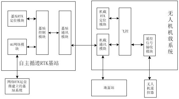
[0045] Such as figure 1 As shown, a generation system of UAV autonomous tracking path model, including:

[0046] The UAV remote control is used for the pilot to remotely control the UAV, generate control data and transmit it to the UAV airborne system;

[0047] The RTK base station is used to obtain the network positioning information of the network RTK base station group through the 4G network, combine it with the RTK satellite positioning information of the RTK base station, calculate the positioning calibration data of the UAV, and transmit it to the UAV airborne system;

[0048] The UAV airborne system controls the flight of the UAV according to the data from the UAV remote control, combines the RTK satellite positioning information of...


PUM


Abstract

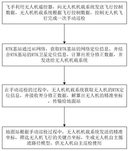
The invention discloses a system and method for generating an autonomous tracking path model of an unmanned aerial vehicle. The system includes: an unmanned aerial vehicle remote control, used for the pilot to perform remote control operations on the unmanned aerial vehicle, generate control data and transmit it to The UAV airborne system; the RTK base station, which obtains the network positioning information of the network RTK base station group, and combines it with the RTK satellite positioning information of the RTK base station to calculate the positioning and calibration data of the UAV; The data of the human-machine remote control controls the flight of the drone, combines the RTK satellite positioning information of the drone with the positioning calibration data from the RTK base station, calculates the precise position of the drone, and sends it to the ground station; the ground station, According to the precise location information sent by the UAV airborne system, the key point coordinates of the UAV flight are screened, and the UAV autonomous tracking path model is generated. The invention is beneficial to generate an accurate autonomous tracking path model of the unmanned aerial vehicle, and brings great convenience to the autonomous inspection of the unmanned aerial vehicle.

Description

technical field [0001] The invention relates to unmanned aerial vehicle inspection, in particular to a generation system and method for an autonomous tracking path model of an unmanned aerial vehicle. Background technique [0002] At present, the demand for drones in the industrial field is increasing, and they are used in various aspects such as national defense, agriculture, electric power, fire protection, and public security. There is a great demand for some occasions that cannot be successfully completed by conventional manpower; especially in In the field of inspection, drones have a very important application. There are two main inspection methods: one is to control the drone for inspection by the drone pilot, but this method is extremely dependent on the pilot's technology , if you want to conduct regular inspections on the same tower, it will undoubtedly increase safety hazards, and it is difficult for the pilot to control the flight to ensure the consistency of the...

Claims


Application Information

Patent Timeline
Patent Type & Authority Patents(China)
IPC IPC(8): G05D1/10
Inventor 张明君陈龙龙雨君
Owner 成都优艾维智能科技有限责任公司
Learn More