Unmanned aerial vehicle scene matching and positioning method based on improved ORB feature point matching

A feature point matching and scene matching technology, applied in the field of visual navigation, can solve the problems of ORB algorithm not having scale invariance and decreasing matching accuracy rate.

Pending Publication Date: 2019-06-07
NO 20 RES INST OF CHINA ELECTRONICS TECH GRP
View PDF2 Cites 6 Cited by
  • Summary
  • Abstract
  • Description
  • Claims
  • Application Information

AI Technical Summary

Problems solved by technology

However, none of the above methods solves the defect that the ORB algorithm does not have scale invariance. When the scales of the two images to be matched are inconsistent, the matching accuracy will be greatly reduced.

Method used


Image

  • Unmanned aerial vehicle scene matching and positioning method based on improved ORB feature point matching
  • Unmanned aerial vehicle scene matching and positioning method based on improved ORB feature point matching
  • Unmanned aerial vehicle scene matching and positioning method based on improved ORB feature point matching

Examples


Embodiment Construction

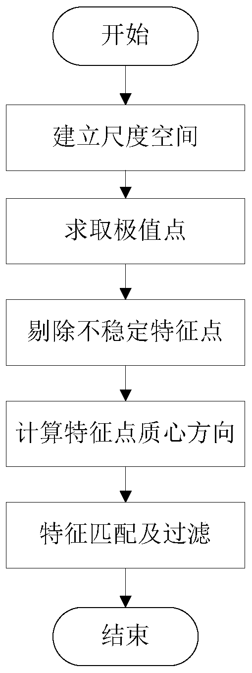
[0015] The present invention will be further described below in conjunction with the drawings and embodiments. The present invention includes but is not limited to the following embodiments.

[0016] The present invention is an autonomous positioning method for UAV scenes based on improved ORB (Oriented FAST and Rotated BRIEF) feature point matching. The UAV is positioned by acquiring real-time images of the environment and matching high-precision map libraries. Various low-altitude flight platforms such as aircraft provide navigation and positioning parameters.

[0017] The present invention includes the following steps:

[0018] (1) Establish the scale space and find the extreme points: define the scale of the image as a function F(x,y), x is the horizontal axis of the image pixel coordinate, and y is the vertical axis of the image pixel coordinate, which is convolved with the Gaussian function Obtain the scale space, and use the local extreme points of the scale space as candidat...


PUM


Abstract

The invention provides an unmanned aerial vehicle scene matching and positioning method based on improved ORB feature point matching. The method comprises: defining the scale of the image as a function; taking a local extreme point of the scale space as a candidate feature point; screening the extreme points obtained in the scale space; calculating the direction of ORB feature points by using a gray centroid method; calculating the moments in the radius r range of the feature points as the centroid, taking the vector between the feature points and the centroid as the direction of the feature points, matching the feature points by using the Hamming distance, and considering that the Hamming distance of the feature points on the two images is smaller than a set threshold value, namely, the matching point. According to the method, the original ORB algorithm is improved, so that the defect that the original ORB does not have scale invariance is overcome, the rapid calculation capability ofthe ORB is reserved, and the rapid matching capability can be achieved when the scale of the image obtained by the unmanned aerial vehicle and the scale of the image pre-stored in the map library arechanged.

Description

Technical field [0001] The invention relates to a positioning method and belongs to the field of visual navigation. Background technique [0002] In recent years, the performance of UAVs in various aspects has been continuously improved, and they have been widely used in military and civilian fields such as urban counter-terrorism reconnaissance, disaster monitoring, logistics distribution, and traffic diversion. Current UAVs mainly rely on satellite navigation and positioning, but due to the inherent vulnerability of satellite navigation signals, they are extremely vulnerable to electromagnetic and obstructive environments, leaving huge hidden dangers for the implementation of UAV missions. [0003] The use of autonomous navigation is an effective way to solve navigation tasks in the environment where satellite navigation is denied. Vision-based scene matching is one of the effective means to realize autonomous navigation. Scene matching navigation is derived from the cruise miss...

Claims


Application Information

Patent Timeline
Patent Type & Authority Applications(China)
IPC IPC(8): G06T7/13G06T7/33G06T7/70G06K9/62G06K9/46
Inventor 景鑫李阳高嘉瑜李斌
Owner NO 20 RES INST OF CHINA ELECTRONICS TECH GRP
Why Eureka
Try Eureka