
Object-oriented remote sensing extraction method and system of urban impervious surface based on semantic correlation

A semantic association and object-oriented technology, applied in image analysis, instrumentation, computing, etc., can solve problems such as extraction errors, shadow and water body type confusion, and achieve the effect of easy acquisition, solving shadow and water body confusion, and avoiding a large amount of investment cost

Active Publication Date: 2022-07-19
WUHAN UNIV
View PDF3 Cites 0 Cited by
  • Summary
  • Abstract
  • Description
  • Claims
  • Application Information

AI Technical Summary

Problems solved by technology

[0003] In order to overcome the confusion of shadow and water body categories in the existing urban impermeable surface remote sensing extraction and thus affect other category extraction errors, the purpose of the present invention is to provide a semantically related object-oriented urban impervious surface remote sensing extraction technical solution

Method used


Image

  • Object-oriented remote sensing extraction method and system of urban impervious surface based on semantic correlation
  • Object-oriented remote sensing extraction method and system of urban impervious surface based on semantic correlation
  • Object-oriented remote sensing extraction method and system of urban impervious surface based on semantic correlation

Examples


Embodiment Construction

[0040] In order to better understand the technical solutions of the present invention, the present invention will be further described in detail below with reference to the accompanying drawings and embodiments.

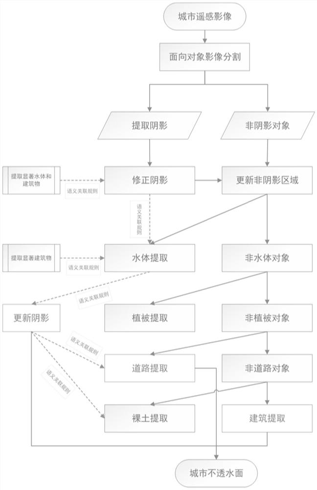
[0041] The present invention extracts spectral feature indices such as NBGI, DWVI, and FSnWI semantic association rules, purifies and corrects shadow results for many times within the extraction frame, and finally extracts urban shadow objects accurately; uses shadow objects and semantic association rules and other features to extract roads, buildings, etc. Urban impervious surfaces. The invention can accurately extract the shadows of urban buildings, thereby significantly improving the extraction accuracy of urban impervious surfaces, and solves the problem that urban water bodies and shadows are easily classified and confused.

[0042] see figure 1 , a semantically associated object-oriented urban impervious surface remote sensing extraction method provided by an ...


PUM


Abstract

The invention provides an object-oriented urban impervious surface remote sensing extraction method and system with semantic correlation, including acquiring a high-resolution multispectral remote sensing image of a target area, and performing object-oriented segmentation; Shadows, preliminarily obtain the urban shadow object area; use the roughly extracted water body, as well as the semantic association rules between buildings, water bodies and shadows to correct the shadow category; accurately extract the urban water body area from the non-shadow area, and use the semantic association rules to update the urban shadow Use vegetation index and brightness features to extract urban vegetation in non-water areas; use road-related features to extract urban roads; extract urban bare ground, and combine shadows, roads and buildings to obtain urban impervious surfaces. The invention can accurately extract the shadow of urban buildings, thereby significantly improving the extraction accuracy of the urban impervious surface, and solves the problem that the urban water body and the shadow are easily classified and confused.

Description

technical field [0001] The invention belongs to the field of information extraction of remote sensing image data, and relates to a technical scheme for inversion and extraction of urban impervious surfaces. Background technique [0002] Urban Impervious Surface (UIS) refers to an artificial surface in a city that can prevent water from infiltrating into the soil, such as buildings, roads, squares, parking lots, etc. one of the key indicators. When using high-resolution remote sensing images to extract urban impervious surfaces, the confusion of water body and shadow information is still the main problem that plagues the accurate inversion of impervious surface information. SUMMARY OF THE INVENTION [0003] In order to overcome the problem of confusion of shadow and water categories in the existing remote sensing extraction of urban impervious surfaces and thus affect the extraction of other categories, the purpose of the present invention is to provide a semantically rela...

Claims


Application Information

Patent Timeline
Patent Type & Authority Patents(China)
IPC IPC(8): G06T7/11G06T7/136G06V20/10
Inventor 邵振峰彭浩
Owner WUHAN UNIV
Learn More