A Hierarchical Mesh Division to Realize the Convergence and Dispersion Visualization Method of Massive Ground Object Marking Points

A grid division and point marking technology, which is applied in geographic information database, structured data retrieval, still image data clustering/classification, etc. Solutions and other problems to achieve the effect of improving rapid aggregation display, improving display effect, and improving versatility

Active Publication Date: 2021-10-15
CETHIK GRP
View PDF4 Cites 0 Cited by
  • Summary
  • Abstract
  • Description
  • Claims
  • Application Information

AI Technical Summary

Problems solved by technology

[0004] However, the above-mentioned aggregation algorithm needs to calculate and aggregate all the points one by one. For massive points (millions, billions), the calculation efficiency is greatly reduced, and the lack of a hierarchical processing mechanism for massive points can easily cause the load capacity of the browser to be exceeded. , the consequences of the front-end page being stuck
There is also the dispersion of aggregation points, the lack of a corresponding filtering mechanism, and the phenomenon of icon stacking cannot be avoided. In addition, due to the limitation of map providers, it is impossible to provide a solution for point aggregation and dispersion applicable to maps of various coordinate system types.

Method used


Image

  • A Hierarchical Mesh Division to Realize the Convergence and Dispersion Visualization Method of Massive Ground Object Marking Points
  • A Hierarchical Mesh Division to Realize the Convergence and Dispersion Visualization Method of Massive Ground Object Marking Points
  • A Hierarchical Mesh Division to Realize the Convergence and Dispersion Visualization Method of Massive Ground Object Marking Points

Examples


Embodiment 1

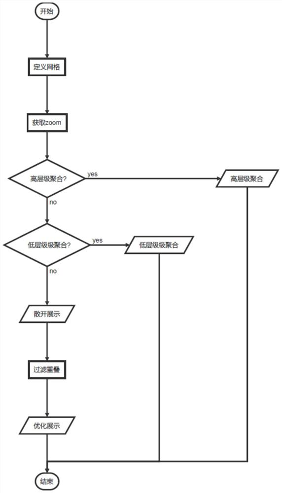
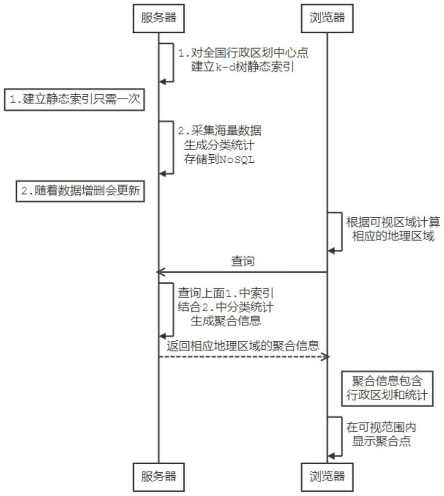
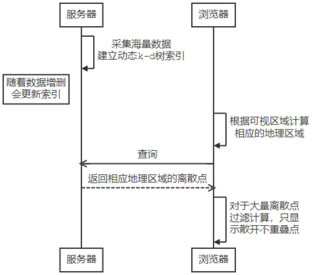
[0080] Example 1: A method for visualizing the convergence and dispersal of massive ground object markers using hierarchical grid division. The time sequence of aggregation display is as follows figure 2 As shown, the timing of the scatter display is as image 3 As shown, it specifically includes the following steps:

[0081] (1) By using the administrative area query interface provided by the online map open platform or the surveying and mapping bureau, you can obtain the current level and the next three levels (to the street level) of 23 provinces, 4 municipalities, 5 autonomous regions and 2 special administrative regions. The center point information of the administrative area (administrative area code, latitude and longitude) is persisted to the MySQL database, and the administrative area is regarded as a kind of grid division.

[0082] In this embodiment, the following rules are used to calculate the gathering and dispersing levels: the current map zoom level is above ...


PUM


Abstract

The invention discloses a layered grid division to realize the visualization method of the convergence and dispersion of massive ground object marker points, which includes obtaining the current zoom ratio of the map, and combining the preset calculation rules of the convergence and dispersion levels to determine whether the current display is aggregated or dispersed. , the step of performing the scattered display includes: obtaining the corresponding latitude and longitude range on the map according to the pixel coordinates of the visualized display area; according to the latitude and longitude range, querying the dynamic index to obtain marker information within the latitude and longitude range; using a grid filtering algorithm, The marker information is screened according to the last-in-first-out principle; the screened marker information is rendered on the map using a coordinate transformation algorithm for scattered display. The method of the invention can improve the efficiency of displaying massive data on the map, improve the recognition degree of scattered display of massive points, and realize map interactive query.

Description

technical field [0001] The invention belongs to the technical field of digital maps, and in particular relates to a layered grid division to realize a visualization method for gathering and dispersing massive ground object marker points. Background technique [0002] With the advent of the era of big data, digital map technology is also innovating in related application fields, and map visualization of massive data has emerged as the times require. The map visualization of massive data refers to displaying a large number of map markers (ground feature markers) in a limited digital map display area, usually on the computer screen, in the browser window, when the map zoom level is high, the scale It is very large, and it is difficult to display a large number of map markers. Generally, point aggregation is used. However, when the map zoom level is very low, specific map markers need to be displayed in a scattered manner. [0003] Currently, many map providers have somewhat ag...

Claims


Application Information

Patent Timeline
Patent Type & Authority Patents(China)
IPC IPC(8): G06F16/29G06F16/58G06F16/51G06F16/55
Inventor 傅晨恩陈琼曹小健
Owner CETHIK GRP
Why Eureka
Try Eureka