
Skyline evaluation method based on city live-action long volume and three-dimensional model projection

A technology of three-dimensional model and evaluation method, which is applied in the field of skyline evaluation based on urban real scene scroll and three-dimensional model projection, can solve the problem of not distinguishing between different regions, different levels, different categories, and not taking into account the different requirements of skyline evaluation, high precision Problems such as high model difficulty, to achieve the effect of convenient analysis and planning, strong realizability, and strong authenticity

Pending Publication Date: 2019-07-19
CHONGQING SURVEY INST +1
View PDF8 Cites 2 Cited by
  • Summary
  • Abstract
  • Description
  • Claims
  • Application Information

AI Technical Summary

Problems solved by technology

[0009] The existing technology can better solve the problem of urban skyline generation, but there are also the following deficiencies: it is difficult and costly to build high-precision models of the basic terrain, landforms, and buildings of the city; the existing technical solutions require high-end software and hardware The environment can simulate city-level planning schemes; the current skyline analysis only considers visibility, does not distinguish between different regions, different levels, and different categories, and does not take into account the different requirements of different regions and different categories for skyline evaluation

Method used


Image

  • Skyline evaluation method based on city live-action long volume and three-dimensional model projection
  • Skyline evaluation method based on city live-action long volume and three-dimensional model projection

Examples


Embodiment 1

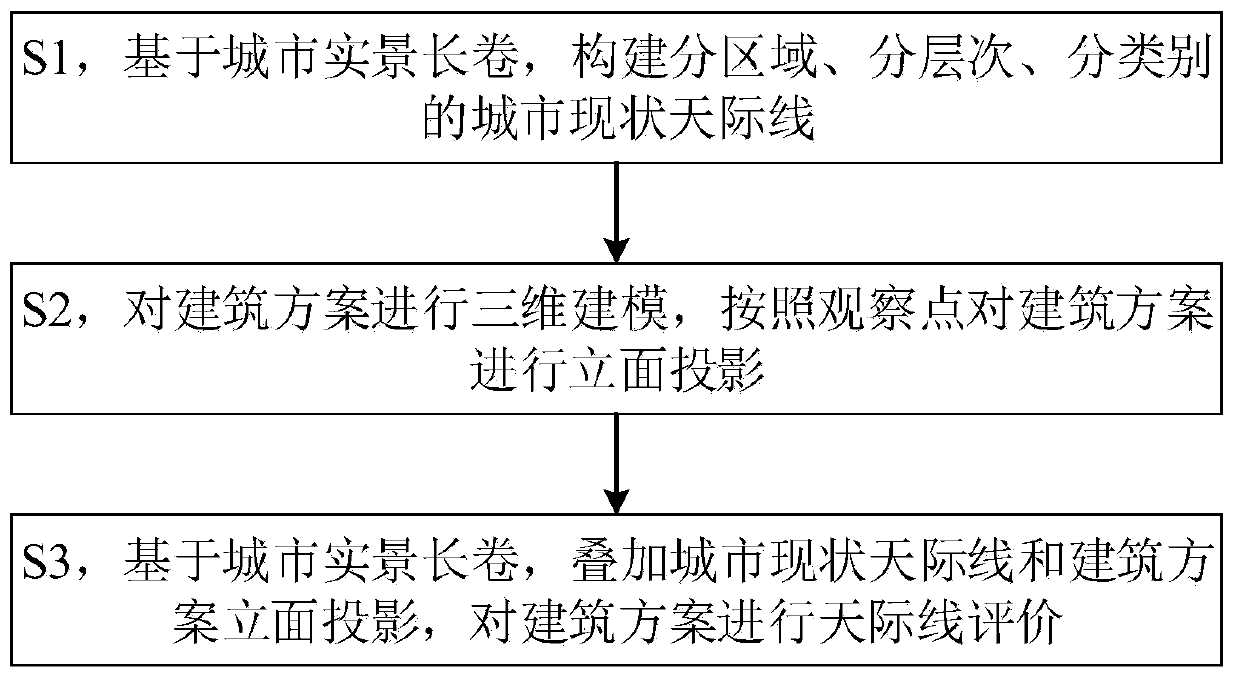
[0041] Such as figure 1 As shown, this embodiment provides a skyline evaluation method based on urban real scene scrolls and three-dimensional model projections, including the following steps:

[0042] S1, based on the long scroll of urban real scenes, construct the current urban skyline by region, level and category;

[0043] Specifically, the following steps are included:

[0044] S11, constructing the current urban area;

[0045] The current urban areas mainly include waterfront areas, mountainous areas, urban sign areas, etc., forming vector results;

[0046] S12, Constructing the status quo level of the city;

[0047] For waterfront areas and mountainous areas, the levels of near water, middle, and far water are divided to form vector results;

[0048] S13. Construct categories related to the current urban skyline;

[0049] The categories related to the city skyline include: (1) buildings, including building height, building volume, building top shape, building textu...


PUM


Abstract

The invention discloses an skyline evaluation method based on city live-action long volume and three-dimensional model projection, and the method comprises the following steps: S1, building regional,hierarchical, and classified city current situation skylines based on city live-action long volume; S2, performing three-dimensional modeling on the building scheme, and performing facade projection on the building scheme according to the observation point; and S3, based on the city live-action long volume, superposing the city current situation skyline and the building scheme elevation projection, and carrying out skyline evaluation on the building scheme. The skyline evaluation method based on the city live-action long volume and the three-dimensional model projection is not high in softwareand hardware requirements, high in realizability, low in manufacturing cost and short in production period. Since the shot real-scene image is used as the background, the authenticity is high. Vectorachievements of different areas, different levels and different types are formed respectively, so that the skyline hierarchy is stronger, and analysis and planning are more convenient.

Description

technical field [0001] The invention relates to the field of digital city planning, in particular to a skyline evaluation method based on urban real-scene scrolls and three-dimensional model projections. Background technique [0002] The city skyline is a symbol of the city, embodies the overall outline of the city, and is the most concentrated and typical embodiment of the city's style and image. The city skyline is a contour line composed of various topography and features with the sky as the background, and is a vertical spatial projection of the overall appearance of the city. Kevin Lynch pointed out in "The Image of the City" that a good urban visual quality has distinct recognizability, including roads, edges, nodes, regions and signs, which have certain image characteristics, clear structure, and easy to identify. A city skyline is a boundary element, a starting point and an important factor in establishing the impressionability of a city. [0003] The city skyline ...

Claims


Application Information

Patent Timeline
IPC IPC(8): G06Q10/06G06Q50/08G06T17/00G06T3/00
CPCG06Q10/0639G06Q50/08G06T17/00G06T3/067Y02A30/60
Inventor 向泽君李锋薛梅刘寓韩熙龙川唐相桢黄志邓未江张俊
Owner CHONGQING SURVEY INST
Features
  • Generate Ideas
  • Intellectual Property
  • Life Sciences
  • Materials
  • Tech Scout
  • Unparalleled Data Quality
  • Higher Quality Content
  • 60% Fewer Hallucinations
Learn More