Regional water body drawing method based on Landsat OLI remote sensing image

A remote sensing image and regional technology, which is applied in the field of remote sensing mapping, can solve problems such as changes in water body extraction accuracy, inconsistent water body accuracy, and time-consuming and labor-intensive threshold testing process, and achieve the effect of overcoming uncertainty and subjectivity and solving time-space differences

Active Publication Date: 2019-07-19
NANJING FORESTRY UNIV
View PDF8 Cites 11 Cited by
  • Summary
  • Abstract
  • Description
  • Claims
  • Application Information

AI Technical Summary

Problems solved by technology

[0006] (1) Existing water body index models seldom take into account the influence of remote sensing images in different geographical spaces on water reflection values. Time-consuming and labor-intensive;
[0007] (2) Most of the existing water body index models do not take into account the influence of seasonal changes on the reflectance of water bodies. Since there are certain differences in the reflectance of the same ground features in different seasons, when using a constant water body index threshold to extract water bodies, it will lead to the extracted The accuracy of the water body is inconsistent and the volatility is large;
[0008] (3) The selection of the threshold of the existing index model is highly subjective, and the accuracy of water extraction varies with the selection of the threshold

Method used


Image

  • Regional water body drawing method based on Landsat OLI remote sensing image
  • Regional water body drawing method based on Landsat OLI remote sensing image
  • Regional water body drawing method based on Landsat OLI remote sensing image

Examples


Embodiment Construction

[0050] The technical solution of the present invention will be further described below in conjunction with the accompanying drawings.

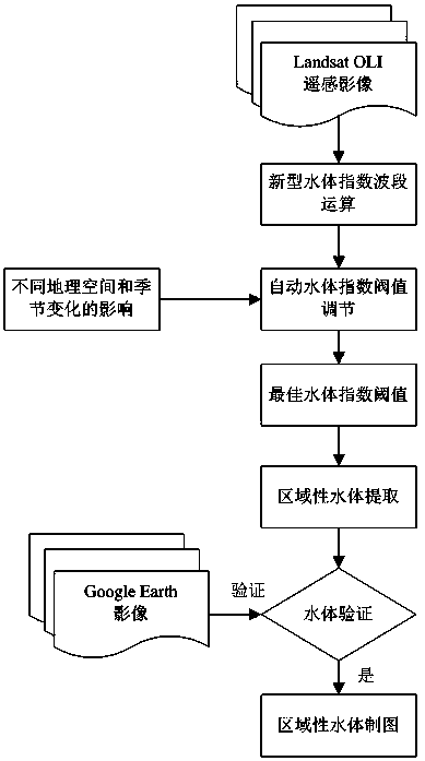
[0051] Such as figure 1 As shown, the regional water mapping method based on Landsat OLI remote sensing images, the specific steps are as follows:

[0052] 1) Construction of Universal Water Index Model (UWI):

[0053]

[0054] in Corresponding to the surface reflectance values ​​of the selected bands of remote sensing images, Mean(b i +b j ) represents the average sum of the surface reflection values ​​for the selected band, b in the present invention i The band selected as the Landsat OLI image is band seven (band7, SWIR2: 2.100-2.300 μm) or band six (band6, SWIR1: 1.560-1.660 μm), b j Band 4 (band4, Red: 0.630-0.680 μm), band 3 (band3, Green: 0.525-0.600 μm), and band 2 (band2, Blue: 0.450-0.515 μm) can be selected. The model can be combined into six indices , respectively:

[0055]

[0056]

[0057]

[0058] 2) Automati...


PUM


Abstract

The invention discloses a regional water body drawing method based on a Landsat OLI remote sensing image. The regional water body drawing method comprises the following steps: 1) constructing a universal water body index model; 2) automatically selecting an optimal water body index threshold value; 3) extracting regional water body; 4) verifying a water body extraction result; and 5) performing regional water body drawing. The method is based on an existing water body index model, and a regional water body extraction index model suitable for a Landsat OLI remote sensing image is developed. After a model wave band is adopted for operation, water body and non-water body type value domains can be effectively separated, wherein the water body shows a relatively concentrated value domain range,an image entropy algorithm is adopted to overcome the reflectivity heterogeneity of the land-saving object caused by space-time difference, and the algorithm automatically selects the optimal water body to extract the threshold value, so that the uncertainty and subjectivity of manually determining the threshold value are reduced, and the drawing precision and efficiency of the water body are improved.

Description

technical field [0001] The invention relates to a regional water body remote sensing mapping method, in particular to a regional water body mapping method based on Landsat OLI remote sensing images, and belongs to the technical field of remote sensing mapping. Background technique [0002] With the deepening and progress of research on modern water mapping methods, the construction method of water body extraction index model is also continuously improved and improved: in 1996, Mcfeeters first used green light (Green, 0.52-0.60um) band and near infrared (NIR , 0.76-0.96um) band to construct the normalized difference water index (NDWI). In 2004, Roger and Kearney used the red (Red, 0.62-0.69um) band and short-wave infrared (SWIR1, 1.55-1.75um) band to propose another An index model for water extraction, which can effectively identify water and bare soil; in 2005, Professor Xu Hanqiu used green light (Green, 0.52-0.60 μm) and short-wave infrared (SWIR1, 1.55-1.75 μm) to constru...

Claims


Application Information

Patent Timeline
Patent Type & Authority Applications(China)
IPC IPC(8): G06T11/20G06T7/136G06T7/11G06T7/194
CPCG06T11/206G06T2207/10032G06T7/11G06T7/136G06T7/194
Inventor 李明诗王玉亮
Owner NANJING FORESTRY UNIV
Why Eureka
Try Eureka