Target positioning method, device and system
A target positioning and target technology, applied in the field of photoelectric early warning, can solve the problems that a single unit cannot obtain the spatial position of the target, is not equipped with ranging function, and has intersection blind spots, etc., and achieves effective information support, efficient countermeasures, and improved tracking accuracy. Effect
Active Publication Date: 2019-08-16
CHANGCHUN INST OF OPTICS FINE MECHANICS & PHYSICS CHINESE ACAD OF SCI
6 Cites 3 Cited by
AI-Extracted Technical Summary
Problems solved by technology
[0003] Related technologies generally use optoelectronic equipment to detect the spatial position of the target. In order to take advantage of its passive and silent detection, optoelectronic equipment is generally not equipped with a ranging function, so a single unit cannot obtain the spatial position of the target.
At present, the method of intersection...
Method used
In the technical scheme that the embodiment of the present invention provides, obtain the data information that photoelectric equipment measures and the data information that radar equipment measures simultaneously to same target to be measured, then carry out data to photoelectricity and radar measurement data based on radar equipment measurement information accuracy Optimal fusion, combining the advantages of photoelectric equipment and radar equipment, not only solves the disadvantages of related technologies using photoelectric equipment to locate targets, but also realizes fast and accurate positioning of targets, effectively improves the trac...
Abstract
Embodiments of the invention disclose a target positioning method, device and system. According to the method, space-time registering is carried out on photoelectric measurement information and radarmeasurement information according to site address information and time mark information contained in the photoelectric measurement information and the radar measurement information of a target to be measured respectively; when a tracking target corresponding to the photoelectric measurement information and a tracking target corresponding to the radar measurement information are the same target, and if the distance measurement error of the radar equipment is larger than an angle measurement error, the angle measurement information in the photoelectric measurement information and the angle measurement information in the radar measurement information are fused to generate positioning information of the target to be measured; and if the distance measurement error of the radar equipment is notlarger than the angle measurement error, the angle measurement information in the photoelectric measurement information and the distance measurement information in the radar measurement information are fused to generate positioning information of the target to be measured. According to the method, the defect existing when the target is positioned by utilizing the photoelectric equipment in the related technology is overcome, and rapid and accurate positioning of the target is realized.
Application Domain
Beacon systems using electromagnetic wavesPosition fixation +1
Technology Topic
Radar measurementEnvironmental geology +2
Image
Examples
- Experimental program(1)
Example Embodiment
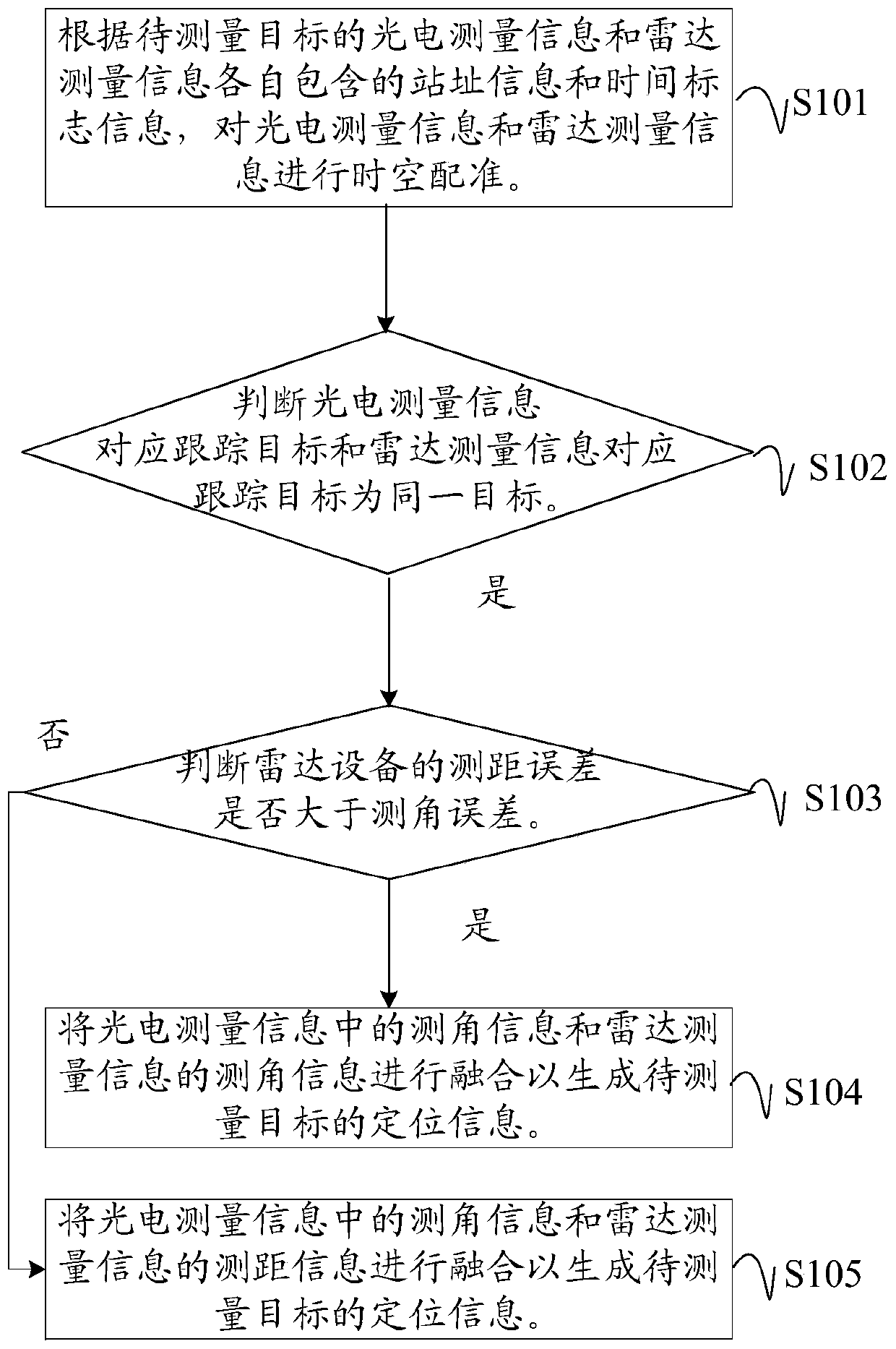
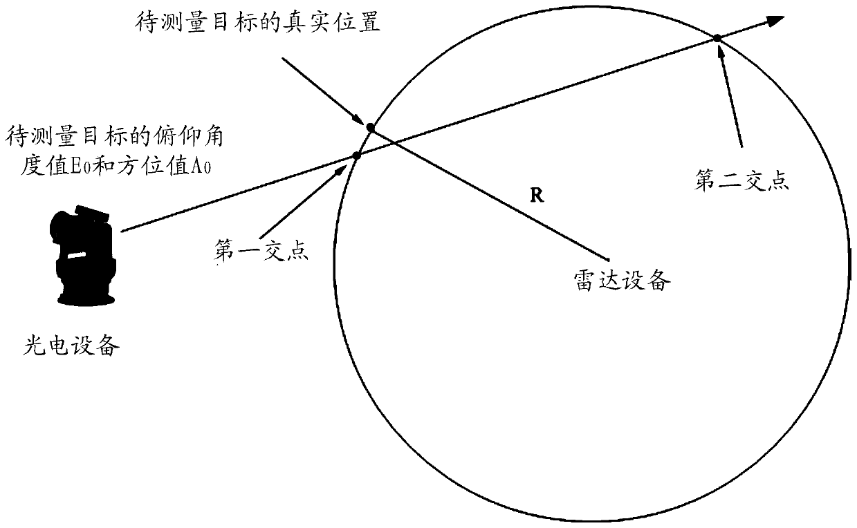
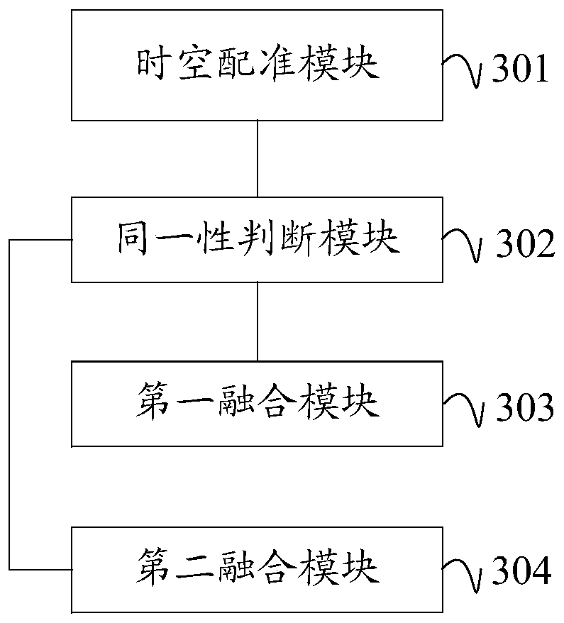
[0052] In order to enable those skilled in the art to better understand the solution of the present invention, the present invention will be further described in detail below with reference to the accompanying drawings and specific embodiments. Obviously, the described embodiments are only a part of the embodiments of the present invention, rather than all the embodiments. Based on the embodiments of the present invention, all other embodiments obtained by those of ordinary skill in the art without creative work shall fall within the protection scope of the present invention.
[0053] The terms "first", "second", "third", "fourth", etc. in the description and claims of this application and the above-mentioned drawings are used to distinguish different objects, not to describe a specific sequence . In addition, the terms "including" and "having" and any variations of them are intended to cover non-exclusive inclusion. For example, a process, method, system, product, or device that includes a series of steps or units is not limited to the listed steps or units, but may include unlisted steps or units.
[0054] After introducing the technical solutions of the embodiments of the present invention, various non-limiting implementation manners of the present application will be described in detail below.
[0055] See first figure 1 , figure 1 This is a schematic flowchart of a target positioning method provided by an embodiment of the present invention. The embodiment of the present invention may include the following content:
[0056] S101: Perform spatio-temporal registration of the photoelectric measurement information and the radar measurement information according to the site information and time stamp information contained in the photoelectric measurement information and the radar measurement information of the target to be measured.
[0057] In this application, the photoelectric measurement information is the data information generated by the photoelectric equipment when the position of the target to be measured is measured, and it carries the site information of the photoelectric equipment and the time mark information, and the photoelectric measurement information is a group including the position information of the target to be measured and Data of pitch information. Radar measurement information is the data information generated by the radar equipment during the position measurement of the target to be measured, and it carries radar equipment site information and time stamp information, and the radar measurement information is a set of ranging information and target orientation information including the target to be measured And pitch information data. After obtaining the measurement information from optoelectronic equipment and radar equipment through, for example, but not limited to, network communication, the data can be decoded according to their defined data format, and the measurement information of the target to be measured can be converted into the same expression mode. Measurement information.
[0058] It is understandable that the current position information of the target to be measured obtained by different radars is expressed in different coordinate systems. For example, the position information of SSR and PSR are in polar coordinates with the device as the origin and the direction of true north as the azimuth zero point. The position information of the target detected by MLA, ADS-B, etc. is usually expressed in geodetic coordinates, that is, longitude and latitude. Other radar devices, for example, use the device position as the origin, the direction of true north as the y-axis, and the direction of true east as The x-axis device is represented in a rectangular coordinate system. In addition, due to the different data cycles of optoelectronic devices and radars, the time of the received information is different and cannot be directly used for subsequent processing. In order to facilitate subsequent data processing, the radar measurement information and the photoelectric measurement information need to be aligned in space and time according to the site information and time mark information contained in the respective measurement information. For example, the least square method can be used to extrapolate photoelectric measurement information and radar measurement information first, and time-aligned photoelectric and radar measurement information can be obtained to align the photoelectric measurement information and radar measurement information to the same Time; Gaussian projection method can be used to convert radar measurement information into measurement data in the radar polar coordinate system (A r ,E r ,R r ), and the photoelectric equipment uses the equipment polar coordinate system for data representation (A o ,E o ), without conversion, so as to realize the conversion of photoelectric measurement information and radar measurement information into measurement data in the same coordinate system.
[0059] S102: Determine that the tracking target corresponding to the photoelectric measurement information and the tracking target corresponding to the radar measurement information are the same target, and if yes, execute S103.
[0060] It is understandable that determining whether the received measurement information of the radar equipment and the photoelectric equipment are the same target is a necessary condition for subsequent data fusion, so it is necessary to judge whether the obtained photoelectric measurement information and the radar measurement information correspond to the tracking target. For the same goal.
[0061] S103: Determine whether the ranging error of the radar device is greater than the angle measurement error, if yes, execute S104; if not, execute S105.
[0062] It is understandable that the hardware parameters of the radar equipment when it leaves the factory include ranging error or ranging accuracy, angle measurement accuracy or angle measurement error. However, as the radar equipment is worn or affected by the life span during use, the initial error data may Inaccurate, or in some special application scenarios or affected by the weather, will cause the initial error data to be inaccurate. After the radar measurement information is obtained, you can refer to any kind of detection radar equipment ranging error and ranging error Related technologies are judged, and this application does not make any limitation on this.
[0063] S104: Fusion of the angle measurement information in the photoelectric measurement information and the angle measurement information of the radar measurement information to generate positioning information of the target to be measured.
[0064] In this application, based on the relative positional relationship (entering the route) between the target to be measured and the radar equipment and optoelectronic equipment, the appropriate intersection measurement method is selected from the horizontal projection method, the vertical projection method, and the shortest distance method. The site information of the radar equipment, the angle measurement information of the photoelectric equipment and the radar equipment, calculate the position information of the target to be measured.
[0065] S105: Fusion of the angle measurement information in the photoelectric measurement information and the range measurement information of the radar measurement information to generate positioning information of the target to be measured.
[0066] In the technical solution provided by the embodiment of the present invention, the data information measured by the photoelectric device and the data information measured by the radar device are simultaneously acquired for the same target to be measured, and then the photoelectric and radar measurement data are optimized based on the accuracy of the radar device measurement information. Combining the advantages of optoelectronic equipment and radar equipment not only solves the disadvantages of using optoelectronic equipment to locate targets in related technologies, but also achieves rapid and precise positioning of targets, effectively improving target tracking accuracy, and helping to provide high-precision targets Guiding intelligence and effective information support to achieve more efficient countermeasures.
[0067] In an embodiment, when fusing the angle measurement information in the photoelectric measurement information and the ranging information of the radar measurement information, the target to be measured can be determined according to the position of the intersection of the range coverage area of the radar device and the pointing line of the photoelectric device Positioning information; the ranging coverage area takes the radar device as the center of the sphere and the distance between the radar measurement device and the target to be measured is the radius; the pointing line is the starting point of the photoelectric device, and the azimuth and elevation angle according to the photoelectric measurement information The value points to the ray of the target to be measured, see figure 2 Shown. In a specific implementation process, it can be implemented as follows:
[0068] In the rectangular coordinate system of the equipment space with the center of the optoelectronic device as the origin, the coordinates of the center of the optoelectronic device can be expressed as (x 0 ,y 0 ,z 0 )=(0,0,0), the coordinates of the radar in the equipment coordinate system (x 1 ,y 1 ,z 1 ). According to the azimuth and elevation information in the photoelectric measurement information (A o ,E o ), can get a ray starting from the photoelectric device as the origin According to the coordinates of the radar device in the device coordinate system (x 1 ,y 1 ,z 1 ) And the ranging information R in the radar measurement information r , We can get a (x 1 ,y 1 ,z 1 ) Is the center, R r Is the radius of the spherical area, the intersection position information can be calculated by formula (1):
[0069]
[0070] In the formula, (x, y, z) is the position coordinate of the target to be measured in the coordinate system, and t is the time.
[0071] By solving formula (1), the calculation formula (2) of the intersection point of the ray and the sphere can be obtained:
[0072]
[0073] It can be seen from the above that (x, y, z) has two solutions, which means that there will be two intersections at the intersection of the ray and the sphere, for example, figure 2 The first intersection point and the second intersection point are shown, and among these two intersection points, there is bound to be a point closer to the real target to be measured. This point can be determined according to the following two methods, which can specifically include:
[0074] In one embodiment, if there are two intersections between the ranging coverage area and the pointing line, the first intersection can be calculated based on the location information of the first intersection, the location information of the second intersection, and the site information of the radar equipment The first distance value with the radar device, the second intersection point and the second distance value with the radar device; calculate the difference between the distance value in the radar measurement information and the first distance value and the second distance value, and reduce the difference The position information of the intersection point is used as the positioning information of the target to be measured. That is to say, calculate the distance between the target to be measured and the radar device based on the position information of the two intersection points and the site of the radar device, compare these two values with the real target distance observed by the radar, and remove the points with larger differences. , To obtain the position value of the target to be measured after data fusion.
[0075] In another embodiment, if there are two intersections between the ranging coverage area and the pointing line, the location information of the area where the first intersection and the second intersection are located can be converted into the radar equipment observing the first intersection and the second intersection. The azimuth value and elevation value; the target azimuth value and the target elevation value of the target to be measured according to the radar equipment observation; the calculation of the difference between the target azimuth value and the azimuth value of the first and second intersection points; and the target elevation value and the first The difference between the pitch values of the intersection and the second intersection; the position information of the intersection with the smaller difference is used as the positioning information of the target to be measured. That is to say, the azimuth and elevation values of the two points observed by the radar are obtained through coordinate conversion from the position information of the two intersection points, and these two values are compared with the target azimuth and elevation values actually observed by the radar, and the points with larger differences are removed. The remaining intersection is the position value of the target to be measured after data fusion.
[0076] Due to the existence of equipment problems or interference and other factors, the received data will contain invalid target information. Therefore, after obtaining the photoelectric measurement information and radar measurement information of the target to be measured, the Kalman filter method can also be used to remove the photoelectric measurement information and radar. Invalid data in measurement information.
[0077] Usually, the identity of the target can be judged by the track correlation method. When the photoelectric equipment of this application is not equipped with a ranging system, the above method cannot be used to obtain the absolute spatial position of the target to be measured, and the traditional track correlation cannot be used. Method to judge. In this application, the method of comparing the azimuth and pitch difference of tracking and guidance and the difference of the rate of change between the two can be used to judge the identity of the target. The specific steps may include:
[0078] In the polar coordinate system with the photoelectric equipment as the origin, the least square method is used to calculate the azimuth speed information and pitch speed information of the tracking target corresponding to the photoelectric measurement information.
[0079] According to the site information of the radar measurement information, the target position information of the radar measurement information is converted into the angle information under the polar coordinates of the photoelectric device and the distance value between the target to be measured and the photoelectric device, and the azimuth and speed information of the tracking target corresponding to the radar measurement information is calculated And pitch speed information.
[0080] Calculate the change rate of the azimuth velocity difference between the photoelectric equipment and the radar device relative to the azimuth velocity value of the photoelectric device; calculate the change rate of the pitch velocity difference between the photoelectric equipment and the radar device relative to the pitch velocity value of the photoelectric device, that is, the azimuth (pitch) of the radar device The difference between the speed value and the azimuth (pitch) speed value of the photoelectric device is then divided by the azimuth (pitch) speed value of the photoelectric device; the azimuth difference and the pitch difference between the photoelectric device and the radar device are calculated.
[0081] Thresholds, such as azimuth difference threshold, pitch difference threshold, azimuth relative change rate threshold, and pitch relative change rate threshold can be determined in advance according to the measurement accuracy of photoelectric equipment and radar equipment, and the distance between the target to be measured and the photoelectric equipment, optional , Can use formula (3) to calculate each threshold:
[0082]
[0083] Among them, ΔR=3*σ r , Τ A Is the azimuth difference threshold, τ E Is the pitch difference threshold, τ VA Is the relative change rate threshold of azimuth, τ VE Is the relative rate of change threshold of pitch, σ A0 Is the azimuth angle measurement error of the photoelectric equipment, σ Ar Is the azimuth ranging error of the radar equipment, σ E0 Is the pitch angle measurement error of the radar equipment, σ Er Is the pitch angle measurement error of the radar equipment, R 0 Is the distance between the object to be measured and the photoelectric device, σ r It is the ranging error of the radar equipment.
[0084] If the change rate of the pitch speed difference between the optoelectronic device and the radar device corresponding to the pitch speed value of the optoelectronic device is not greater than the pitch relative change rate threshold, the azimuth velocity difference between the optoelectronic device and the radar device corresponds to the change in the azimuth velocity value of the optoelectronic device The rate is not greater than the azimuth relative change rate threshold, the difference between the elevation value of the radar device and the elevation value of the photoelectric device is not greater than the elevation difference threshold, and the difference between the azimuth value of the radar device and the azimuth value of the photoelectric device is not greater than the azimuth difference threshold, then It is determined that the tracking target corresponding to the photoelectric measurement information and the tracking target corresponding to the radar measurement information are the same target. Even if there is one greater than the preset threshold, it does not belong to the same target. The measurement information that meets the identity judgment condition can be saved for data fusion in subsequent steps.
[0085] The embodiment of the present invention also provides a corresponding implementation device for the target positioning method, which further makes the method more practical. The target positioning device provided by the embodiment of the present invention will be introduced below. The target positioning device described below and the target positioning method described above can be referred to each other.
[0086] See image 3 , image 3 This is a structural diagram of a target positioning device provided in an embodiment of the present invention in a specific implementation manner. The device may include:
[0087] The spatiotemporal registration module 301 is used to perform spatiotemporal registration of the optoelectronic measurement information and the radar measurement information according to the site information and time stamp information contained in the photoelectric measurement information and the radar measurement information of the target to be measured.
[0088] The identity judgment module 302 is used to judge whether the tracking target corresponding to the photoelectric measurement information and the tracking target corresponding to the radar measurement information are the same target.
[0089] The first fusion module 303 is used for fusing the angle measurement information in the photoelectric measurement information and the angle measurement information of the radar measurement information to generate the positioning information of the target to be measured if the ranging error of the radar device is greater than the angle measurement error.
[0090] The second fusion module 304 is used for fusing the angle measurement information in the photoelectric measurement information and the ranging information of the radar measurement information to generate the positioning information of the target to be measured if the ranging error of the radar device is not greater than the angle measurement error.
[0091] Optionally, in some implementations of this embodiment, the second fusion module 304 may also be a module that determines the positioning information of the target to be measured according to the position of the intersection of the range coverage area of the radar device and the pointing line of the optoelectronic device ; Among them, the ranging coverage area takes the radar device as the center of the sphere and the distance between the radar measurement device and the target to be measured is the radius; the pointing line is the starting point of the photoelectric device, and the azimuth and elevation angles based on the photoelectric measurement information The value points to the ray of the target to be measured.
[0092] In some other embodiments, the second fusion module 304 may include:
[0093] Judgment sub-module for judging whether there are two intersections between the ranging coverage area and the pointing line;
[0094] The calculation sub-module is used to calculate the first intersection point and the radar equipment based on the position information of the first intersection point, the position information of the second intersection point, and the site information of the radar equipment if there are two intersection points between the coverage area and the pointing line. A distance value, the second distance value between the second intersection point and the radar device; calculate the difference between the distance value in the radar measurement information and the first distance value and the second distance value;
[0095] The positioning information determining sub-module is used to use the position information of the intersection with a small difference as the positioning information of the target to be measured.
[0096] In some other embodiments, the second fusion module 304 may further include:
[0097] Judgment sub-module for judging whether there are two intersections between the ranging coverage area and the pointing line;
[0098] The calculation sub-module is used to convert the position information of the area where the first intersection and the second intersection are located into the azimuth value and pitch of the radar equipment observation of the first intersection and the second intersection if there are two intersections between the coverage area and the pointing line Calculate the difference between the target azimuth value of the target to be measured observed by the radar equipment and the azimuth value of the first and second intersection points; and the target pitch value of the target to be measured observed by the radar equipment and the first and second intersection points respectively The difference in pitch value;
[0099] The positioning information determining sub-module is used to use the position information of the intersection with a small difference as the positioning information of the target to be measured.
[0100] Optionally, in other implementation manners of this embodiment, the spatio-temporal registration module 301 may include:
[0101] The time registration sub-module is used to extrapolate the photoelectric measurement information and radar measurement information by using the least square method to align the photoelectric measurement information and radar measurement information to the same time;
[0102] The spatial registration sub-module is used to convert the radar measurement information into the measurement data in the radar polar coordinate system by using the Gaussian projection method, so as to realize the conversion of the photoelectric measurement information and the radar measurement information into the measurement data in the same coordinate system.
[0103] Optionally, in other implementation manners of this embodiment, the device may further include a filtering module, for example, the filtering module is configured to use Kalman filtering to remove the photoelectric measurement information and the radar measurement information. Invalid data.
[0104] In addition, in some specific implementations of this embodiment, the identity judgment module 302 may further include, for example:
[0105] The photoelectric device information calculation sub-module is used to calculate the azimuth speed information and pitch speed information of the tracking target corresponding to the photoelectric measurement information using the least square method in the polar coordinate system with the photoelectric device as the origin;
[0106] The radar equipment information calculation sub-module is used to convert the target position information of the radar measurement information into the angle information in the polar coordinates of the photoelectric device and the distance value between the target to be measured and the photoelectric device according to the site information of the radar measurement information, and calculate the radar The measurement information corresponds to the azimuth speed information and pitch speed information of the tracking target;
[0107] The same target determination sub-module is used if the pitch speed difference of the radar device corresponds to the change rate of the pitch speed difference of the photoelectric device, the azimuth velocity difference of the radar device corresponds to the change rate of the azimuth velocity difference of the photoelectric device, and the radar The difference between the pitch value of the device and the pitch value of the optoelectronic device, and the difference between the azimuth value of the radar device and the azimuth value of the optoelectronic device are not greater than the corresponding threshold, then the tracking target corresponding to the photoelectric measurement information and the tracking target corresponding to the radar measurement information It is the same target; each threshold is determined according to the measurement accuracy of photoelectric equipment and radar equipment, and the distance between the target to be measured and the photoelectric equipment.
[0108] The function of each functional module of the target positioning device in the embodiment of the present invention can be specifically implemented according to the method in the above method embodiment, and the specific implementation process can refer to the related description of the above method embodiment, and will not be repeated here.
[0109] It can be seen from the above that the embodiment of the present invention not only solves the disadvantages of the related technology using photoelectric equipment to locate the target, but also realizes the rapid and precise positioning of the target.
[0110] The embodiment of the present invention also provides a target positioning device, which may specifically include:
[0111] Memory, used to store computer programs;
[0112] The processor is configured to execute a computer program to implement the steps of the target positioning method described in any of the above embodiments.
[0113] The functions of each functional module of the target positioning device described in the embodiment of the present invention can be specifically implemented according to the method in the foregoing method embodiment, and the specific implementation process can refer to the relevant description of the foregoing method embodiment, and details are not described herein again.
[0114] It can be seen from the above that the embodiment of the present invention not only solves the disadvantages of the related technology using photoelectric equipment to locate the target, but also realizes the rapid and precise positioning of the target.
[0115] The embodiment of the present invention also provides a computer-readable storage medium that stores a target positioning program. When the target positioning program is executed by a processor, the steps of the target positioning method described in any of the above embodiments are the same.
[0116] The function of each functional module of the computer-readable storage medium in the embodiment of the present invention can be specifically implemented according to the method in the foregoing method embodiment, and the specific implementation process can refer to the related description of the foregoing method embodiment, and details are not repeated here.
[0117] It can be seen from the above that the embodiment of the present invention not only solves the disadvantages of the related technology using photoelectric equipment to locate the target, but also realizes the rapid and precise positioning of the target.
[0118] The embodiment of the present invention also provides a target positioning system, see Figure 4 , May include a radar device 41, an optoelectronic device 42, and a target positioning processor 43. The radar device 41 and the optoelectronic device 42 are all connected to the target positioning processor 43.
[0119] Among them, the radar device 41 is used to measure the position of the target to be measured, and the measured data includes the distance information and angle information of the target to be measured, and each distance information and angle information carries the time stamp generated by the data and the station address of the radar device. Information and each information carry the time stamp of the collected data. Any type of radar equipment in the related technology can be used to measure the position of the target to be measured. This application does not make any limitation on this, and the specific implementation process of the position measurement of the target to be measured by the radar device can refer to the content of the relevant technical records. I will not repeat them here.
[0120] In this embodiment, the photoelectric device 42 is used to measure the position of the target to be measured, and the measured data includes the angle information and the position information of the target to be measured, and each angle information and position information carries the time stamp generated by the data and the photoelectric device. Site information. Any type of photoelectric equipment in the related technology can be used to measure the position of the target to be measured, and this application does not make any limitation on this, and the specific implementation process of the photoelectric equipment to measure the target to be measured can refer to the content of the relevant technical records. I will not repeat them here.
[0121] It can be understood that the target positioning processor 43 is configured to implement the steps of the target positioning method described in any of the above method embodiments when executing the computer program stored in the memory.
[0122] The functions of each functional module of the target positioning system described in the embodiment of the present invention can be specifically implemented according to the method in the foregoing method embodiment, and the specific implementation process can refer to the relevant description of the foregoing method embodiment, which will not be repeated here.
[0123] It can be seen from the above that the embodiment of the present invention not only solves the disadvantages of the related technology using photoelectric equipment to locate the target, but also realizes the rapid and precise positioning of the target.
[0124] In order to verify that the technical solution provided by this application can improve the accuracy of target positioning, this application also provides the target position error calculated by the technical solution of this application in specific experimental tasks, the target position error of the intersection of photoelectric equipment and the radar measurement target position error. The distance measurement error of the medium radar is 60m, and the angle measurement error of the photoelectric equipment is 40". The errors of the three measurement methods are shown in Table 1, and the error curve is as Figure 5 As shown, it can be seen from the measurement error that the accuracy of the target position obtained by using the technical solution of the present application has been significantly improved.
[0125] Table 1 Three technical schemes measure the position error of the target
[0126]
[0127]
[0128] The various embodiments in this specification are described in a progressive manner. Each embodiment focuses on the differences from other embodiments, and the same or similar parts between the various embodiments can be referred to each other. For the device disclosed in the embodiment, since it corresponds to the method disclosed in the embodiment, the description is relatively simple, and the relevant parts can be referred to the description of the method part.
[0129] Professionals can further realize that the units and algorithm steps of the examples described in the embodiments disclosed in this article can be implemented by electronic hardware, computer software, or a combination of both, in order to clearly illustrate the possibilities of hardware and software. Interchangeability, in the above description, the composition and steps of each example have been described generally in terms of function. Whether these functions are executed by hardware or software depends on the specific application and design constraints of the technical solution. Professionals and technicians can use different methods for each specific application to implement the described functions, but such implementation should not be considered as going beyond the scope of the present invention.
[0130] The steps of the method or algorithm described in combination with the embodiments disclosed herein can be directly implemented by hardware, a software module executed by a processor, or a combination of the two. The software module can be placed in random access memory (RAM), internal memory, read-only memory (ROM), electrically programmable ROM, electrically erasable programmable ROM, registers, hard disks, removable disks, CD-ROMs, or all areas in the technical field. Any other known storage media.
[0131] The target positioning method, device, and system provided by the present invention are described in detail above. Specific examples are used in this article to describe the principle and implementation of the present invention. The description of the above examples is only used to help understand the method and core idea of the present invention. It should be pointed out that for those of ordinary skill in the art, without departing from the principle of the present invention, several improvements and modifications can be made to the present invention, and these improvements and modifications also fall within the protection scope of the claims of the present invention.
PUM


Description & Claims & Application Information
We can also present the details of the Description, Claims and Application information to help users get a comprehensive understanding of the technical details of the patent, such as background art, summary of invention, brief description of drawings, description of embodiments, and other original content. On the other hand, users can also determine the specific scope of protection of the technology through the list of claims; as well as understand the changes in the life cycle of the technology with the presentation of the patent timeline. Login to view more.
Similar technology patents
Linear motor active disturbance rejection control design method based on Taylor tracking differentiator
ActiveCN112202376AImprove tracking accuracyImprove servo tracking accuracy
Owner:中国人民解放军火箭军工程大学
Network front-end remote playback method and device, equipment and storage medium
PendingCN111818123AConvenient skip playbackfast and precise positioning
Owner:CHINA PING AN PROPERTY INSURANCE CO LTD
Modularization double-swing solar energy automatic tracking apparatus
InactiveCN103744435AImprove tracking accuracyRepeated tracking positioning accuracy is good
Owner:GUANGXI UNIV
Classifier integration-based concrete mixer truck mixing tank steering detection and tracking method
PendingCN111931575AImprove tracking accuracy
Owner:NANJING UNIV OF TECH
Method for judging target identity of articles in refrigerator, refrigerator and computer storage medium
PendingCN114882349Aless tracking lossImprove tracking accuracy
Owner:QINGDAO HAIER REFRIGERATOR CO LTD +1
Classification and recommendation of technical efficacy words
- Improve tracking accuracy
- Fast and precise positioning
Auxiliary method for tracking suspicious people by monitoring system
InactiveCN102905122Afast trackingImprove tracking accuracy
Owner:BEIJING AEROSPACE FUDAO HIGH TECH
Multi-target tracking method and system for flicker noise
InactiveCN106772353ATroubleshoot tracking issuesImprove tracking accuracy
Owner:SHENZHEN UNIV
Solar semi-shielding type thermal drive automatic tracking device
InactiveCN104009706AImprove tracking accuracy
Owner:LANZHOU UNIVERSITY OF TECHNOLOGY
Network front-end remote playback method and device, equipment and storage medium
PendingCN111818123AConvenient skip playbackfast and precise positioning
Owner:CHINA PING AN PROPERTY INSURANCE CO LTD