High-precision full-link spaceborne SAR radiation calibration simulation method

A radiation calibration and simulation method technology, which is applied in the field of high-precision full-link spaceborne SAR radiation calibration simulation, can solve the problems of high difficulty and high experimental cost

Active Publication Date: 2019-08-20
BEIHANG UNIV
View PDF18 Cites 9 Cited by
  • Summary
  • Abstract
  • Description
  • Claims
  • Application Information

AI Technical Summary

Problems solved by technology

[0005] The technical problem to be solved by the present invention is to solve the problem of high cost and difficu...

Method used


Image

  • High-precision full-link spaceborne SAR radiation calibration simulation method
  • High-precision full-link spaceborne SAR radiation calibration simulation method
  • High-precision full-link spaceborne SAR radiation calibration simulation method

Examples


Embodiment 1

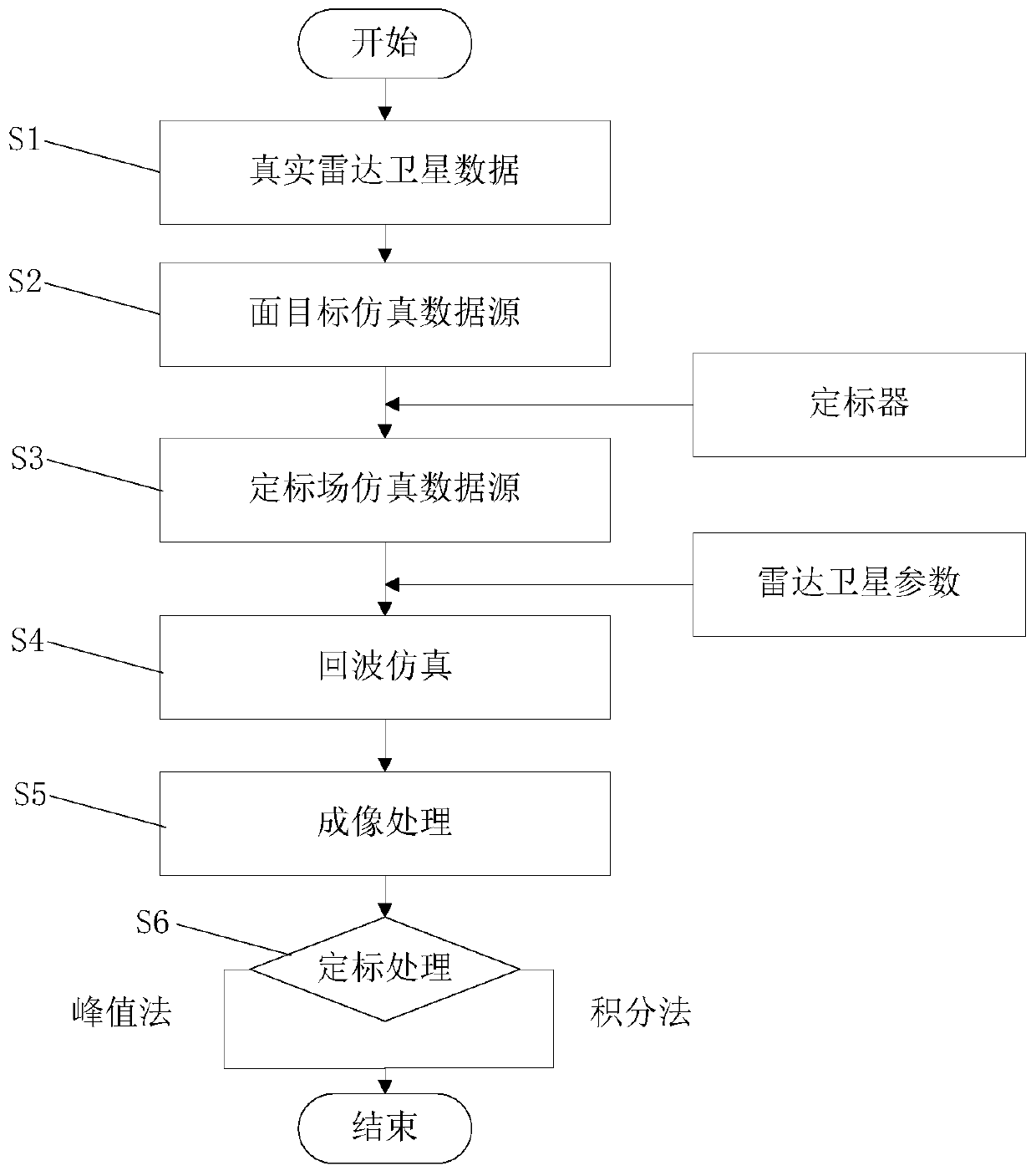
[0091] Such as figure 1 As shown, a high-precision full-link spaceborne SAR radiation calibration simulation method provided by the embodiment of the present invention includes the following steps:

[0092] S1. Read in the real radar satellite data: read in the real radar satellite data of the scene that meets the requirements of the calibration field.

[0093] This step selects real radar satellite image products. Preferably, the scenes read in in step S1 should be uniformly distributed in a sufficiently large range, and the backscattering intensity is weak and does not exceed the threshold, so that after deploying the calibration device, To meet the requirements of high signal-to-clutter ratio, that is, the selected scene should meet the requirements of the general calibration field, and the calibrator can be actually installed.

[0094] S2. Selecting a simulation data source: According to the radar satellite data read in step S1, select an area object whose range and azimu...

Embodiment 2

[0166] Such as Figure 2-Figure 11 As shown, the second embodiment is basically the same as the first embodiment, and the similarities will not be repeated. The difference lies in:

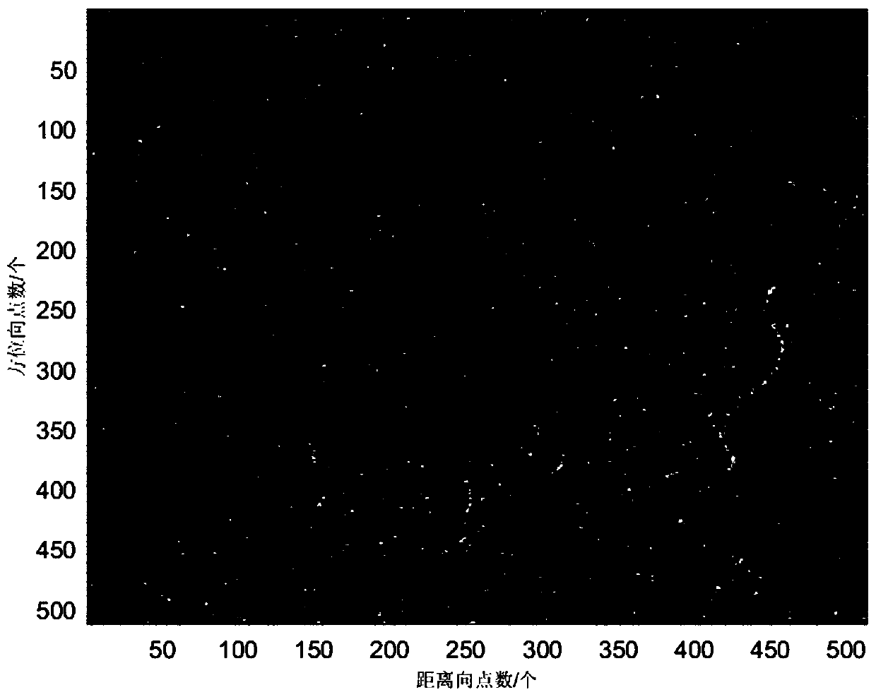
[0167] This embodiment selects the standard strip mode radar image product of the Amazon tropical rainforest imaged by Gaofen No. 3 radar satellite, such as figure 2 shown. Select a surface object with 512 points in both the range direction and the azimuth direction as the calibration simulation data source, such as image 3 shown. The starting position of the target azimuth of this surface is 2300, and the starting position of the range is 6500. The RCS in the calibration simulation area approximates a Gaussian distribution, and the histogram is as follows Figure 4 shown. The average value of RCS in the calibration simulation area is -17.33dB.

[0168] Table 1 Echo simulation parameters

[0169]

[0170] By adding a scaler with a known radar cross-sectional area at the center of the s...


PUM


Abstract

The invention relates to a high-precision full-link spaceborne SAR radiation calibration simulation method. The method comprises steps: real radar satellite data are read; surface targets whose pointnumbers in a distance direction and an azimuth direction meet requirements are selected as a simulation data source for radiation calibration; through adding a scaler with the scatter cross section area of a known radar in the center of a scene, a surface target simulation data source of a layout scaler is constructed; the surface target of the layout scaler is decomposed to multiple point targets, the echoes of the point targets are calculated and superimposed to obtain echo simulation signals; imaging processing is carried out to obtain a scene radar image containing the scaler; and a radiation calibration coefficient is calculated to complete calibration processing. The method provided by the invention adopts real radar satellite data to perform calibration field echo simulation, the problem of high experimental cost of the real layout scaler is solved, and the spaceborne SAR full-link radiation calibration simulation is realized.

Description

technical field [0001] The invention relates to the technical field of signal processing, in particular to a high-precision full-link spaceborne SAR radiation calibration simulation method. Background technique [0002] Since its appearance in the 1950s, after nearly 70 years of development, Synthetic Aperture Radar (SAR) technology has entered a relatively mature stage and has been used in geology, hydrology, agriculture, forestry, cities, It is widely used in marine, surveying and mapping, and military reconnaissance. Early SAR applications mainly obtained target information such as position, shape, graphics, texture and contrast through radar images, which is a qualitative application technology. With the development of the new generation of spaceborne SAR, the correlation technology of the calibrated SAR image is gradually mature, and the radiation quality of the SAR image is gradually improved, which can be directly related to the target radar cross-sectional area or s...

Claims


Application Information

Patent Timeline
IPC IPC(8): G01S7/40
CPCG01S7/4052
Inventor 陈杰章瑞杨威
Owner BEIHANG UNIV
Why Eureka
Try Eureka