
Remote sensing image segmentation method based on disparity map and multi-scale depth network model

A remote sensing image and deep network technology, applied in the field of image processing, can solve problems such as low segmentation accuracy, underutilization, and high noise sensitivity, and achieve the effect of improving segmentation results, improving accuracy, and improving accuracy

Active Publication Date: 2019-08-23
XIDIAN UNIV
View PDF3 Cites 12 Cited by
  • Summary
  • Abstract
  • Description
  • Claims
  • Application Information

AI Technical Summary

Problems solved by technology

This method first uses the convolutional neural network sliding window to extract the local features of the remote sensing image, and then uses the softmax classifier to perform pixel-by-pixel classification to obtain the segmentation results. However, this method still has the disadvantage that only the traditional convolution The network automatically learns image features, does not make full use of the global information and multi-scale information of remote sensing images, and the segmentation accuracy is low; in addition, the traditional segmentation method is very sensitive to noise, and only using the traditional convolutional neural network cannot effectively remove the segmentation The noise in the result, and for the remote sensing image of the overhead perspective, the traditional segmentation method cannot make full use of the three-dimensional information of the ground object, that is, the depth information, which will lead to a decrease in the accuracy of the segmentation result

Method used


Image

  • Remote sensing image segmentation method based on disparity map and multi-scale depth network model
  • Remote sensing image segmentation method based on disparity map and multi-scale depth network model
  • Remote sensing image segmentation method based on disparity map and multi-scale depth network model

Examples


Embodiment Construction

[0034] The present invention will be described in further detail below in conjunction with the accompanying drawings.

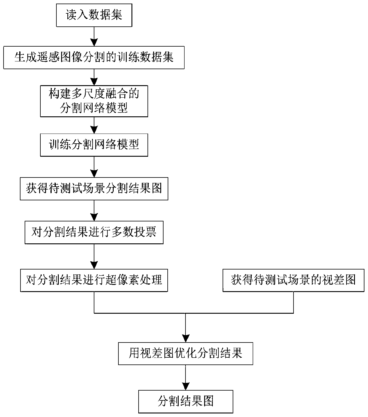
[0035] Reference attached figure 1 , to further describe in detail the implementation steps of the present invention.

[0036] Step 1, read in the dataset.

[0037] Read in the remote sensing image segmentation task dataset consisting of 4292 images, where the size of each image is 1024*1024 pixels, and the dataset includes 5 categories, namely: ground, high vegetation, building, viaduct, water;

[0038] Step 2, obtain the training data set for the remote sensing image segmentation task.

[0039] The specific implementation of this step is as follows:

[0040] 2.1) Count the number of samples of each category in the data set, and perform category balance on the data set, that is, for the category with the smallest amount of data in the data set, select all the pictures containing this type in the data set, and perform different angles on these pictures in ...


PUM


Abstract

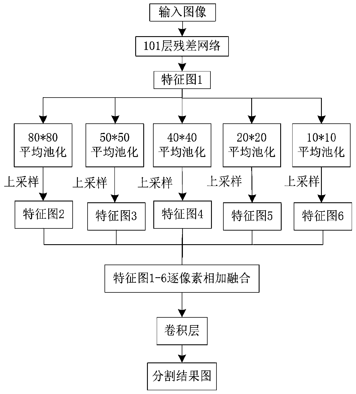
The invention discloses a remote sensing image segmentation method based on a disparity map and a multi-scale deep network model, which mainly solves the problems of low segmentation precision and weak robustness of the existing remote sensing image segmentation method. The implementation scheme includes: reading a data set, and generating a training data set of remote sensing image segmentation;constructing a multi-scale fusion segmentation network model; using the training data set to train a segmentation network model, and storing seven models with different iteration times; obtaining seven different segmentation result graphs by using the stored segmentation network model; carrying out majority voting on the seven different segmentation result graphs, and carrying out super-pixel processing on the voted result graph to obtain a preliminary segmentation result graph; obtaining a disparity map of the test scene by using an SGBM algorithm; and optimizing the preliminary segmentationresult graph by using the disparity map to obtain a final segmentation result. Compared with an existing method, the method has the advantages that the segmentation precision and robustness are obviously improved, and the method can be widely applied to urban and rural planning and intelligent urban construction.

Description

technical field [0001] The invention belongs to the technical field of image processing, in particular to a remote sensing image segmentation method, which can be widely used in urban and rural planning and intelligent urban construction. Background technique [0002] Image segmentation is an important part of image processing, and the quality of its segmentation results will have a great impact on the next step of target recognition, image recognition, scene analysis and other work. With the continuous development of remote sensing technology and the improvement of the resolution of commercial satellites, people pay more and more attention to the research on remote sensing image segmentation technology. Compared with natural images, the shooting height of remote sensing images is higher, which makes it difficult for remote sensing images to reach the resolution level of natural images, so that the accuracy of segmentation algorithms applied to natural images will be greatly...

Claims


Application Information

Patent Timeline
Patent Type & Authority Applications(China)
IPC IPC(8): G06K9/34G06T7/11G06T7/55
CPCG06T7/11G06T7/55G06T2207/10032G06T2207/20081G06T2207/20084G06V10/267
Inventor 焦李成陈洁李晓童张若浛郭雨薇李玲玲屈嵘杨淑媛侯彪
Owner XIDIAN UNIV
Learn More