Long and short term memory network assistance-based satellite positioning method

A long-term memory and satellite positioning technology, applied in the field of information processing, can solve the problem of unable to provide positioning information, and achieve the effect of improving the success rate

Inactive Publication Date: 2019-08-27
浙江融芯导航科技有限公司
View PDF10 Cites 11 Cited by
  • Summary
  • Abstract
  • Description
  • Claims
  • Application Information

AI Technical Summary

Problems solved by technology

Once the receiver is located in a complex environment, the quality of the satellite signal will decline, and it will not be able to provide accurate positioning information.

Method used


Image

  • Long and short term memory network assistance-based satellite positioning method
  • Long and short term memory network assistance-based satellite positioning method
  • Long and short term memory network assistance-based satellite positioning method

Examples


Embodiment Construction

[0050] The following describes a preferred embodiment of the present invention with reference to the accompanying drawings to make its technical content clearer and easier to understand. The present invention can be embodied in many different forms of embodiments, and the protection scope of the present invention is not limited to the embodiments mentioned herein.

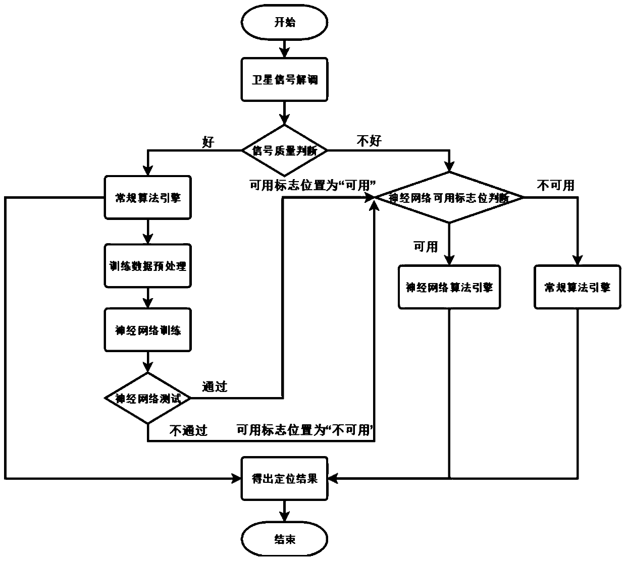
[0051] Such as figure 1 Shown is a logic flow chart of a preferred embodiment of the present invention. A kind of satellite positioning method based on long-short-term memory network assistance that the present invention proposes, specifically comprises the following steps:

[0052] Step 1. Judge the satellite signal quality.

[0053] Step 2. If the quality of the satellite signal is good, the positioning result is given by the conventional algorithm engine, and the neural network is trained and tested using the positioning result obtained from the high-quality satellite signal.

[0054] Step 3. If the satellite...


PUM


Abstract

The invention discloses a long and short term memory network assistance-based satellite positioning method. The method comprises a conventional algorithm engine, a neural network algorithm engine anda usable flag bit of the neural network algorithm engine. The method is characterized in that the conventional algorithm engine is adopted to give a satellite positioning result under a condition thata satellite is favorable in signal, and the satellite positioning result is utilized to train and test a neural network. When a receiver is located under a complicated condition, if the neural network algorithm engine is trained and can be used, the neural network algorithm engine is used for predicting the positioning result. The method is capable of utilizing the trained neural network to predict the coordinate of the receiver when the performance of the conventional algorithm engine is greatly reduced, so as to improve the satellite positioning success rate.

Description

technical field [0001] The invention relates to the technical field of information processing, in particular to a satellite positioning method assisted by a long-short-term memory network. Background technique [0002] GNSS (global navigation satellite system) is a general term for a class of navigation systems that use in-orbit satellites to transmit radio signals for passive ranging and positioning. GNSS is a self-positioning system, that is, the positioning solution is calculated in the navigation device, and the calculated positioning position result does not need to transmit any signal. [0003] In the 1960s, the United States established the world's first satellite navigation system, the Meridian satellite navigation system, which was mainly used for ship navigation and operated until 1996. Then Russia also established a similar system - San Kada satellite navigation system. In 1978, the first operational satellite of the US Global Positioning System (GPS) was succes...

Claims


Application Information

Patent Timeline
Patent Type & Authority Applications(China)
IPC IPC(8): G01S19/43G06N3/04G06N3/08
CPCG01S19/43G06N3/08G06N3/044G06N3/045
Inventor 高迪何文涛蔺晓龙翟昆朋冯木榉
Owner 浙江融芯导航科技有限公司
Why Eureka
Try Eureka