Vertical line deviation measurement and verification method based on GNSS satellite position observation

A technology of vertical line deviation and verification method, which is applied in radio wave measurement system, satellite radio beacon positioning system, measurement device, etc., can solve the problem of small positioning accuracy of stars, reduce work intensity, achieve easy realization, and improve measurement speed effect

Active Publication Date: 2019-08-30
INST OF OPTICS & ELECTRONICS - CHINESE ACAD OF SCI
View PDF6 Cites 6 Cited by
  • Summary
  • Abstract
  • Description
  • Claims
  • Application Information

AI Technical Summary

Problems solved by technology

[0003] The main basis for the measurement of astronomical measurement is that the theoretical position accuracy of stars is high. In theory, the position accuracy of stars is far less than 0.1″. Less than the theoretical accuracy, so the measurement of the vertical line deviation requires a long time of engineering work and data processing operations to remove random errors and achieve the purpose of high-precision measurement

Method used


Image

  • Vertical line deviation measurement and verification method based on GNSS satellite position observation
  • Vertical line deviation measurement and verification method based on GNSS satellite position observation
  • Vertical line deviation measurement and verification method based on GNSS satellite position observation

Examples


Embodiment Construction

[0021] The present invention will be further described below in conjunction with the accompanying drawings and specific embodiments.

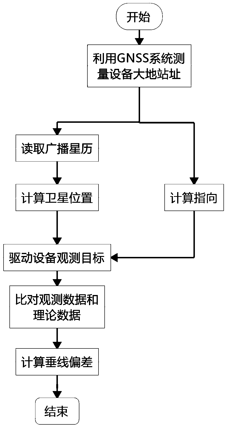
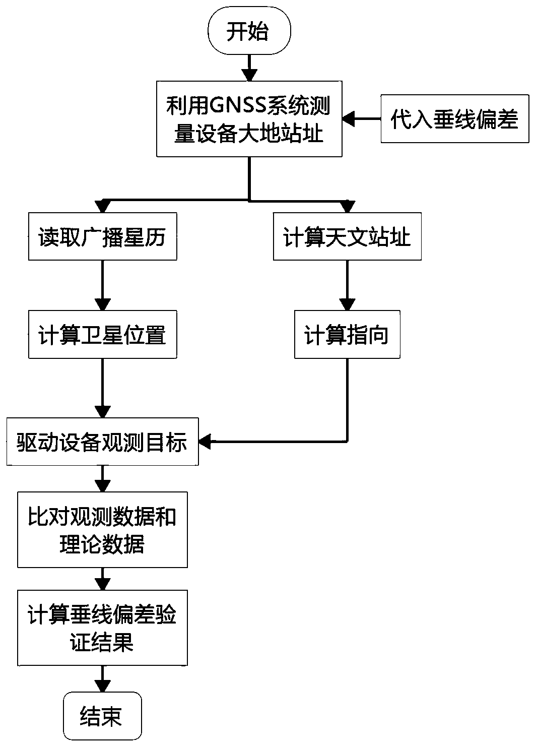
[0022] Such as Figure 1-2 Shown, a kind of vertical deviation measurement and verification method based on GNSS satellite position observation, this method comprises the following steps:

[0023] Step (1), at first determine the geodetic site of the photoelectric equipment location by GNSS system, its data has: longitude L, latitude B and elevation H;

[0024] Step (2), read the GNSS system broadcast ephemeris data, and select observable GNSS satellites (including GPS satellites, Glonass satellites, Galileo satellites or Beidou satellites, etc.), and calculate the satellites in the geocentric coordinate system according to the current time The position of the satellite in the horizon system of the optoelectronic equipment is calculated according to the geodetic station site. When the vertical line deviation needs to be verified, the position ...


PUM


Abstract

The present invention provides a vertical line deviation measurement and verification method based on GNSS satellite position observation, and mainly relates to the field of photoelectric tracking measurement, and high-precision measurement and calibration. For the photoelectric tracking measurement data, the vertical line deviation of the device position needs to be corrected to achieve the purpose of high-precision measurement. The method can be characterized in that: firstly a geodetic site of an optoelectronic device is measured through a GNSS system, then the position of the GNSS system satellite (including the GPS satellite, the Glonass satellite, the Galileo satellite or the Beidou satellite, etc.) is observed, and position guidance numbers generated by the GNSS satellite broadcastephemeris are compared to measure the vertical line deviation. At the same time, the method can also be characterized in that: under the condition of obtaining the vertical line deviation data, the GNSS is used to locate the geodetic site of the optoelectronic device, then the GNSS satellite broadcast ephemeris is used to calculate guidance data of the optoelectronic device for position observation, and observation results are compared to verify the correctness of the vertical line deviation.

Description

technical field [0001] The invention belongs to the field of photoelectric tracking measurement, in particular to a vertical line deviation measurement and verification method based on GNSS satellite position observation. Background technique [0002] In the field of photoelectric tracking measurement, in order to obtain high-precision measurement data of the target position—especially in the target intersection measurement, it is necessary to correct the vertical line deviation of the equipment position. The magnitude of the vertical line deviation is generally on the order of 10″, and the maximum error is 1′. In order to obtain the vertical line deviation of the position of the photoelectric equipment, it is necessary for the geodetic surveyors to use high-precision surveying and mapping equipment to observe and process the data of high-precision stars. But at this stage, although There are many methods to measure vertical deviation, but the method that can really achieve ...

Claims


Application Information

Patent Timeline
Patent Type & Authority Applications(China)
IPC IPC(8): G01S19/40
CPCG01S19/40
Inventor 张涯辉陈科王宗友罗一涵钟代均李锦英任戈
Owner INST OF OPTICS & ELECTRONICS - CHINESE ACAD OF SCI
Why Eureka
Try Eureka