Map-assisted inertial pre-integral pedestrian navigation method

A pedestrian navigation and pre-integration technology, applied in the field of inertial pre-integration pedestrian navigation, can solve problems such as poor correction effect, decreased accuracy, and inability to reflect the real situation.

Active Publication Date: 2019-09-06
NANJING UNIV OF AERONAUTICS & ASTRONAUTICS
View PDF9 Cites 5 Cited by
  • Summary
  • Abstract
  • Description
  • Claims
  • Application Information

AI Technical Summary

Problems solved by technology

[0003] At present, most pedestrian navigation technologies are based on Kalman filter and its derivative technology. The solution process is to find the optimal solution at the current moment, but it is not the case of global optimality.
At the same time, since the inertial device is a purely autonomous sensor, it cannot accept external sign

Method used


Image

  • Map-assisted inertial pre-integral pedestrian navigation method
  • Map-assisted inertial pre-integral pedestrian navigation method
  • Map-assisted inertial pre-integral pedestrian navigation method

Examples


Embodiment Construction

[0080] The technical solutions of the present invention will be described in detail below in conjunction with the accompanying drawings.

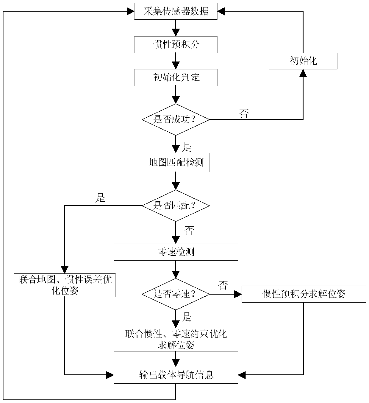
[0081] The present invention designs a map-assisted inertial pre-integration pedestrian navigation method, such as figure 1 As shown, the inertial sensor is fixed on the pedestrian foot carrier, and the inertial sensor includes a gyroscope and an accelerometer. It is characterized in that the steps are as follows:

[0082] Step 1: Periodically collect accelerometer data and gyroscope data at time k;

[0083] Step 2: Use the inertial sensor measurement data obtained in step 1 to pre-integrate and predict the navigation information of the carrier at time k, and obtain the pre-integrated predicted value;

[0084] Step 3: Determine whether the navigation system is initialized. If not, initialize it to obtain the bias of the inertial sensor and the estimated value of the gravity component, and jump to step 1; if it has been initialized, go to s...


PUM


Abstract

The present invention discloses a map-assisted inertial pre-integral pedestrian navigation method. Data of an accelerometer and data of a gyroscope at moment k are collected periodically. Navigation information of a carrier at moment k is predicted using the obtained data pre-integral measured by an inertial sensor. It is determined whether an navigation system has been initialized. If yes, the map matching detection is performed. If the matching succeeds, overall optimization of poses is performed on a unity map and an inertial error and navigation information of the carrier is output. If thematching fails, zero-speed detection is performed. If a zero-speed does not exist, an inertial pre-integral solution pose is performed. If the zero-speed exists, the inertial error and the zero-speedconstrained optimization solution pose are united to output the navigation information of the carrier. The present invention, using the value measured by the inertial sensor, performs the pre-integral optimization solution to output the pedestrian navigation information and carries out the zero-speed constrained correction and optimization. Moreover, map information is imported for optimizing overall traces and removing cumulative errors.

Description

technical field [0001] The invention belongs to the technical field of pedestrian navigation, and in particular relates to an inertial pre-integration pedestrian navigation method. Background technique [0002] Pedestrian navigation technology is a major research and application hotspot in the field of navigation technology in today's society and life. Inertial sensors can be sensitive to their own rotational angular velocity and acceleration information, have extremely high autonomy and anti-interference, and can be applied in various complex environments. It is a technology with broad development prospects and great application potential in the field of navigation. [0003] At present, most pedestrian navigation technologies are based on Kalman filter and its derivative technology. The solution process is to obtain the optimal solution at the current moment, but it is not the case of global optimality. At the same time, since the inertial device is a purely autonomous sen...

Claims


Application Information

Patent Timeline
IPC IPC(8): G01C21/16G01C21/00G01C25/00
CPCG01C21/005G01C21/16G01C25/005
Inventor 袁诚吕品赖际舟朱超群杨子寒何容
Owner NANJING UNIV OF AERONAUTICS & ASTRONAUTICS
Why Eureka
Try Eureka