
A method for engineering survey data processing oriented to the whole life cycle of geotechnical engineering

A full-life-cycle, engineering survey technology, applied in image data processing, electrical digital data processing, special data processing applications, etc., can solve problems that cannot meet the multi-level requirements of geotechnical engineering geological information, and achieve the benefits of survey efficiency and Accuracy of results, avoiding conversion loss, and improving accuracy

Active Publication Date: 2020-10-30
CHINA UNIV OF GEOSCIENCES (WUHAN)
View PDF10 Cites 0 Cited by
  • Summary
  • Abstract
  • Description
  • Claims
  • Application Information

AI Technical Summary

Problems solved by technology

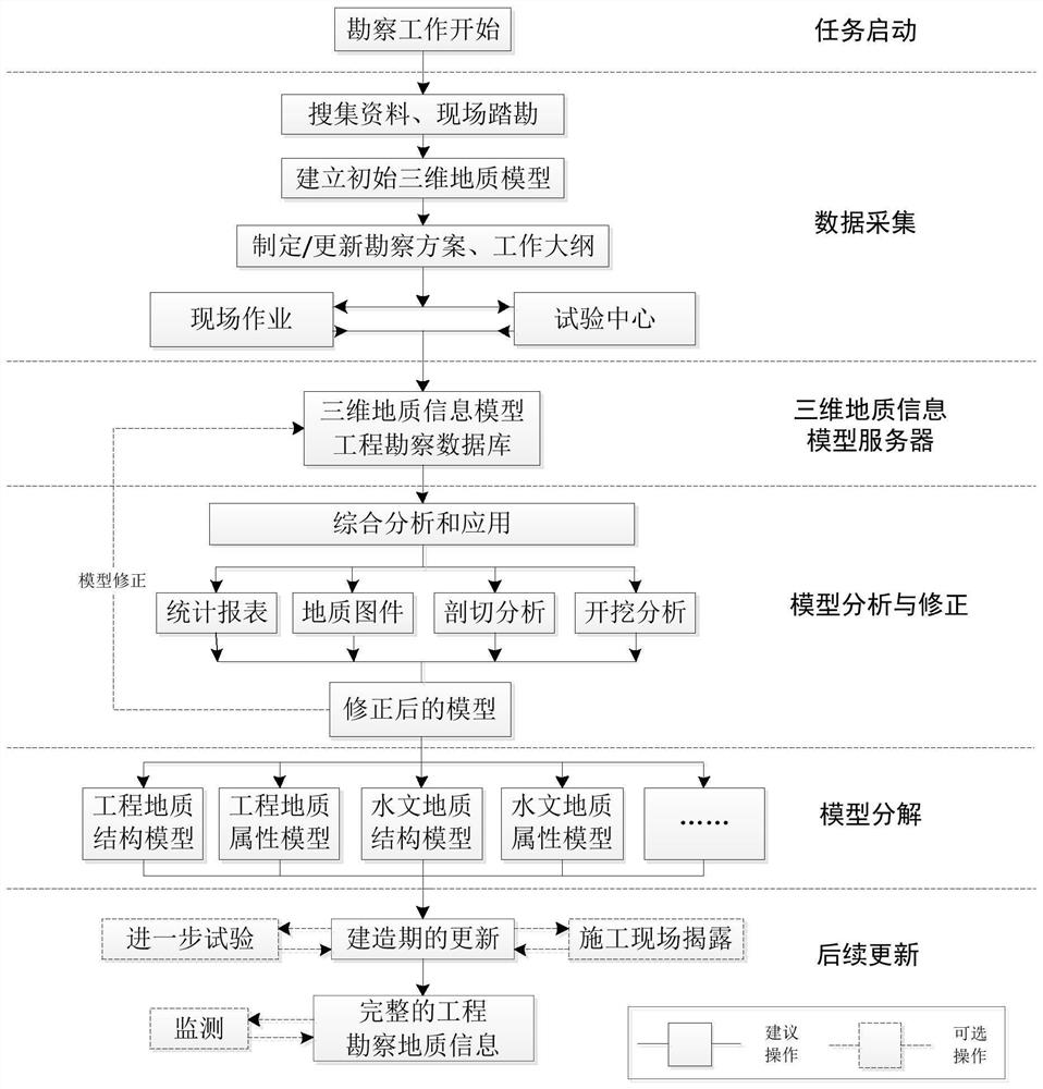
[0004] Aiming at the problem that the results of engineering geological survey are out of touch with the requirements for geological information in the whole life cycle of geotechnical engineering, and cannot meet the multi-level needs of geological information for all parties involved in geotechnical engineering, the present invention proposes a method for information processing of the entire process of engineering geological survey In order to improve the utilization degree of engineering geological survey information in the planning, design, construction, management and other stages of geotechnical engineering, this method can also improve the work efficiency of the whole process of engineering geological survey

Method used


Image

  • A method for engineering survey data processing oriented to the whole life cycle of geotechnical engineering
  • A method for engineering survey data processing oriented to the whole life cycle of geotechnical engineering
  • A method for engineering survey data processing oriented to the whole life cycle of geotechnical engineering

Examples


Embodiment Construction

[0018] In order to have a clearer understanding of the technical features, purposes and effects of the present invention, the specific implementation manners of the present invention will now be described in detail with reference to the accompanying drawings.

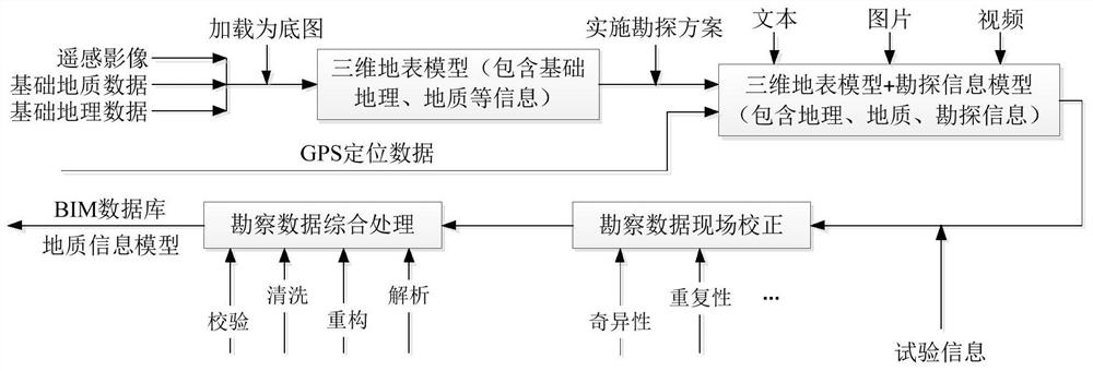
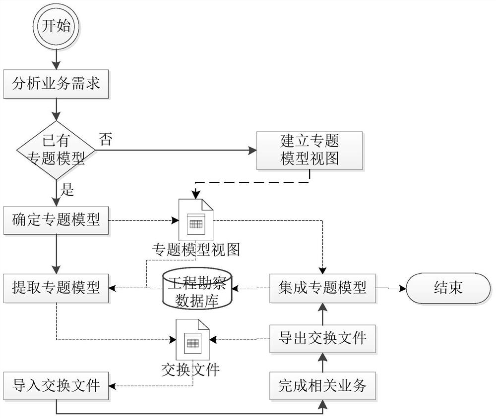
[0019] The present invention uses artificial intelligence and mobile Internet technology to improve the accuracy and convenience of engineering survey data collection, uses a method of combining relational and non-relational databases to manage engineering survey data, and uses a method of multi-field information coupling to establish a three-dimensional engineering geological model. The 3D geological information model is combined with the survey database to construct a 3D information model server for engineering geology. Based on the model server, 3D geological analysis and application are carried out, and thematic models are extracted from it to meet the needs of geological information at various stages of geotechnical ...


PUM


Abstract

The invention discloses an engineering survey data processing method oriented to the whole life cycle of geotechnical engineering. The invention uses information technology to transform the whole process of engineering survey, and uses artificial intelligence and mobile Internet technology to improve the accuracy and accuracy of engineering survey data collection. Convenience, using the method of combining relational and non-relational databases to manage engineering survey data, using the method of multi-field information coupling to establish engineering geological 3D models, combining 3D geological models and survey databases to build engineering geological 3D information model servers, based on The model server conducts 3D geological analysis and application, and extracts thematic models from it to meet the needs of geological information at various stages of geotechnical engineering. The invention is beneficial to the improvement of survey efficiency and accuracy of results, can transmit survey results to different stages of geotechnical engineering implementation to the greatest extent, and improves the utilization value of survey results.

Description

technical field [0001] The invention belongs to the technical field of engineering geological survey, and in particular relates to an engineering survey data processing method for the whole life cycle of geotechnical engineering. Background technique [0002] Different stages of the life cycle of geotechnical engineering (planning, design, construction, operation and maintenance) have different requirements for engineering geological survey information. Using information technology to transform the processing method of engineering geological survey data can improve the processing efficiency of engineering survey data , so as to meet the multi-level needs of geological information in the whole life cycle of civil engineering. Chinese utility model patent CN201120047999.7 discloses a real-time acquisition device for drilling process data of a down-the-hole drilling rig. By refitting the drilling rig, the automatic collection of data during the drilling process can be realized...

Claims


Application Information

Patent Timeline
Patent Type & Authority Patents(China)
IPC IPC(8): G06F30/13G06F30/27G06F16/28G06F16/248G06F16/2458G06T17/05
CPCG06F16/284G06F16/28G06F16/248G06F16/2462G06T17/05G06F30/20G06F30/13
Inventor 张军强张志庭刘刚何珍文翁正平李章林陈麒玉
Owner CHINA UNIV OF GEOSCIENCES (WUHAN)
Learn More