A Map Matching Method Based on Multi-sensor Data and Angle Feature Recognition

A multi-sensor, map-matching technology, applied to road network navigators and other directions, can solve problems such as random errors and systematic errors, and achieve the effects of reducing complexity, reducing observation errors, and facilitating manipulation

Active Publication Date: 2020-11-24
HUAZHONG UNIV OF SCI & TECH
View PDF11 Cites 2 Cited by
  • Summary
  • Abstract
  • Description
  • Claims
  • Application Information

AI Technical Summary

Problems solved by technology

[0005] However, further research shows that for this kind of reflectorless navigation method, due to the systematic error of each device or sensor, and the random error caused by the complexity of the environment, the accuracy of this SLAM navigation method has become the primary problem to be solved. question

Method used


Image

  • A Map Matching Method Based on Multi-sensor Data and Angle Feature Recognition
  • A Map Matching Method Based on Multi-sensor Data and Angle Feature Recognition
  • A Map Matching Method Based on Multi-sensor Data and Angle Feature Recognition

Examples


Embodiment Construction

[0036] In order to make the object, technical solution and advantages of the present invention clearer, the present invention will be further described in detail below in conjunction with the accompanying drawings and embodiments. It should be understood that the specific embodiments described here are only used to explain the present invention, not to limit the present invention. In addition, the technical features involved in the various embodiments of the present invention described below can be combined with each other as long as they do not constitute a conflict with each other.

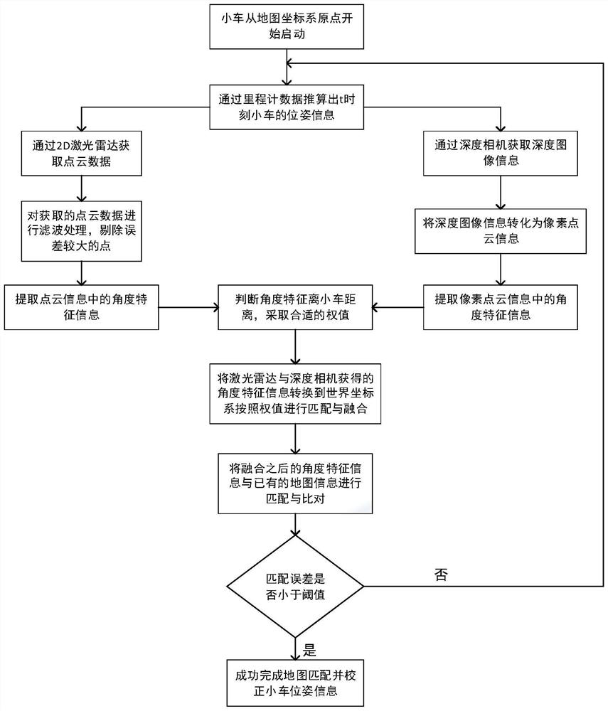
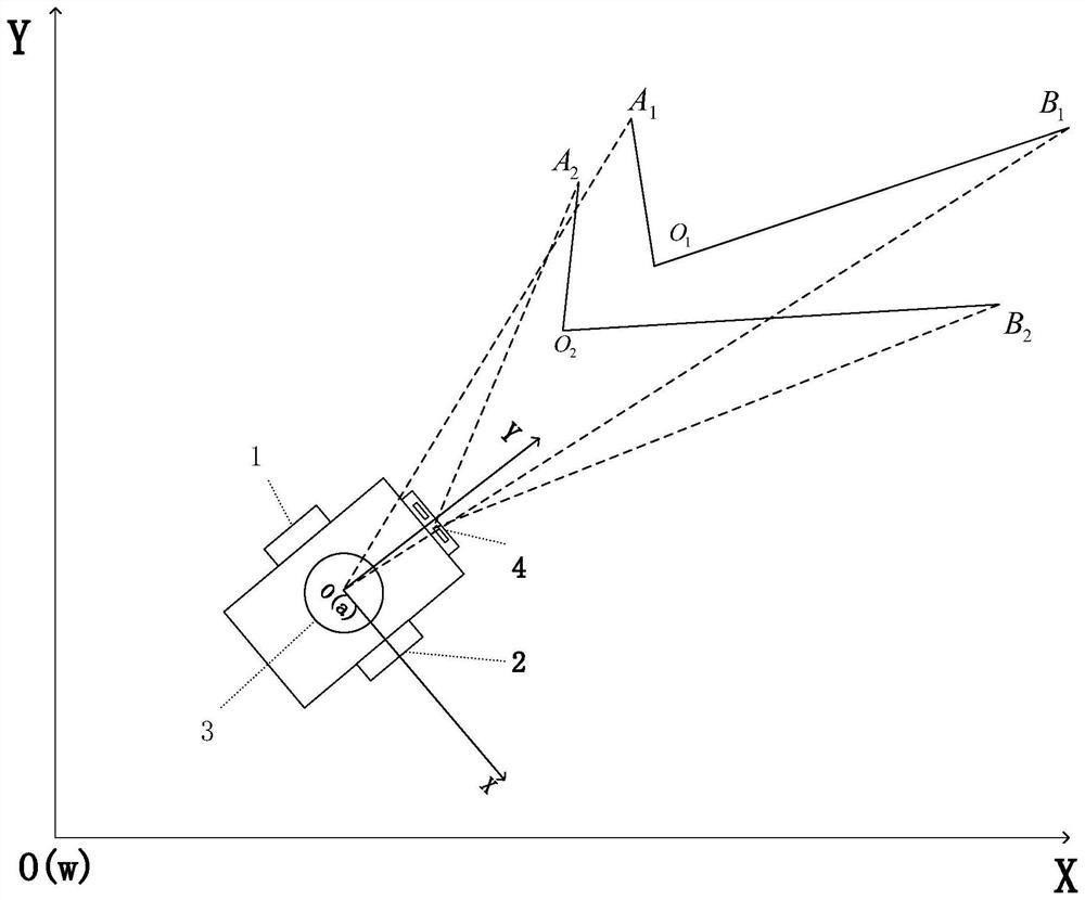
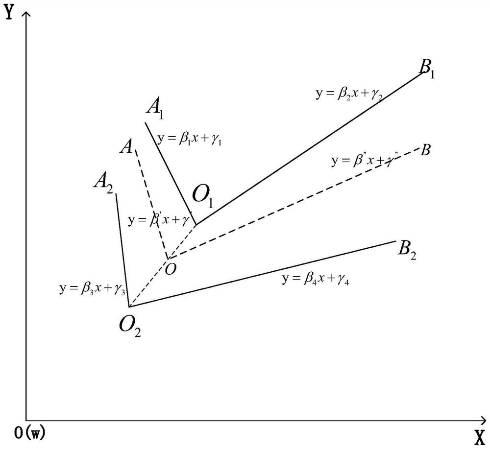
[0037] figure 1 It is an overall process flow chart of the map matching method based on multi-sensor data and angle feature recognition constructed according to the present invention, figure 2 It is a map matching application specific scene graph displayed according to a preferred embodiment of the present invention. Such as figure 1 with figure 2 As shown, the method mainly includes the...


PUM


Abstract

The invention belongs to the related field of instant positioning and map construction of a mobile object, and discloses a map matching method based on multi-sensor data and angle characteristic identification. The method comprises the following steps of acquiring real-time pose information through an odometer; respectively acquiring angle characteristic information through a laser radar and a depth vision camera; and performing map matching after fusing the different angle characteristic information. According to the method, the multiple sensors can be mutually fused, respective errors are mutually compensated, a high-accuracy map element matching method based on simple angle characteristics is realized, drift errors caused by the odometer are corrected in real time, and the positioning accuracy of an unmanned trolley is improved.

Description

technical field [0001] The invention belongs to the field of real-time positioning of moving objects and map construction, and more specifically relates to a map matching method based on multi-sensor data and angle feature recognition. Background technique [0002] With the improvement of industrial automation technology and the requirements for production efficiency, more and more companies are beginning to use mobile robots such as unmanned vehicles to replace manual handling in warehousing and logistics transportation to improve transportation efficiency and reduce costs. The prerequisite for the automatic handling of unmanned vehicles in the warehouse area is to be familiar with the environment of the warehouse area and to be able to realize the functions of real-time positioning and automatic navigation. In this case, whether the autonomous positioning and high-precision navigation of unmanned vehicles can be realized The key to complete automatic handling. [0003] Th...

Claims


Application Information

Patent Timeline
Patent Type & Authority Patents(China)
IPC IPC(8): G01C21/30
CPCG01C21/30
Inventor 陈建魁曹小川李益群
Owner HUAZHONG UNIV OF SCI & TECH
Why Eureka
Try Eureka