Road passable area detection method based on three-dimensional laser radar

A three-dimensional laser, passing area technology, applied in the field of unmanned environment perception, can solve problems such as lack of universality, and achieve the effect of accurate surrounding environment information, good real-time performance, and reduced calculation amount

Pending Publication Date: 2019-09-17
WUHAN UNIV OF TECH
View PDF6 Cites 37 Cited by
  • Summary
  • Abstract
  • Description
  • Claims
  • Application Information

AI Technical Summary

Problems solved by technology

[0004] In the method based on the original point cloud, the invention patent with the patent number CN201810169285.X "A method for extracting the feasible region of structured roads based on 3D laser radar", and the invention patent with the patent number CN201810027774.1 "A method based on 3D laser The real-time road segmentation method of radar" is to extract the single-line point cloud from the multi-line lidar, and take the single-line point cloud as the

Method used


Image

  • Road passable area detection method based on three-dimensional laser radar
  • Road passable area detection method based on three-dimensional laser radar
  • Road passable area detection method based on three-dimensional laser radar

Examples


Embodiment Construction

[0033] The present invention will be further described below in conjunction with specific examples and accompanying drawings.

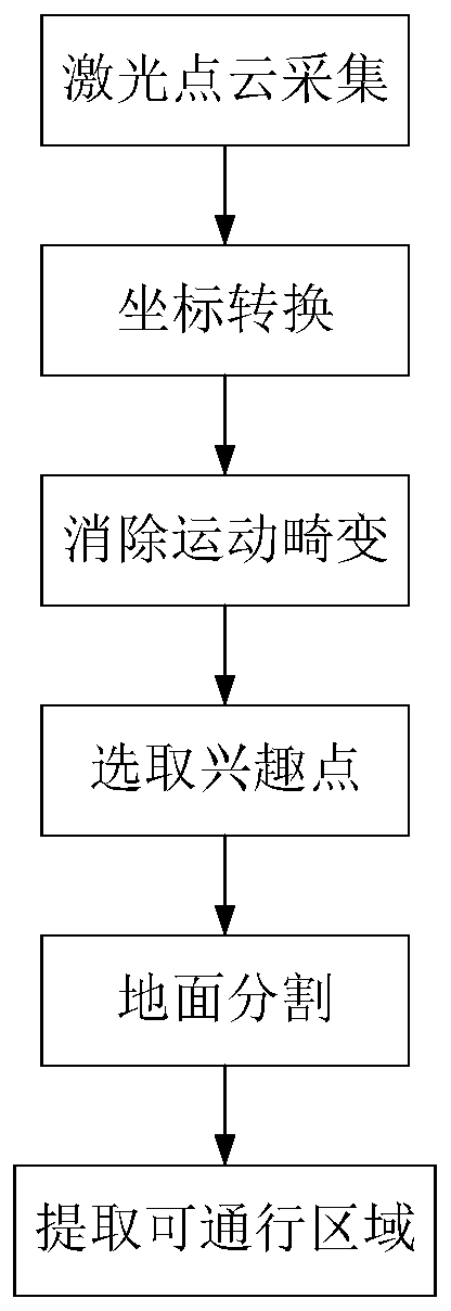
[0034] The present invention provides a method for detecting the passable area of ​​a road based on a three-dimensional laser radar, such as figure 1 shown, including the following steps:

[0035] S1. Use the 3D lidar to obtain the surrounding environment information of the vehicle, and convert the collected point cloud data from the lidar coordinate system to the vehicle coordinate system.

[0036] The laser radar is installed on the top of the vehicle. The coordinate information of the collected laser point cloud is based on the coordinate system established by the laser radar installation position as the coordinate origin O, and the forward direction of the vehicle is used as the X-axis direction of the laser radar coordinate system, which is parallel to the horizontal plane of the laser radar. The direction perpendicular to the X-axis is the Y-ax...


PUM


Abstract

The invention provides a road passable area detection method based on three-dimensional laser radar. The road passable area detection method comprises the steps of: obtaining surrounding information of a vehicle by adopting three-dimensional laser radar, and collecting point cloud data; eliminating the motion distortion of the point cloud by combining the odometer information of the vehicle; extracting laser point cloud interest points according to the point cloud data after motion distortion is eliminated, wherein extracting laser point cloud interest points mainly comprises rejecting data points located out of an area at a certain height above the laser radar; performing ground segmentation by adopting the height information of the extracted laser point cloud interest points and combining the RANSAC algorithm, and distinguishing the ground point cloud and the obstacle point cloud; and rasterizing the distinguished obstacle point cloud, extracting data points closest to the vehicle in each grid, and combining the data points to obtain boundary points of the passable area. According to the invention, the problem of motion distortion generated during the motion of the point cloud is eliminated, so that the surrounding information expressed by the point cloud is more accurate.

Description

technical field [0001] The invention belongs to unmanned driving environment perception technology, in particular to a method for detecting a passable area of ​​a road based on a three-dimensional laser radar. Background technique [0002] Unmanned driving technology mainly includes environment perception, path planning and path tracking, among which environment perception is to use on-board sensors such as millimeter wave radar, camera and laser radar to perceive the surrounding information of the vehicle, so as to prepare for path planning and path tracking. In the sensor, the millimeter-wave radar cannot recognize the details of the object, and the recognition effect of the camera will be significantly affected in dark or backlight conditions, while the lidar can measure the details of the object and is not affected by the ambient light, so the lidar is in the environment perception It is widely used in the field and has a complementary effect with other sensors. [0003...

Claims


Application Information

Patent Timeline
IPC IPC(8): G01S17/93G01S7/41
CPCG01S7/41G01S17/931
Inventor 冯智勇黄世健裴晓飞周维刘志厅陈斌
Owner WUHAN UNIV OF TECH
Why Eureka
Try Eureka