Factor graph-based cluster satellite collaborative navigation method

A collaborative navigation and satellite navigation technology, which is applied to satellite radio beacon positioning systems, measuring devices, instruments, etc., can solve the problems of unspecified introduction factor map navigation optimization algorithm, large amount of calculation, data association, etc., to save time cost, reduce the amount of calculation, and improve the effect of navigation accuracy

Active Publication Date: 2019-09-24
NAT INNOVATION INST OF DEFENSE TECH PLA ACAD OF MILITARY SCI
View PDF7 Cites 3 Cited by
  • Summary
  • Abstract
  • Description
  • Claims
  • Application Information

AI Technical Summary

Problems solved by technology

However, it simply expounds the factor graph navigation framework, and does not specifically introduce the factor graph navigation optimization algorithm; on the other hand, the invention does

Method used


Image

  • Factor graph-based cluster satellite collaborative navigation method
  • Factor graph-based cluster satellite collaborative navigation method
  • Factor graph-based cluster satellite collaborative navigation method

Examples


Embodiment Construction

[0033] The present invention will be further described below in conjunction with the accompanying drawings. Apparently, the enumerated examples are only used to explain the present invention, not to limit the scope of the present invention.

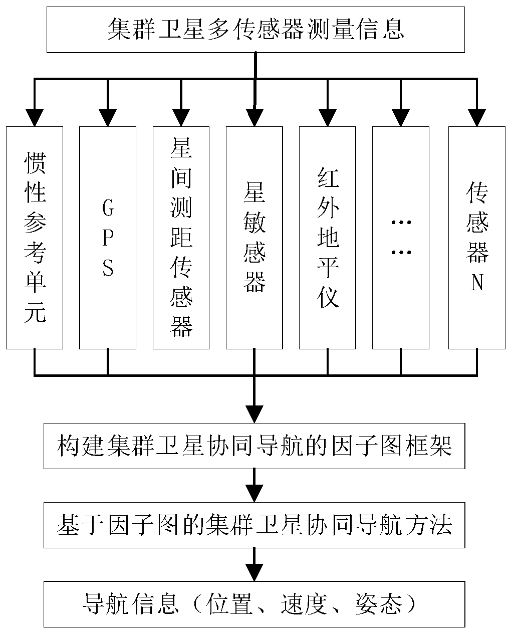
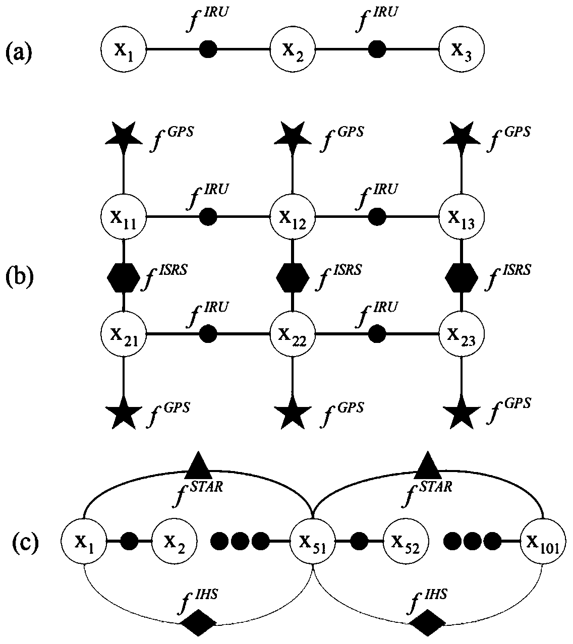
[0034] Such as figure 1 Shown, a kind of cluster satellite cooperative navigation method based on factor graph described in the present invention, comprises the following steps:

[0035] 1. It is assumed that the cluster satellite formation has m sub-satellites, and each sub-satellite has n sensors; during the movement of the cluster satellites, the set of measured values ​​obtained from multiple sensors is i=1,2,...,m,j=1,2,...n, where, Indicates the measurement information of the j-th sensor of the i-th satellite, and the obtained multi-sensor measurement values ​​are m×n;

[0036]There are many types of navigation elements that cluster satellites can use in the factor graph framework, such as GPS, accelerometers, gyroscopes, magne...


PUM


Abstract

The invention relates to a factor graph-based cluster satellite collaborative navigation method. The method comprises the following steps that: the multi-sensor measurement information of each sub-satellite in cluster satellites is acquired; the factor graph framework of cluster satellite collaborative navigation is constructed by means of a factor graph theory; and finally a multi-source information collaborative navigation algorithm is designed so as to calculate navigation information. According to the factor graph-based cluster satellite collaborative navigation method of the invention, existing satellite sensors including an inertial reference unit (IRU), a GPS (global positioning system), an inter-satellite distance measuring sensor, a star sensor, an infrared horizon sensor and the like are adopted; the sensors can be randomly recombined; the factor graph theory and the multi-source information collaborative navigation algorithm are effectively combined; the processing of asynchronous multi-rate measurement information is realized; real-time navigation information can be provided for the cluster satellites quickly and accurately; and a certain technical support can be provided for the research field of aerospace and the like.

Description

technical field [0001] The invention relates to a cluster satellite cooperative navigation method based on a factor graph, which can provide certain technical support for aerospace and other research fields, and belongs to the technical field of spacecraft guidance, navigation and control. Background technique [0002] With the development of satellite application requirements, more and more space missions can no longer be completed by a single satellite, but must rely on the joint work of multiple satellites. And cluster satellites mostly use small satellites or micro-nano satellites. Compared with traditional large satellites, small satellites have low R&D costs, short design cycles, and high functional density. A cluster composed of hundreds or thousands of small satellites has high flexibility and robustness, and can complete tasks that large satellites cannot. At present, satellite constellation and satellite formation flight have been widely accepted by people because...

Claims


Application Information

Patent Timeline
IPC IPC(8): G01S19/42G01S19/47
CPCG01S19/425G01S19/47
Inventor 曹璐肖冰吴西伟冉德超
Owner NAT INNOVATION INST OF DEFENSE TECH PLA ACAD OF MILITARY SCI
Why Eureka
Try Eureka