Automatic on-site and model image synchronization method based on Beidou GNSS and BIM

An automatic synchronization and model technology, applied in photogrammetry/video metrology, gyroscopic effect for speed measurement, gyroscope/steering sensing equipment, etc., can solve the problem of finding the position difficultly, and achieve the effect of meeting the requirements of accuracy and timeliness

Pending Publication Date: 2019-10-18
NANTONG SIJIAN CONSTR GRP
View PDF6 Cites 0 Cited by
  • Summary
  • Abstract
  • Description
  • Claims
  • Application Information

AI Technical Summary

Problems solved by technology

[0002] There are many BIM-based methods for comparing the scene with the model, but the comparison between the scene image and the model requires

Method used


Image

  • Automatic on-site and model image synchronization method based on Beidou GNSS and BIM
  • Automatic on-site and model image synchronization method based on Beidou GNSS and BIM

Examples


Embodiment 1

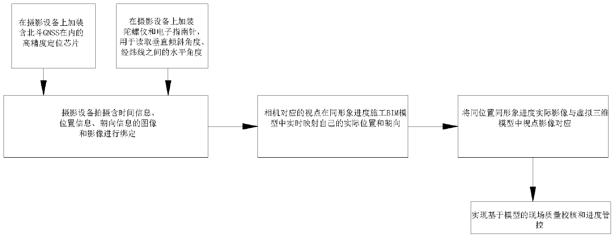
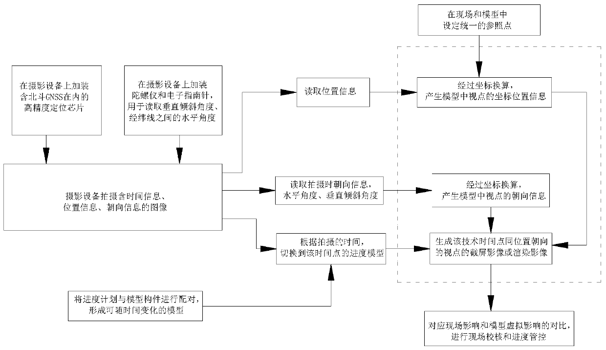
[0033] Such as figure 1 , 2 As shown, an automatic synchronization method of field and model images based on Beidou GNSS and BIM, the specific steps are as follows:

[0034] (1) Install high-precision positioning chips including Beidou GNSS, electronic compass, and gyroscope in the camera;

[0035] (2) When shooting an image, bind the image's position information, orientation vector information, time information and the image;

[0036] (3) The viewpoint corresponding to the camera maps its actual position and orientation in real time in the construction BIM model of the same image progress;

[0037] (4) Correspond the actual images of the same location and image progress with the viewpoint images in the virtual 3D model to realize model-based on-site quality verification and progress control.

[0038] Based on this embodiment, this embodiment can map images captured by GNSS positioning, electronic compass and gyroscope orientation with the construction BIM model in real tim...

Embodiment 2

[0048] The project of an international convention and exhibition center in a city along the coast of my country. The total construction area is about 100,000 square meters. In this project, the construction BIM model of the project was first established, including civil engineering, electromechanical, steel structure and site layout BIM models. Revit software is used to build models for civil engineering and electromechanical disciplines and site layout, Tekla software is used for steel structure disciplines, Rhino software is used for curtain wall disciplines, and the models of the four disciplines and site layout are assembled into one model using Revit software. Complete the establishment of the overall model. And when the model is established, the GNSS reference point position is reflected in the model.

[0049] After the model is established, according to the actual situation on site, match the model components with the schedule, analyze the progress of the project, for...


PUM


Abstract

The invention discloses an automatic on-site and model image synchronization method based on Beidou GNSS and BIM. A high-precision positioning chip including the Beidou GNSS, an electronic compass anda gyroscope are loaded in a camera; during image shooting, position information and orientation vector information of an image are bound with the image; a viewpoint corresponding to the camera maps the own actual position and orientation in real time in a construction BIM model; the actual image corresponding to a viewpoint image in a virtual 3D model at the same position. Therefore, model-basedon-site quality checking and progress control as well as on-site construction management for real-time tracking and management of the on-site construction quality and progress are realized.

Description

technical field [0001] The patent of the invention belongs to the field of building construction management, and in particular relates to a method for automatically synchronizing scene and model images based on Beidou GNSS and BIM. Background technique [0002] There are many BIM-based methods for comparing the scene with the model, but the comparison between the scene image and the model requires manual search for the location. When there are too many images or the scene is relatively similar, finding the location becomes a difficult task. The patent of the present invention is mainly aimed at the synchronous development of the images of the scene and the model. [0003] Since Beidou GNSS can meet the accuracy and timeliness requirements of construction management for object positioning in terms of high-precision and fast positioning, and the electronic compass and gyroscope can meet the vector positioning requirements of camera orientation, they are introduced in this inve...

Claims


Application Information

Patent Timeline
IPC IPC(8): G01C11/00G01S19/01G01C19/00G01C17/00
CPCG01C11/00G01C17/00G01C19/00G01S19/01
Inventor 蔡铭耿裕华张昕张峥峰张卫国徐卓陈亚楠秦璐璐
Owner NANTONG SIJIAN CONSTR GRP
Why Eureka
Try Eureka