Ocean tide correction positioning method and system of satellite-borne GNS-R specular reflection point

A specular reflection and positioning method technology, which is applied in the cross field, can solve the problems of not considering the difference between the ellipsoidal surface and the instantaneous sea surface elevation, and the large positioning error of the specular reflection point, so as to reduce the positioning error and improve the positioning accuracy.

Active Publication Date: 2019-10-25
CHINA ACADEMY OF SPACE TECHNOLOGY
View PDF13 Cites 5 Cited by
  • Summary
  • Abstract
  • Description
  • Claims
  • Application Information

AI Technical Summary

Problems solved by technology

The signal reflection surface of GNSS-R sea surface altimetry is the instantaneous sea surface, but the reflection reference surface closest to the actual sea surface selected by the current mirror reflection point geometric positioning method is the earth ellipsoid, and the elevation between the ellipsoid and the instantaneous sea surface is not considered Difference—Sea Surface Height (SSH), which leads to a large error in the positioning of specular reflection points

Method used


Image

  • Ocean tide correction positioning method and system of satellite-borne GNS-R specular reflection point
  • Ocean tide correction positioning method and system of satellite-borne GNS-R specular reflection point
  • Ocean tide correction positioning method and system of satellite-borne GNS-R specular reflection point

Examples


Embodiment Construction

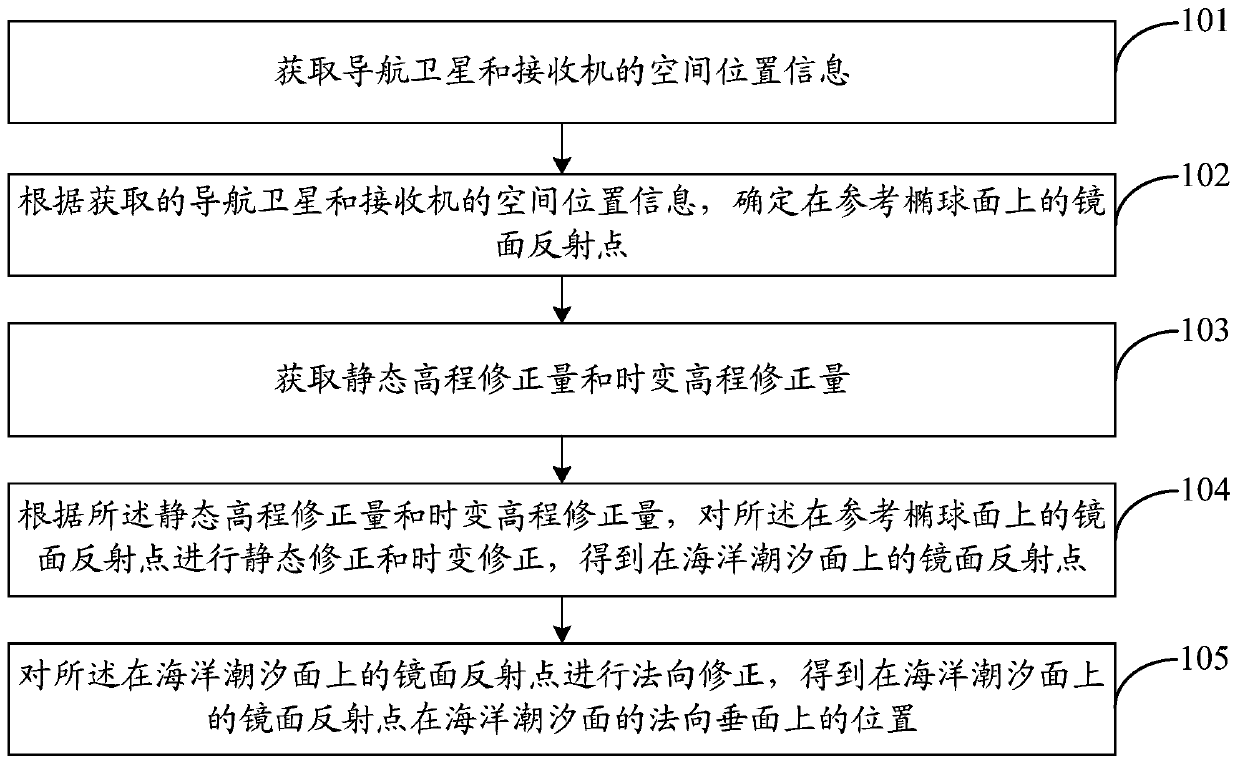
[0060] In order to make the object, technical solution and advantages of the present invention clearer, the embodiments disclosed in the present invention will be further described in detail below in conjunction with the accompanying drawings.

[0061] Such as figure 1 , in this embodiment, the spaceborne GNSS-R specular reflection point ocean tide correction positioning method includes:

[0062] Step 101, acquiring spatial position information of navigation satellites and receivers.

[0063] Step 102: Determine the specular reflection point S on the reference ellipsoid according to the acquired spatial position information of the navigation satellite and the receiver.

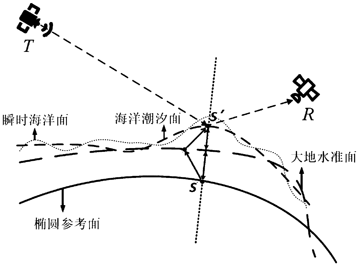
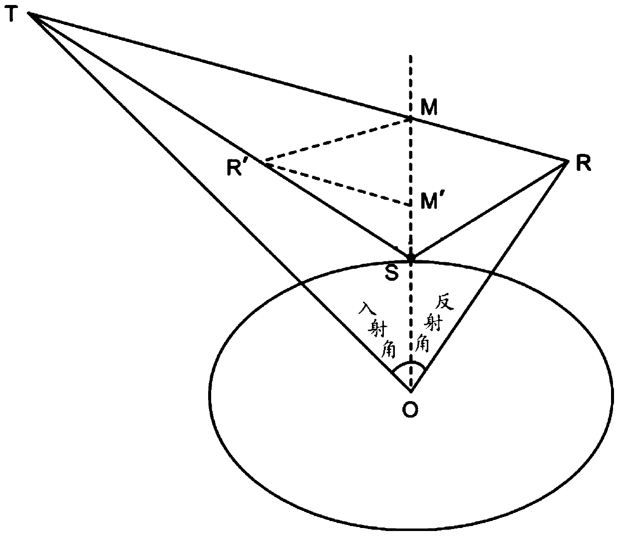
[0064] In this example, if figure 2 with image 3 , according to the acquired spatial position information of the navigation satellite and the receiver, the position vectors of the navigation satellite T, the receiver R, and the mirror reflection point S on the reference ellipsoid can be expressed as: wi...


PUM


Abstract

The invention discloses an ocean tide correction positioning method and system of a satellite-borne GNS-R specular reflection point. The method includes: acquiring spatial position information of a navigation satellite and a receiver; determining a specular reflection point S on a reference ellipsoid according to the obtained spatial position information of the navigation satellite and the receiver; acquiring a static elevation correction amount and a time-varying elevation correction amount; on the basis of the static elevation correction amount and the time-varying elevation correction amount, carrying out static elevation correction and the time-varying elevation correction on the specular reflection point S on the reference ellipsoid to obtain a specular reflection point S'on an oceantidal surface; and carrying out normal correction on the specular reflection point S' on the ocean tidal surface to obtain a position S'of the specular reflection point S'on the ocean tidal surface ona normal vertical plane of the ocean tidal plane. Therefore, the sea surface positioning accuracy of the satellite-borne GNSS-R specular reflection point is improved.

Description

technical field [0001] The invention belongs to the interdisciplinary technical fields of satellite altimetry, ocean gravity, and ocean tides, and in particular relates to a method and system for correcting and positioning ocean tides of satellite-borne GNSS-R mirror reflection points. Background technique [0002] Global navigation satellite signal reflection technology (GNSS-R) is a new generation of sea surface altimetry technology. Its principle is to use the distance difference between the GNSS sea surface reflection signal and the direct signal to reach the receiver to achieve altimetry. Compared with traditional satellite altimeters, GNSS-R altimetry has the advantages of rich signal sources, low payload cost, all-weather, all-time, and low power consumption. Based on multi-channel receivers, multiple sea surfaces can be obtained at the same time Reflected signals, combined with a network of multiple GNSS-R satellites, can achieve high spatial resolution global sea su...

Claims


Application Information

Patent Timeline
IPC IPC(8): G01S19/42G01S19/40
CPCG01S19/40G01S19/42
Inventor 郑伟吴凡李钊伟
Owner CHINA ACADEMY OF SPACE TECHNOLOGY
Why Eureka
Try Eureka