

Geometric positioning precision analysis method for remote sensing satellite without ground control point
A ground control point and geometric positioning technology, which is applied in the field of remote sensing satellite geometric positioning, can solve problems such as strict analysis and calculation of the geometric positioning accuracy of remote sensing satellites in orbit, and achieve the effect of supporting the design and analysis and evaluation of the geometric positioning accuracy of remote sensing satellites.
Active Publication Date: 2019-10-25
CHINA ACADEMY OF SPACE TECHNOLOGY
View PDF2 Cites 12 Cited by
- Summary
- Abstract
- Description
- Claims
- Application Information
AI Technical Summary
Problems solved by technology
However, the calculation is mainly based on empirical values, which can only give a rough range of image positioning accuracy, and is not suitable for strict analysis and calculation of the geometric positioning accuracy of on-orbit remote sensing satellites.
Method used
View moreImage
Smart ImageViewing Examples

Examples
Embodiment
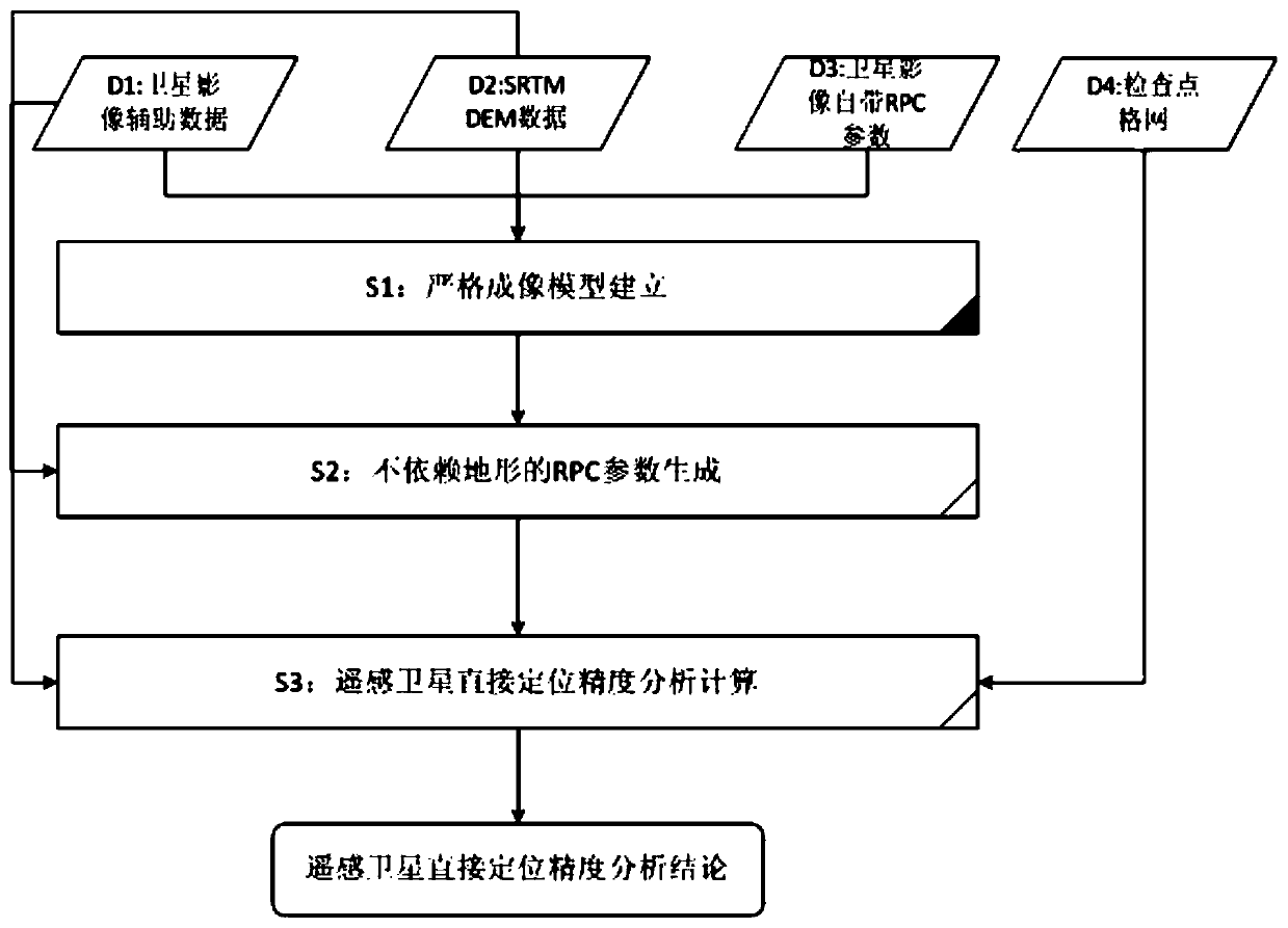
[0096] The overall technical process of this embodiment is as follows figure 1 shown.
Login to View More PUM
 Abstract
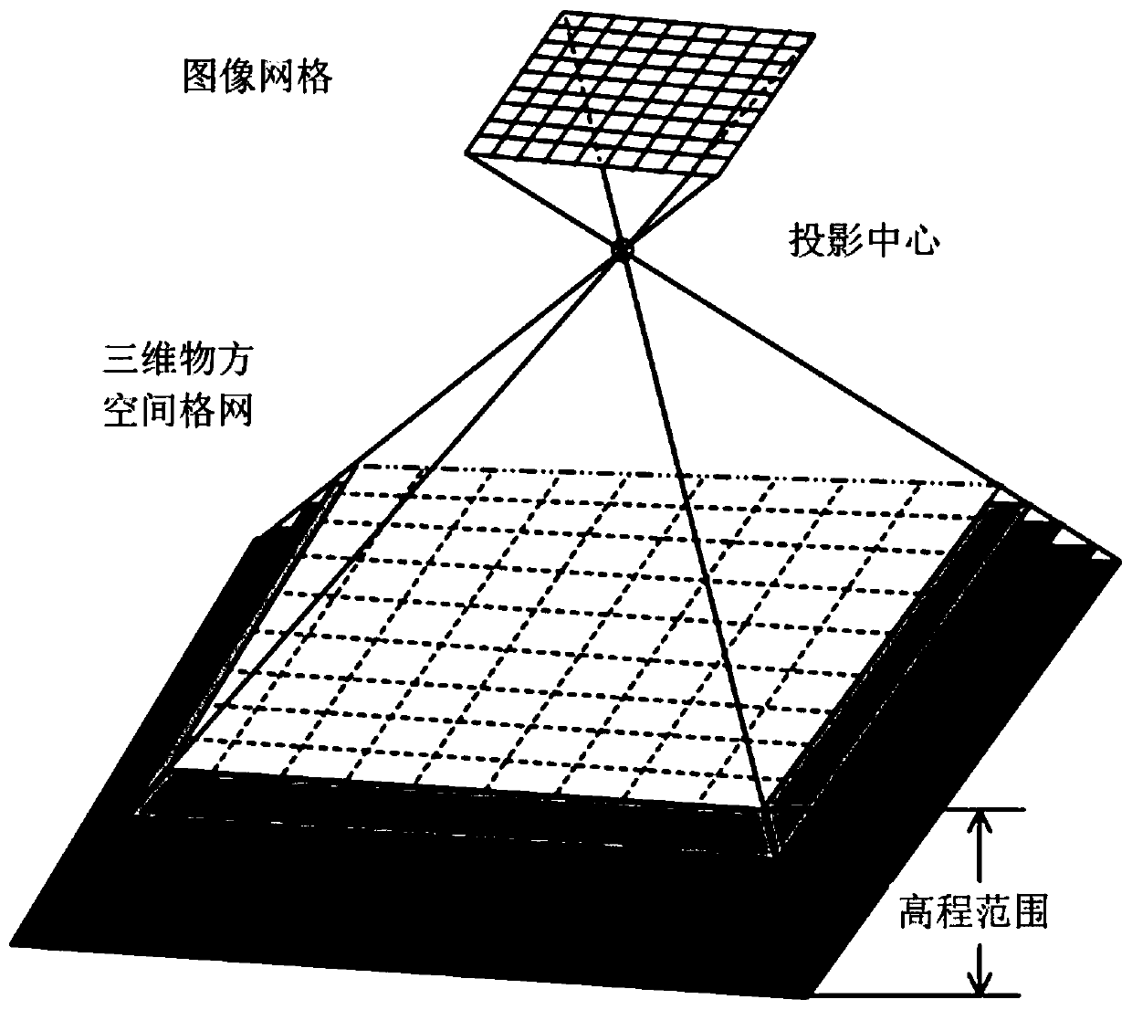
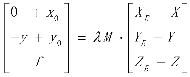
A geometric positioning precision analysis method for a remote sensing satellite without a ground control point comprises the following steps: S1, establishing a strict imaging model, and rewriting the strict imaging model to obtain a strict model geometric positioning equation; S2, generating RPC parameters independent of terrains; S3, checking the absolute geometric positioning precision of theRPC coefficient of the image product according to an image angular point method, and judging whether the RPC coefficient of the image product can be used as the reference data of geometric precision analysis and checking or not; verifying the internal coincidence precision of the RPC coefficient generated without depending on a terrain method according to a check point method, and eliminating errors possibly introduced by RPC coefficient calculation; according to a cross validation method, obtaining the relative precision of the RPC coefficient generated without depending on a terrain method and the RPC coefficient of the image data product; and obtaining a direct geometric positioning precision analysis conclusion of the on-orbit optical remote sensing satellite. According to the method,the analysis and calculation of the geometric positioning precision of the remote sensing satellite are realized.
Description
technical field [0001] The invention belongs to the technical field of geometric positioning of remote sensing satellites, and relates to an analysis and calculation method of geometric positioning accuracy of satellites, which is suitable for analyzing and evaluating the geometric positioning accuracy of on-orbit optical remote sensing satellites. Background technique [0002] The (direct) geometric positioning accuracy of remote sensing satellites is an important index to evaluate the geometric performance of remote sensing satellites, and it is an important basis for evaluating the source of geometric positioning errors of remote sensing images. The traditional geometric correction processing of remote sensing satellites relies on ground control points to eliminate systematic errors and improve the positioning accuracy of remote sensing images. However, the acquisition of ground control points is difficult and inefficient; the number of ground control points is limited af...
Claims
Login to View More Application Information
Patent Timeline
 Patent Type & AuthorityApplications(China)
IPC IPC(8): G06F17/50
CPCG06F30/20
Inventor江志军满益云张嘉雷边福强
OwnerCHINA ACADEMY OF SPACE TECHNOLOGY