Ecological water reserve estimation method based on airborne LiDAR and multispectral remote sensing technology

A remote sensing technology and multi-spectral technology, applied in the field of ecological water storage estimation of airborne LiDAR and multi-spectral remote sensing technology, can solve the problems of inaccurate calculation of ecological water storage and low calculation efficiency

Active Publication Date: 2019-10-25
CHENGDU UNIVERSITY OF TECHNOLOGY
View PDF2 Cites 8 Cited by
  • Summary
  • Abstract
  • Description
  • Claims
  • Application Information

AI Technical Summary

Problems solved by technology

[0004] Purpose of the invention: In view of the current research status of ecological water calculation methods, this technology patent uses airborne lidar technology combined with multi-spectral remote sensing technology, this method can obtain forest canopy structure information, breaking through the traditional optical remote sensing technology can onl

Method used


Image

  • Ecological water reserve estimation method based on airborne LiDAR and multispectral remote sensing technology
  • Ecological water reserve estimation method based on airborne LiDAR and multispectral remote sensing technology
  • Ecological water reserve estimation method based on airborne LiDAR and multispectral remote sensing technology

Examples


Embodiment Construction

[0026] The following will clearly and completely describe the technical solutions in the embodiments of the present invention with reference to the accompanying drawings in the embodiments of the present invention. Obviously, the described embodiments are only some, not all, embodiments of the present invention. Based on the embodiments of the present invention, all other embodiments obtained by persons of ordinary skill in the art without making creative efforts belong to the protection scope of the present invention.

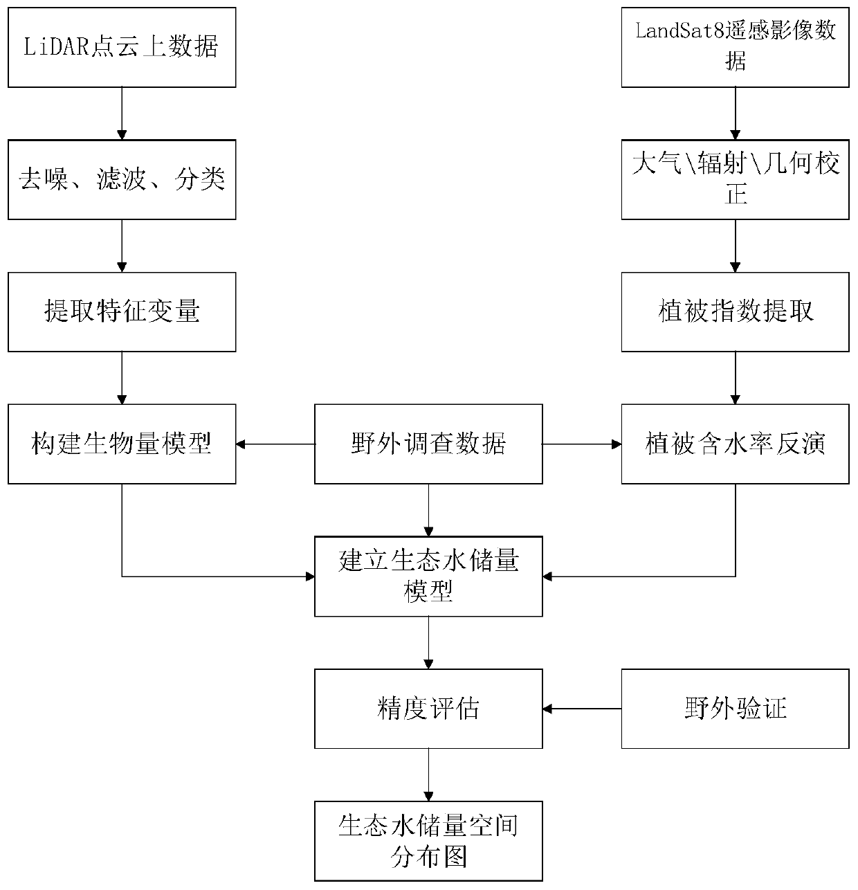
[0027] The present invention provides a method for estimating ecological water reserves of airborne LiDAR and multi-spectral remote sensing technology, comprising the following steps:

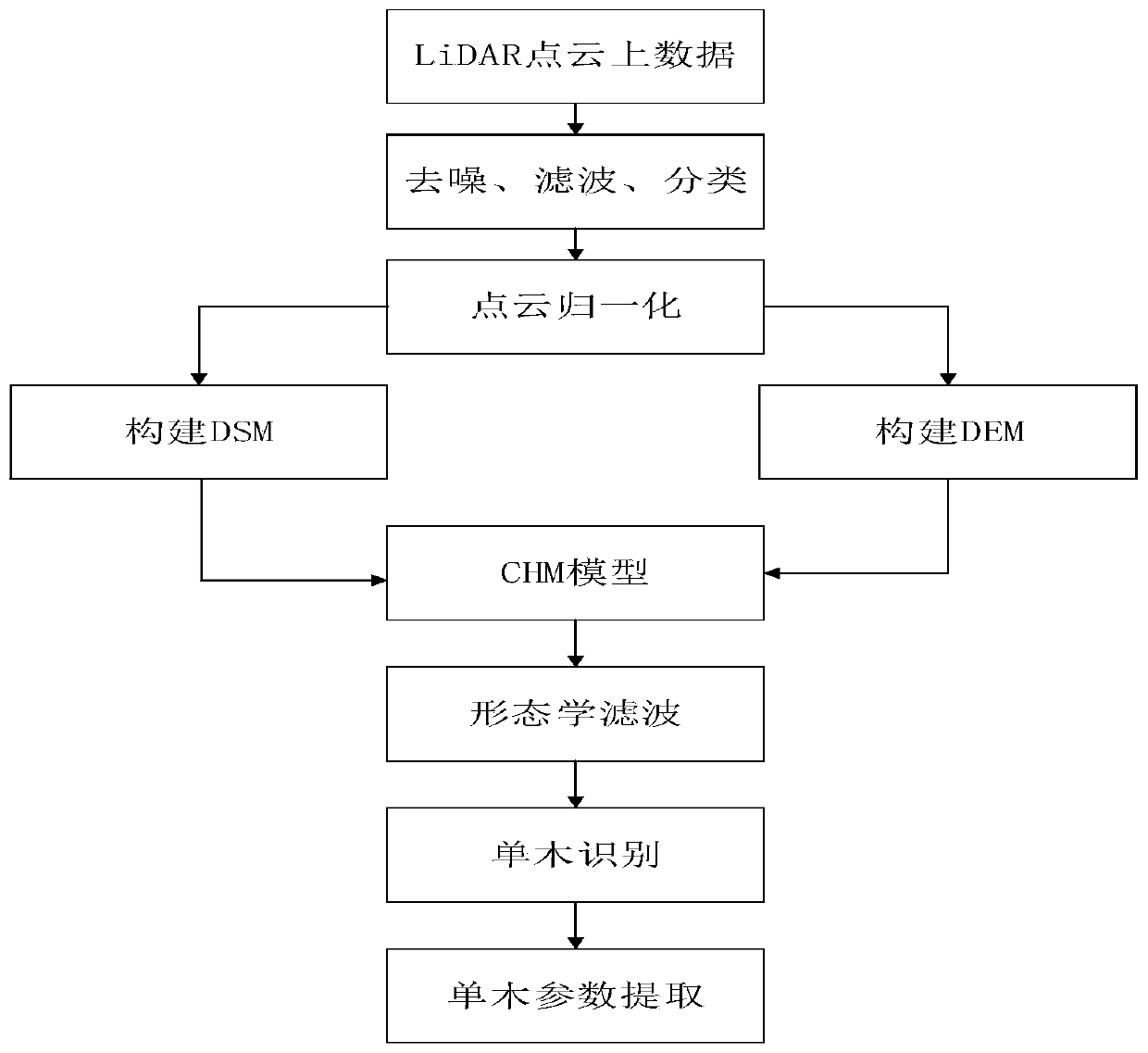
[0028] Step S10: LiDAR point cloud preprocessing and single tree segmentation steps

[0029] LiDAR point cloud preprocessing includes point cloud denoising and classification. Denoising can improve the accuracy of point cloud calculation. Single tree segmentation mainly extrac...


PUM


Abstract

The invention relates to an ecological water reserve estimation method based on an airborne LiDAR and multispectral remote sensing technology. The method comprises the following steps: step S10, performing LiDAR point cloud preprocessing and individual tree segmentation; S20, constructing a LiDAR point cloud biomass estimation model (LiDAR-AGB) based on the LiDAR point cloud characteristic variables and the sample plot actual measurement biomass; S30, LandSat8-OLI image data preprocessing is carried out, vegetation related indexes are extracted, and the water content is inversed; and S40, jointly constructing a vegetation canopy water content estimation model by utilizing the vegetation biomass estimated by the LiDAR point cloud and the vegetation water content inverted by the LandSat8-OLIoptical image, and inverting the vegetation canopy water content (EMC). Therefore, based on the LiDAR point cloud biomass model and the vegetation water content model, the ecological water content ofdifferent vegetations can be indirectly calculated, and the problem that the rainfall conversion link is difficult to quantify is solved; the distribution and water storage characteristics of the western ecological water layer can be found out, and the water resource research and ecological environment research theories can be enriched; potential social and economic values and scientific application prospects are realized.

Description

technical field [0001] The invention relates to the technical field of ecological water calculation research, in particular to a method for estimating ecological water storage by airborne LiDAR and multi-spectral remote sensing technology. Background technique [0002] Ecological water (layer) refers to the total amount of water that can be intercepted (detained) or conserved by surface vegetation (including stem layer of vegetation leaf surface, root soil layer and humus layer, etc.). Its form of existence and movement is different from surface water and groundwater. Its water can be used for evaporation, adjustment and replenishment of surface water and groundwater. It is a special transition zone or transition zone of the water cycle and plays an important role in the entire hydrological cycle. Vegetation moisture content is an important indicator factor to characterize the growth state of vegetation, and an important parameter index for agriculture, forestry, ecology and...

Claims


Application Information

Patent Timeline
IPC IPC(8): G06T7/155
CPCG06T7/155G06T2207/10036
Inventor 杨武年佘金星杨鑫周湘山李红巫明焱雷俊杰谢兵
Owner CHENGDU UNIVERSITY OF TECHNOLOGY
Why Eureka
Try Eureka