Emergency navigation system and method in satellite receiving failure state of vehicle-mounted navigation system

A vehicle navigation device and failure state technology, which is applied in the field of vehicle navigation, can solve problems such as inconvenient driving, vehicle navigation device failure to receive satellites, and inability to obtain positioning data in time, so as to avoid the effect of taking the wrong route

Inactive Publication Date: 2019-11-05
YUANFENG TECH CO LTD
View PDF5 Cites 1 Cited by
  • Summary
  • Abstract
  • Description
  • Claims
  • Application Information

AI Technical Summary

Problems solved by technology

Although the current GPS signal has covered most areas, in real road conditions, there are inevitably some signal blind spots, such as some tunnels, viaducts, underground parking lots or a certain section of mountain road with poor signal coverage. When th

Method used


Image

  • Emergency navigation system and method in satellite receiving failure state of vehicle-mounted navigation system
  • Emergency navigation system and method in satellite receiving failure state of vehicle-mounted navigation system

Examples


Embodiment Construction

[0027] In order to describe the technical content, structural features, realization principle, purpose and effect of the present invention in detail, the following will be described in detail in conjunction with the embodiments and accompanying drawings.

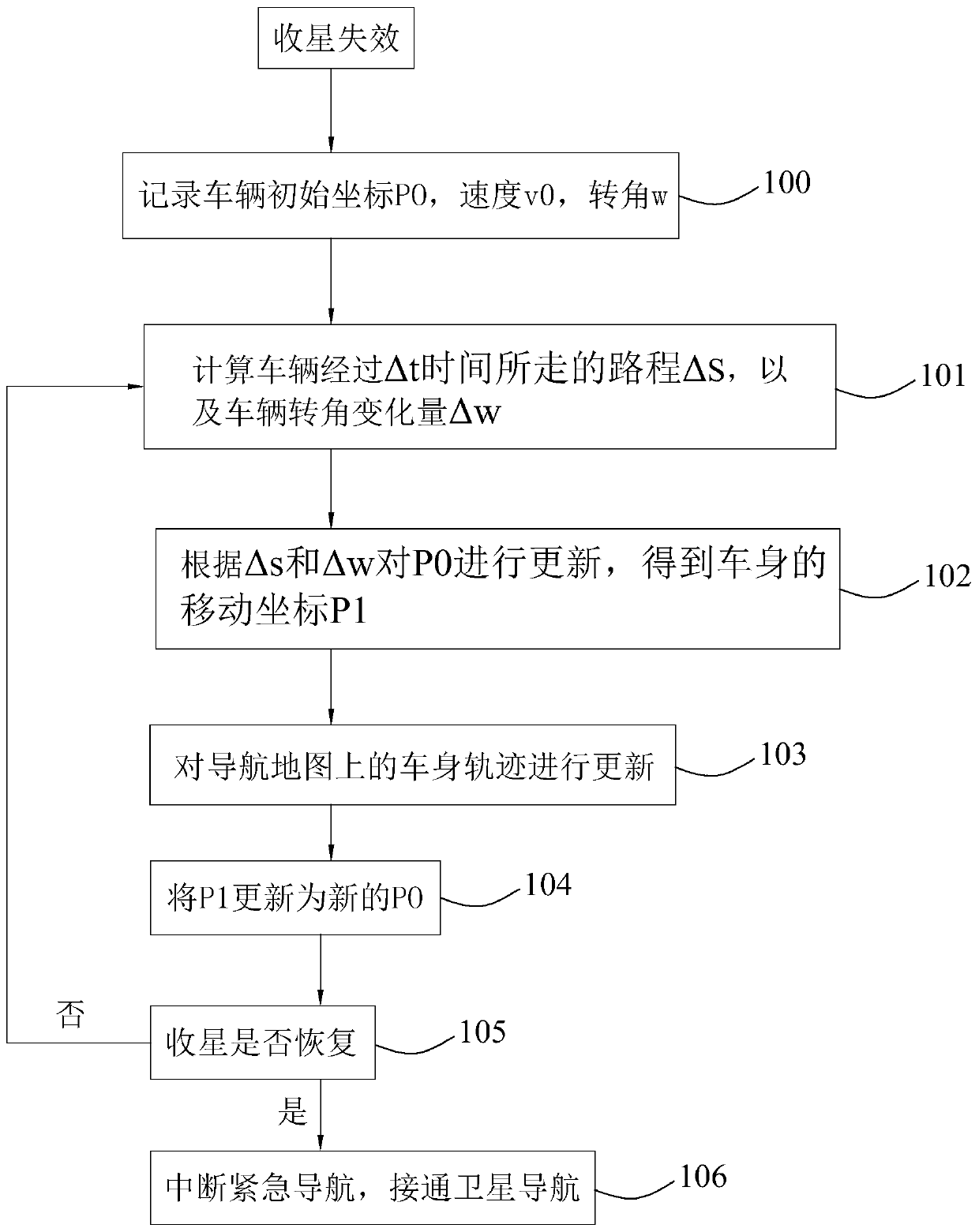
[0028] The invention discloses an emergency navigation method under the condition that a vehicle navigation device fails to receive satellites, which comprises the following steps:

[0029] 1) When the satellite reception fails, record the last positioning data from the navigation satellite before the satellite reception failure and the vehicle body status data at this time. The last positioning data includes the initial coordinate P0 of the vehicle body, and the vehicle body status data includes the vehicle body speed v0 and / or Mileage and body angle w;

[0030] 2) After a very short time Δt, calculate the distance change Δs of the body and the change Δw of the rotation angle of the body;

[0031] 3) The initial coordinate...


PUM


Abstract

The invention discloses an emergency navigation system and method in a satellite receiving failure state of a vehicle-mounted navigation system. The emergency navigation system comprises the followingsteps that (1), the initial coordinate P0, the speed v0 and the angle w of a vehicle are recorded; (2), after a moment delta t, the travelled distance changed quantity delta s of a vehicle body and the angle changed quantity delta w of the vehicle body are calculated; (3), according to the delta s and the delta w, the P0 is updated to obtain the moving coordinate P1 of the vehicle body; (4), according to the moving coordinate P1, the track, on a navigation map, of the vehicle body is updated, so that a vehicle is guided; (5), the newly generated moving coordinate P1 replaces the initial coordinate P0; (6), whether satellite receiving is recovered or not is detected, and if not, the second to sixth steps are executed circularly. When a GPS signal is cut off, the emergency navigation methodis adopted, continuous driving of the vehicle on an existing navigation path can continue to be guided, a driver can get navigation an experience same as that brought by satellite navigation, so thatthe driver is prevented from going in a wrong direction.

Description

technical field [0001] The invention relates to the technical field of vehicle navigation, in particular to an emergency navigation system and method when a vehicle navigation device fails to receive satellites. Background technique [0002] Car navigation is carried out by using car GPS (Global Positioning System) and electronic map. It can tell the driver the shortest or fastest route to the destination conveniently and accurately, and is a good helper for the driver. Although the current GPS signal has covered most areas, in real road conditions, there are inevitably some signal blind spots, such as some tunnels, viaducts, underground parking lots or a certain section of mountain road with poor signal coverage. When the car enters these signal blind spots, The car navigator may fail to receive satellites for a short time, and cannot obtain positioning data in time, which will make car owners who rely on navigation at a loss what to do, thus causing driving inconvenience. ...

Claims


Application Information

Patent Timeline
IPC IPC(8): G01C21/28G01C21/34G01S19/48
CPCG01C21/28G01C21/3407G01S19/48
Inventor 戎海峰刘锦李抢满余立兵
Owner YUANFENG TECH CO LTD
Why Eureka
Try Eureka