Method based on mobile phone voice, GPS track recording and map navigation

A track recording and voice technology, applied in the field of intelligent navigation, can solve problems such as inability to navigate correctly, and achieve the effect of avoiding the wrong way, realizing convenience and practicability.

Inactive Publication Date: 2021-06-11
任悦
View PDF0 Cites 0 Cited by
  • Summary
  • Abstract
  • Description
  • Claims
  • Application Information

AI Technical Summary

Problems solved by technology

However, if the destination location is unknown, it is impossible to navigate correctly.

Method used


Image

  • Method based on mobile phone voice, GPS track recording and map navigation

Examples


Embodiment Construction

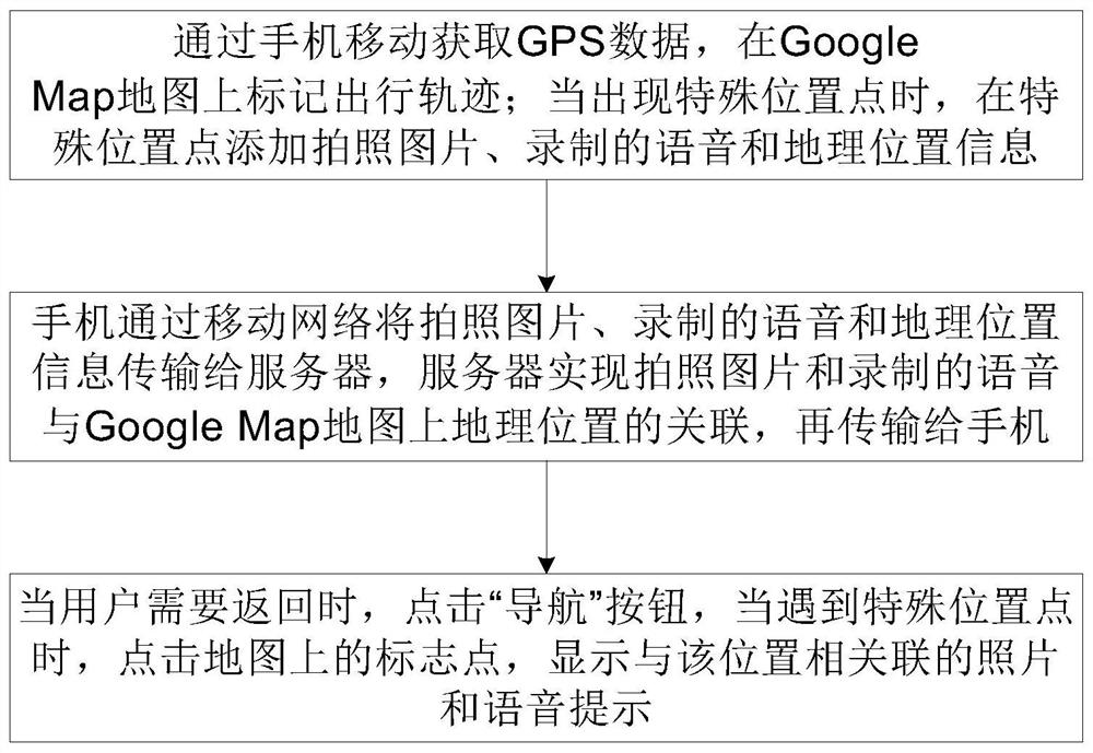
[0021] Such as figure 1 As shown, mobile phones, GPS trajectory records, and map navigation methods, including the following steps:

[0022] Step 1, during the walking process, through the mobile phone to obtain GPS data, and use Google Maps technology, marked the travel trajectory on the Google Map map; in the process of marking the travel trajectory, when a special location point is displayed, add a special location point Take pictures, recorded speech and geographic location information;

[0023] In the specific implementation, the camera function of the phone can be realized by the camera's camera function, and the function of recording the recorded voice can be realized by using the recording function of the phone. No additional equipment, easy to use and low cost.

[0024] Step Second, the phone will transmit the picture, recorded voice and geographic location information to the server through the mobile network, and the server is related to the location of the picture pictu...


PUM


Abstract

The invention discloses a method based on mobile phone voice, GPS track recording and map navigation, which comprises the following steps of 1, acquiring GPS data through mobile phone movement, and marking a travel track on a Google Map map, when the special position point appears, adding the photographed picture, the recorded voice and the geographical position information at the special position point, 2, enabling the mobile phone to transmit the photographed picture, the recorded voice and the geographic position information to a server through a mobile network, and enabling the server to realize the association of the photographed picture and the recorded voice with the geographic position on the Google Map and then transmitting the information to the mobile phone, and 3, when the user needs to return, clicking a 'navigation' button, and when the user encounters a special position point, clicking a mark point on the map, and displaying a picture and a voice prompt associated with the position. The method is simple in steps, convenient to implement and low in cost, recording and navigation can be combined, people can be prevented from walking on wrong roads, and the method is favored by hiking travelers.

Description

Technical field [0001] The present invention belongs to the field of intelligent navigation technology, and specific relates to a method based on mobile phones, GPS trajectory records and map navigation. Background technique [0002] In real life, pedestrians are very important when they go out, especially when they come to unfamiliar cities, how to solve the problem of walking out and can safely walk back. It is very important. Typically, people can find the location through the map, when people open the map, when the route start returns, the difficulty encountering the difficulty must determine where the strange destination is in the map, then on the misunderstanding public transport route Determine a satisfactory travel line with a public transport or walk. [0003] Currently, existing navigation phones, their navigation methods are: We entered the destination or we choose the destination on the map, as a destination start navigation. The case where the destination location is...

Claims


Application Information

Patent Timeline
Patent Type & Authority Applications(China)
IPC IPC(8): G01S19/45G01C21/30
CPCG01C21/30G01S19/45
Inventor 不公告发明人
Owner 任悦
Why Eureka
Try Eureka