Remote sensing image scene classification method based on multi-branch convolutional neural network fusion

A convolutional neural network and remote sensing image technology, applied in the field of remote sensing image scene classification with multi-branch convolutional neural network fusion, can solve problems such as poor classification effect, achieve poor classification effect, improve classification effect, and improve detection effect of ability

Active Publication Date: 2020-12-18
WUHAN UNIV OF SCI & TECH
View PDF3 Cites 1 Cited by
  • Summary
  • Abstract
  • Description
  • Claims
  • Application Information

AI Technical Summary

Problems solved by technology

[0006] In view of this, the present invention provides a remote sensing image scene classification method based on multi-branch convolutional neural network fusion, to solve or at least partially solve the technical problem of poor classification effect existing in the prior art

Method used


Image

  • Remote sensing image scene classification method based on multi-branch convolutional neural network fusion
  • Remote sensing image scene classification method based on multi-branch convolutional neural network fusion
  • Remote sensing image scene classification method based on multi-branch convolutional neural network fusion

Examples


Embodiment 1

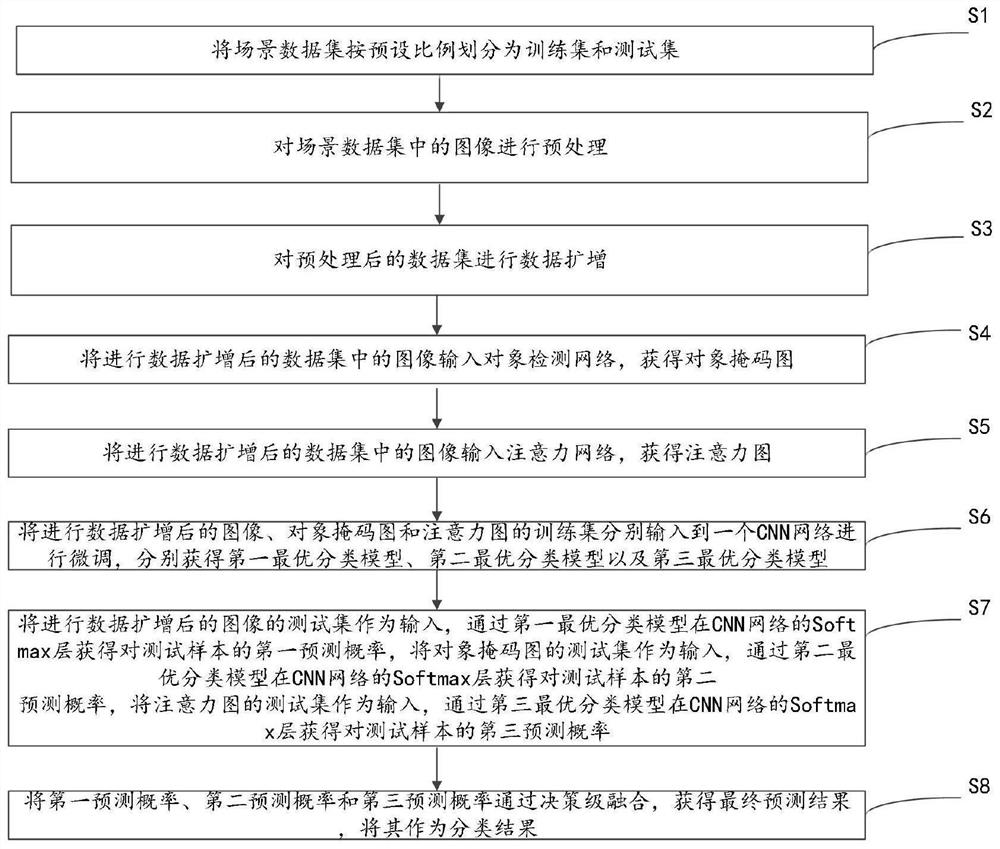
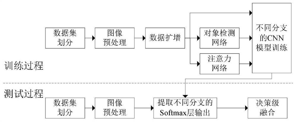
[0090] This embodiment provides a remote sensing image scene classification method fused with a multi-branch convolutional neural network, please refer to figure 1 , the method includes:

[0091] Step S1: Divide the scene data set into a training set and a test set according to a preset ratio.

[0092] Specifically, the scene dataset refers to an open source image scene dataset, which contains multiple categories, and each category includes multiple images. The preset ratio can be set according to needs, such as 1:9, 2:8, 3:7 and so on.

[0093] In the specific example, take the NWPU-RESISC45 scene image dataset as an example. This dataset includes 45 scene classes, each class contains 700 images, and the pixels are 256×256.

[0094] Step S2: Preprocessing the images in the scene dataset.

[0095] Specifically, preprocessing the images in the scene data set is to adjust the format and size of the images in the scene data set to a form that can be processed by the CNN networ...


PUM


Abstract

The invention discloses a remote sensing image scene classification method based on multi-branch convolutional neural network fusion. First, the scene data set is randomly divided into a training set and a test set in proportion; then the data set is preprocessed and data amplified; the processed The final data are obtained through the object detection network and the attention network to obtain the object mask map and the attention map; then the original image, the object mask map and the attention map training set are respectively input into a CNN network for fine-tuning, and the optimal classification model is obtained respectively. , and then the three sets of test sets are used as input to obtain the output of the Softmax layer through the optimal classification model, and finally the outputs of the three sets of Softmax layers are fused at the decision level to obtain the final prediction result. The invention can improve classification accuracy and classification effect.

Description

technical field [0001] The invention relates to the technical field of remote sensing image scene classification, in particular to a remote sensing image scene classification method based on multi-branch convolutional neural network fusion. Background technique [0002] As an important branch of remote sensing image processing technology, remote sensing image scene classification task is of great significance in both military and civilian fields. Scene classification aims to automatically predict a semantic category for each scene image through a learned classifier. However, remote sensing image scenes have rich variations in different colors, viewpoints, poses, spatial resolutions, etc. and various mixed objects, and several image scenes of different categories may be similar to each other in many aspects. To be precise, remote sensing image scene classification still faces challenges due to the problems of intra-class diversity and inter-class similarity. [0003] Tradit...

Claims


Application Information

Patent Timeline
Patent Type & Authority Patents(China)
IPC IPC(8): G06K9/00G06K9/62
CPCG06V20/13G06F18/241G06F18/253
Inventor 边小勇陈春芳张晓龙盛玉霞
Owner WUHAN UNIV OF SCI & TECH
Why Eureka
Try Eureka