Construction method of electromagnetic spectrum map

A construction method and spectrum technology, applied in electrical components, transmission monitoring, transmission systems, etc., to achieve the effect of optimal construction accuracy, low sensor quantity and deployment requirements, and improved accuracy

Active Publication Date: 2019-11-12
NAT UNIV OF DEFENSE TECH
4 Cites 6 Cited by

AI-Extracted Technical Summary

Problems solved by technology

[0007] The purpose of the present invention is to provide a method for constructing an electromagnetic spectrum map based on ordinary kriging in...

Method used

A kind of construction method of electromagnetic spectrum map provided by the present invention, the nearest neighbor propagation clustering is applied on the sensor clustering of random layout, then in the kriging estimation group that several sensor classes form, apply ordinary kriging The interpolation method is use...

Abstract

The invention provides a method for constructing an electromagnetic spectrum map, which comprises the following steps of defining the spatial similarity between any two sensors by using a negative square distance, and updating an attraction degree matrix and an affiliation degree matrix through an iterative process so as to determine the clustering center of the sensors; kriging estimation groupsof different unknown points are established through classes of sensors; calculating an experimental variation function for different Kriging estimation groups, fitting theoretical variation functionsin the different Kriging estimation groups, calculating common Kriging weights of measured values of all sensing points in the Kriging estimation groups, and further calculating common Kriging estimated values; repeating the above steps for many times to estimate the observation value of any position where no sensor is arranged in the area, thereby obtaining the distribution condition of the observation value in the whole area, and achieving the construction of an electromagnetic spectrum map. According to the method, affinity propagation clustering is applied to randomly arranged sensor clustering, so that the electromagnetic spectrum map construction precision and construction efficiency are greatly improved.

Application Domain

Technology Topic

Method of undetermined coefficientsAffinity propagation clustering +7

Image

  • Construction method of electromagnetic spectrum map
  • Construction method of electromagnetic spectrum map
  • Construction method of electromagnetic spectrum map

Examples

  • Experimental program(1)

Example Embodiment

[0055] The embodiments of the present invention will be described in detail below with reference to the accompanying drawings, but the present invention can be implemented in a variety of different ways defined and covered by the claims.
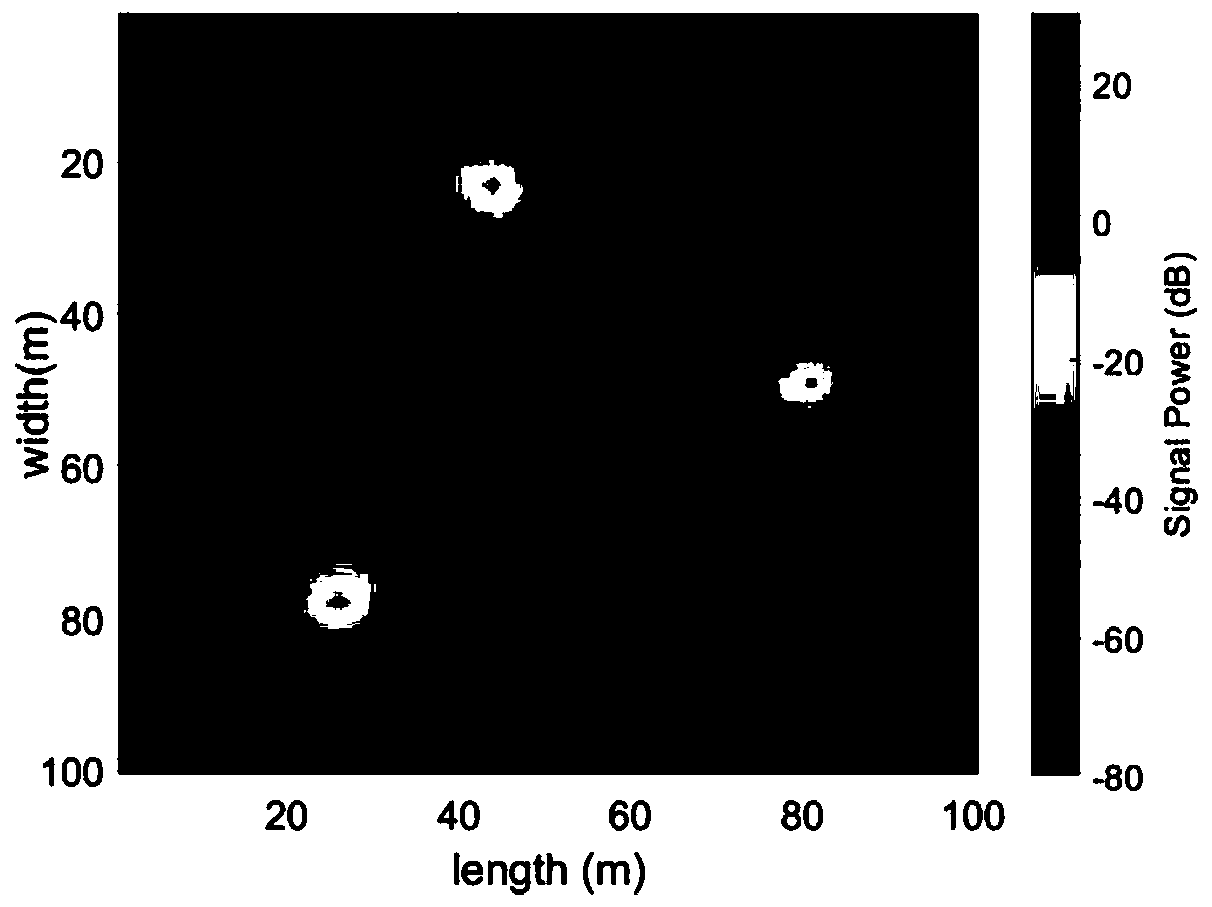
[0056] A method for constructing an electromagnetic spectrum map includes the following steps:
[0057] The first step is to select any two sensors i and j in the space, and use the negative square distance to define the spatial similarity between any two sensors i and j;
[0058] The second step is to update the attraction matrix R and the attribution matrix A through an iterative process to determine the center of the sensor class; the element r(i, j) of the attraction matrix R is used to quantify s j Suitability as s i The degree of the center of, the element a(i,j) of the attribute matrix is ​​used to represent s i Pick s j As its center suitability; where s i And s j Respectively indicate the positions of sensors i and j;
[0059] The third step is to form the Kriging estimation group of different unknown points by the class of the sensor, specifically according to the center of each sensor class to the position of the undistributed sensor s 0 Distance at, select N c Each class is used as the Kriging estimation group of the unknown point;
[0060] The fourth step is to perform experimental variograms for different kriging estimation groups Calculate the experimental variogram according to the expression (1) and the observation value obtained by the sensor, and get the experimental variogram On the discrete value of h, the expression (1) is specifically:
[0061]
[0062] Where z(s i ) Means position s i Observations at z(s i +h) means and position s i The distance between them is the observation value at h, and N(h) represents the corresponding number of sensors at a distance of h;
[0063] The fifth step is to fit the theoretical variogram γ(h) in different Kriging estimation groups, specifically: select the theoretical variogram model, and compare the experimental variogram Perform fitting on the value of discrete h, thereby extending the function domain to any h>0, and then calculating the γ(h) value corresponding to any h>0;
[0064] The sixth step is to calculate the ordinary kriging weight of the measured value of each sensing point in the kriging estimation group, specifically: calculate the position of the undistributed sensor according to the theoretical variation function γ(h) obtained by the fitting and expression (2) s 0 Ordinary kriging weight And the Lagrange multiplier L(s 0 ), the expression (2) is specifically:
[0065]
[0066] Where N is the number of sensors, Indicates the location of the sensor s i And s j The value of the variogram between, L(s 0 ) Is the Lagrangian multiplier to ensure the normalization condition of the Kriging equation;
[0067] The seventh step is to calculate the estimated value of ordinary kriging; specifically, calculate the position s of the undisposed sensor according to the expression (3) 0 The observation value at, the expression (3) is specifically:
[0068]
[0069] among them, Is the estimated value, ω i (s 0 ) Is the weight of the i-th of the N sensors and z(s i ) Is the measured value of the i-th sensor;
[0070] Then according to the expression (4) to obtain the position of the undisposed sensor s 0 The estimated variance of the observed value at, the expression (4) is specifically:
[0071]
[0072] Where σ 2 (s 0 ) Is s 0 Kriging estimate variance at, ω i (s 0 ) Is the weight of the i-th of the N sensors, Indicates the location of the sensor s i And s j The value of the variogram between, L(s 0 ) Is the Lagrange multiplier;
[0073] The eighth step is to repeat the fourth to seventh steps to estimate the observation value at any position where the sensor is not deployed in the area, so as to obtain the distribution of the observation value in the entire area, that is, to realize the electromagnetic spectrum map construction.
[0074] Preferably, in the first step, the negative square distance of any two sensors i and j is calculated according to expression (5) to quantify their similarity; expression (5) is specifically:
[0075] m(s i , S j )=-||s i -s j || 2. (5);
[0076] Where s i And s j Respectively represent the positions of sensors i and j, m(s i ,s j ) Is s i And s j The similarity between.
[0077] Preferably, the initialization of the attractiveness matrix R and the attribution matrix A are both zero matrices,
[0078] The element r(i, j) of the attraction matrix R is calculated according to the expression (6), and the expression (6) is specifically:
[0079]
[0080] The element a(i, j) of the attribute matrix A is calculated according to the expressions (7) and (8), and the expression (7) is specifically:
[0081]
[0082] The expression (8) is specifically:
[0083]
[0084] Among them, r(i,j) is an element in matrix R, a(i,j) is an element in matrix A, m(s i ,s j ) Is s i And s j The similarity between i'and j'are sensors at positions other than i and j;
[0085] The termination condition of the iteration process of the above expressions (6) to (8) is: the boundary of the sensor class no longer changes with the increase of the number of iterations, or the center of the sensor class has been determined after multiple iterations.
[0086] Preferably, in the fifth step, the theoretical variogram model selected by the theoretical variogram γ(h) fitting is the spherical model shown in expression (9), and the specific expression (9) is:
[0087]
[0088] In the above model, C 0 , C and a are the values ​​to be estimated in the model.
[0089] In a specific implementation, consider an area with 3 radiation sources and N randomly deployed sensors. To simulate the electromagnetic environment map in the real scene, the deterministic component based on path attenuation and the random component based on shadow fading are considered at the same time, and the lognormal distribution is used to characterize the random component based on shadow fading. Without loss of generality, set the path loss index to 3, the shadow fading standard deviation to 6, the decorrelation distance to 10m, and the spatial resolution in the area to 1m, so as to obtain a true electromagnetic spectrum map, such as figure 1 Shown.
[0090] In addition, the Inverse Distance Weighted (IDW), Nearest Neighbour (NN), Ordinary Kriging (OK) and Ordinay Kriging based on nearest neighbor propagation clustering are used respectively. Kriging based on Affinity Propagation ClusteringAlgorithm, APCA-OK) for electromagnetic spectrum map construction, such as figure 2 Shown.
[0091] For quantitative comparison, the root mean square error (RMSE) is used to evaluate the accuracy of the electromagnetic spectrum map construction method. The expression of the root mean square error (RMSE) is specifically:
[0092]
[0093] among them, And z(s) are the estimated value and true value of s at the position, and l and w represent the length and width of the scene respectively.
[0094] image 3 It is the relationship curve between the root mean square error of different construction methods and the number of sensors, which characterizes the change trend of the root mean square error of the electromagnetic spectrum map obtained by different construction methods in the case of different numbers of randomly distributed sensors. From image 3 It can be seen that: (1) The performance of all four deterministic interpolation methods participating in the simulation improves with the increase of the number of sensors, but the slope of each line segment gradually decreases, indicating that the higher the sampling rate, the accuracy of electromagnetic spectrum map construction Higher, but as the sampling rate increases, the effect of improving accuracy gradually decreases. (2) Comparing the four different interpolation methods, the root mean square error of APCA-OK is the smallest at any sampling rate, and the performance gain of the sampling rate increase is also the largest, and its performance has strong accuracy. Competitiveness.
[0095] In order to further determine the optimal value of the number of perceptrons in the Kriging estimation group, the root mean square error of the APCA-OK electromagnetic spectrum map constructed under different values ​​is also compared, such as Figure 4 Shown.
[0096] Figure 4 It is the relationship curve between APCA-OK root mean square error and different kriging estimation group sizes, and describes the influence on the overall root mean square error of APCA-OK when different numbers of sensor classes form the kriging estimation group. From Figure 4 It can be seen that the best value is 3 in the simulated real scene set by the method of the present invention. Before 3, the root mean square error decreases with increasing, because the increase in sampling rate within a certain range helps to improve the accuracy of interpolation; after 3, the root mean square error gradually increases with increasing. It is because the measurement value with weak spatial correlation participates in the interpolation estimation, which causes the estimation error to increase.
[0097] In order to further compare the difference in calculation efficiency between APCA-OK and ordinary kriging, the average value of the number of measured values ​​used by the two methods for different sensor numbers at each sensor position is compared, such as Figure 5 Shown.
[0098] Figure 5 For APCA-OK and ordinary kriging single-point measurement values, the relationship curve between the number and the number of sensors is used to describe the number of sensor measurement values ​​and different total sensors used to estimate the field value at a specific unknown point in two different methods The relationship between the quantities is used to measure the difference in the efficiency of electromagnetic spectrum map construction between the two methods. From Figure 5 It can be seen that the number of measured values ​​used by APCA-OK has always been smaller than that of ordinary kriging, and when the amount of ordinary kriging used increases proportionally with the increase in the number of sensors, the measured value of APCA-OK adopts The amount has been slowly increasing, even if the total number of sensors reaches 140, it still remains below 40. In other words, when the sampling rate is high every month, APCA-OK has more obvious advantages in construction efficiency compared with ordinary kriging.
[0099] The method for constructing an electromagnetic spectrum map provided by the present invention applies nearest neighbor propagation clustering to randomly arranged sensor clusters, and then applies ordinary Kriging interpolation to a Kriging estimation group composed of several sensor classes. It is estimated that the use of the spatial correlation of the monitoring data strengthens the correlation between the sensor measurement value and the position where the sensor is not deployed, and improves the construction accuracy of the electromagnetic spectrum map while greatly improving the construction efficiency.
[0100] The above descriptions are only preferred embodiments of the present invention and are not used to limit the present invention. For those skilled in the art, the present invention may have various modifications and changes. Any modification, equivalent replacement, improvement, etc., made within the spirit and principle of the present invention shall be included in the protection scope of the present invention.

PUM

no PUM

Description & Claims & Application Information

We can also present the details of the Description, Claims and Application information to help users get a comprehensive understanding of the technical details of the patent, such as background art, summary of invention, brief description of drawings, description of embodiments, and other original content. On the other hand, users can also determine the specific scope of protection of the technology through the list of claims; as well as understand the changes in the life cycle of the technology with the presentation of the patent timeline. Login to view more.

Similar technology patents

Classification and recommendation of technical efficacy words

Why Eureka
Try Eureka