Multi-vehicle cooperative location and map building method, device and equipment and storage medium

A technology for vehicle positioning and map construction, applied in directions such as road network navigators, can solve the problems of wheel odometer accuracy being easily affected by wheel slip, reducing the environmental adaptability of vehicle positioning and map construction systems, and low map construction efficiency.

Inactive Publication Date: 2018-12-25
JILIN UNIV
View PDF4 Cites 22 Cited by
  • Summary
  • Abstract
  • Description
  • Claims
  • Application Information

AI Technical Summary

Problems solved by technology

[0003] Existing vehicle positioning and map construction technologies mostly use GPS/INS combined inertial navigation positioning. Since GNSS satellite signals may be blocked, and the accuracy of wheel odometers is easily affected by wheel slippage, vehicles cannot meet the positioning requirements in complex driving environments. Accuracy requirements; the existing 64-line laser radar simultaneous positioning and map construction technology (Simultaneous Localization And Mapping, referred to as SLAM) can perform high-precision positioning and map construction for vehicles, but the cost is too high to achieve ...

Method used


Image

  • Multi-vehicle cooperative location and map building method, device and equipment and storage medium
  • Multi-vehicle cooperative location and map building method, device and equipment and storage medium
  • Multi-vehicle cooperative location and map building method, device and equipment and storage medium

Examples


Embodiment Construction

[0052] The following will clearly and completely describe the technical solutions in the embodiments of the present invention with reference to the accompanying drawings in the embodiments of the present invention. Obviously, the described embodiments are only some, not all, embodiments of the present invention. Based on the embodiments of the present invention, all other embodiments obtained by persons of ordinary skill in the art without making creative efforts belong to the protection scope of the present invention.

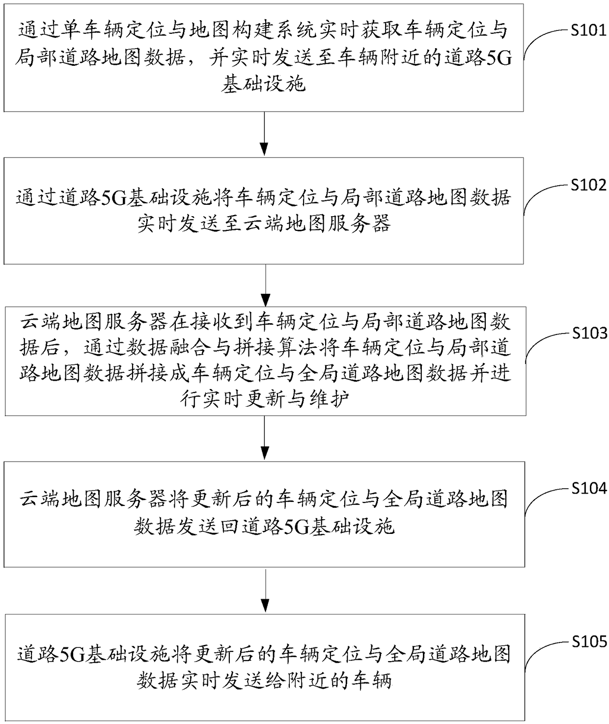
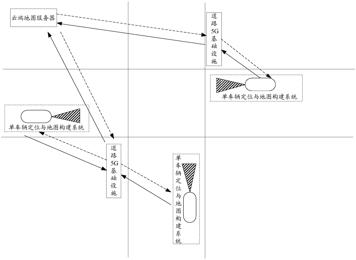
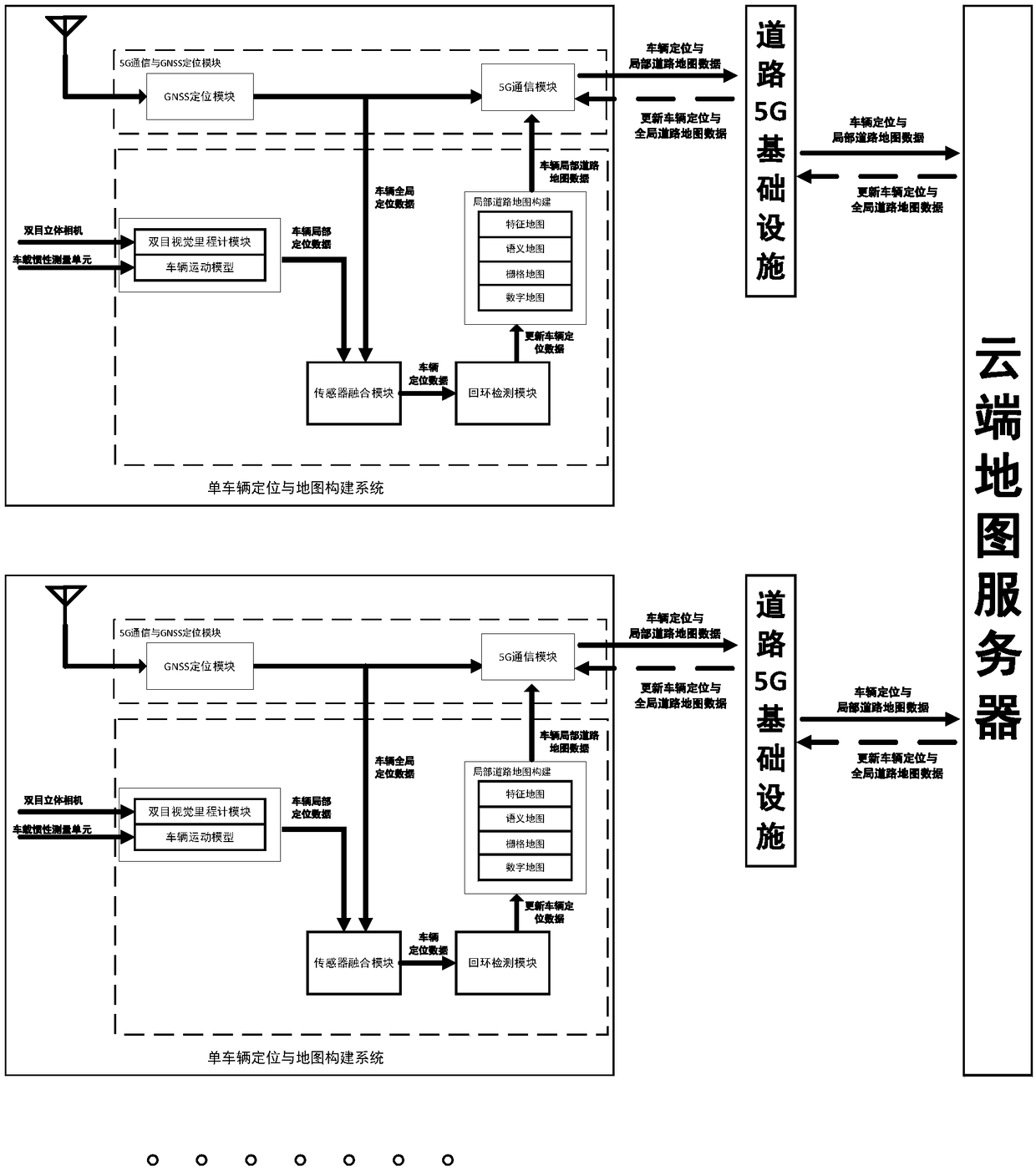
[0053] The present invention provides a multi-vehicle cooperative positioning and map construction method, such as figure 1 and figure 2 shown, including the following steps:

[0054] S101. Obtain vehicle positioning and local road map data in real time through the single vehicle positioning and map construction system, and send them to the road 5G infrastructure near the vehicle in real time;

[0055] S102. Send the vehicle positioning and local road map d...


PUM


Abstract

This application discloses a multi-vehicle cooperative location and map building method, device and equipment and a storage medium. The multi-vehicle cooperative location and map building method comprises the steps that a single-vehicle location and map building system obtains vehicle location and local road map data in real time and sends the data to a road 5G infrastructure near a vehicle; the road 5G infrastructure sends the vehicle location and local road map data to a cloud map server in real time; after the cloud map server splices the local road map data into global road map data through a data fusion and splicing algorithm, the global road map data are updated and maintained in real time and sent back to the road 5G infrastructure; and the road 5G infrastructure sends the updated vehicle location and global road map data to nearby vehicles in real time. When self-localization of a single vehicle is realized, cooperative location and map building with other surrounding vehiclesis carried out, constant updating of a local map is realized, a global map is maintained regularly, and the multi-vehicle cooperative location and map building method is more accurate, more efficientand more robust; and meanwhile, the cost is low, and the efficiency is high.

Description

technical field [0001] The present invention relates to the technical field of multi-vehicle coordination, in particular to a multi-vehicle coordinated positioning and map construction method, device, equipment and storage medium. Background technique [0002] With the advancement of artificial intelligence and vehicle-to-everything (V2X) technology, multi-vehicle collaboration technology is the key technology to realize vehicle intelligence and networking, among which multi-vehicle collaborative positioning and map construction technology are important for realizing automatic driving in V2X scenarios. premise. [0003] Existing vehicle positioning and map construction technologies mostly use GPS / INS combined inertial navigation positioning. Since GNSS satellite signals may be blocked, and the accuracy of wheel odometers is easily affected by wheel slippage, vehicles cannot meet the positioning requirements in complex driving environments. Accuracy requirements; the existin...

Claims


Application Information

Patent Timeline
IPC IPC(8): G01C21/32
CPCG01C21/32
Inventor 马芳武史津竹葛林鹤代凯仲首任蒲永锋
Owner JILIN UNIV
Why Eureka
Try Eureka