Cloud base height estimation method for single-layer cloud facing flight vehicle navigation guidance

A technology for altitude estimation and aircraft, applied in the field of interdisciplinary science, it can solve the problems of large calculation error and failure to discriminate multi-layer clouds, and achieve the effect of improving accuracy

Active Publication Date: 2019-11-15
HUAZHONG UNIV OF SCI & TECH
View PDF5 Cites 7 Cited by
  • Summary
  • Abstract
  • Description
  • Claims
  • Application Information

AI Technical Summary

Problems solved by technology

[0008] For the defects of the prior art, the purpose of the present invention is to solve the existing cloud base height calculation method, before calculating the cloud base height, it is assumed that the cl

Method used


Image

  • Cloud base height estimation method for single-layer cloud facing flight vehicle navigation guidance
  • Cloud base height estimation method for single-layer cloud facing flight vehicle navigation guidance
  • Cloud base height estimation method for single-layer cloud facing flight vehicle navigation guidance

Examples


Embodiment Construction

[0055]In order to make the object, technical solution and advantages of the present invention clearer, the present invention will be further described in detail below in conjunction with the accompanying drawings and embodiments. It should be understood that the specific embodiments described here are only used to explain the present invention, not to limit the present invention. In addition, the technical features involved in the various embodiments of the present invention described below can be combined with each other as long as they do not constitute a conflict with each other.

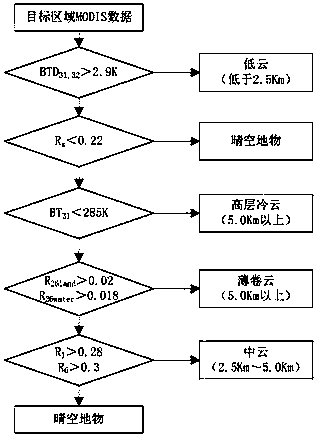
[0056] Because the aircraft's automated, hands-free optical navigation guidance system is in areas covered by clouds, it cannot image-guid the area under the navigation guideline because it cannot obtain imagery of the area. Therefore, before the aircraft departs, it is necessary to obtain the information of the height of the cloud base in the navigation and guidance area to be headed. Aiming at...


PUM


Abstract

The invention discloses a cloud base height estimation method for a single-layer cloud facing flight vehicle navigation guidance. The method comprises that the cloud layer is divided into cloud of different attributes according to data of different wavebands in an Aqua satellite; the number of cloud layers in Cloudsat and the cloud top temperature and optical thickness in Aqua are obtained from asatellite database; the Cloudsat satellite data matches Aqua satellite data in the same latitude and longitude; matched data is divided into a group of training data and a group of test data; a trained model is used to determine whether cloud of different attributes belong to the single-layer cloud; the cloud layer thickness of the single-layer low cloud is calculated by using a physical mathematical model, and a calculation result and data in the Cloudsat serve as parameters in a contrast adjustment model; a model in which a parameter is modified is used to calculate the cloud base height again; and the cloud base height can be obtained by subtracting the cloud layer height from the cloud top height. The cloud base height of the single layer cloud can be calculated, an algorithm is less complex, and the calculation range of the cloud base height is widened.

Description

technical field [0001] The invention relates to the field of interdisciplinary science and technology combining aircraft guidance and atmospheric sounding, and more particularly, relates to a method for estimating the height of monolayer cloud cloud base oriented to aircraft navigation and guidance. Background technique [0002] In the past, it was believed that as long as the automatic optical navigation and guidance system of the aircraft does not need human intervention in areas covered by clouds, it cannot perform image guidance on the area under the navigation guidance line, because it cannot obtain the image of the area. But as long as the clouds covering the detection area are medium clouds or high clouds, it will not have a big impact on the aircraft. Therefore, before the aircraft departs, it is necessary to obtain the information of the height of the cloud base in the navigation and guidance area to be headed. Using various meteorological cloud images and meteorol...

Claims


Application Information

Patent Timeline
IPC IPC(8): G01C5/00
CPCG01C5/00
Inventor 张天序苏益波王中阳梁帅
Owner HUAZHONG UNIV OF SCI & TECH
Why Eureka
Try Eureka