Surface settlement observation method based on tilt photography measurement of drone

A technology of oblique photogrammetry and surface subsidence, which is applied in the field of geographic surveying and mapping, can solve the problems of inability to monitor the overall subsidence of the surface, and the inability to guarantee efficiency and safety, and achieve the effects of low observation cost, fast observation speed, and high efficiency

Inactive Publication Date: 2019-11-15
XIAN UNIV OF SCI & TECH
View PDF5 Cites 11 Cited by
  • Summary
  • Abstract
  • Description
  • Claims
  • Application Information

AI Technical Summary

Problems solved by technology

This method is quite mature, but its efficiency and safety cannot be guaranteed, a

Method used


Image

  • Surface settlement observation method based on tilt photography measurement of drone
  • Surface settlement observation method based on tilt photography measurement of drone
  • Surface settlement observation method based on tilt photography measurement of drone

Examples


Example Embodiment

[0022] The technical solutions in the embodiments of the present invention will be clearly and completely described below in conjunction with the accompanying drawings in the embodiments of the present invention. Obviously, the described embodiments are only a part of the embodiments of the present invention, rather than all the embodiments. Based on the embodiments of the present invention, all other embodiments obtained by those of ordinary skill in the art without creative work shall fall within the protection scope of the present invention.
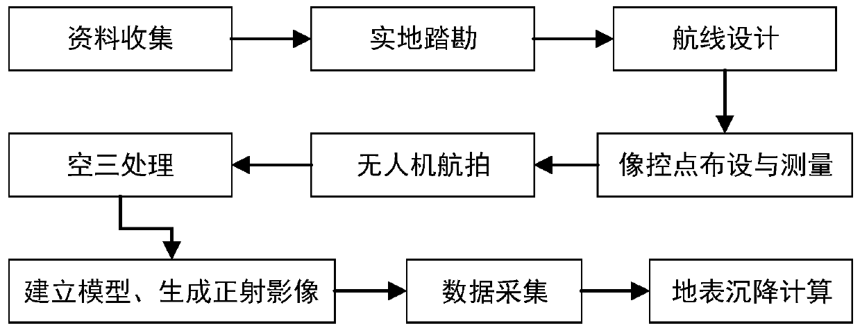
[0023] Reference figure 1 The present invention provides a method for observing surface subsidence based on drone tilt photogrammetry. The present invention uses tilt photogrammetry technology to obtain images of various angles of the collapsed surface, and establishes a subsidence area with spatial information through aerial triangulation and measurement of image control points. Real scene 3D model and orthophoto, use real scene 3D model...


PUM


Abstract

The present invention discloses a surface settlement observation method based on tilt imaging measurement of a drone, to adapt to requirements of surface subsidence monitoring. The method includes thefollowing steps: route planning, layout and measurement of image control points, obtaining of oblique images, establishment of a three-dimensional model of a real view of a measurement area, data collection and making a data difference for subsidence monitoring. In the present invention, an oblique photogrammetry technology is used to obtain images of a collapsed surface in various angles, a real-view three-dimensional model and an orthophoto image of the subsidence zone with spatial information are established by using aerial triangulation measurement and measurement of the image control points, the real-view three-dimensional model is used to collect data of ground points, and a difference is made for the data of the ground points at a same position at different times to obtain a subsidence value for subsidence monitoring. The method is easy to operate, and compared with the traditional subsidence monitoring method, the method has a wide monitoring range and high operation efficiency, and can obtain a more comprehensive monitoring result.

Description

technical field [0001] The invention relates to the technical field of geographic surveying and mapping, in particular to a settlement observation method. Background technique [0002] With the development and maturity of UAV aerial survey and mapping technology, the traditional low-efficiency manual mapping operation method has been gradually replaced. The emergence of UAV photogrammetry technology has greatly improved the measurement accuracy under the premise of ensuring the measurement accuracy. efficiency and safety. Compared with traditional photogrammetry, the accuracy of oblique photogrammetry is greatly improved, and the generated real-world 3D model can intuitively display the actual situation of the measurement area. [0003] The traditional subsidence observation method is to manually lay out the observation line on the main section of the surface mobile basin, and then conduct traditional measurement on the observation line regularly, and process the observatio...

Claims


Application Information

Patent Timeline
IPC IPC(8): G01C5/00G01C11/34
CPCG01C5/00G01C11/34
Inventor 姚顽强杨绪霆郑俊良马柏林
Owner XIAN UNIV OF SCI & TECH
Why Eureka
Try Eureka