Method of Extracting Height Control Points of Building Areas by Satellite Laser Altimetry

An elevation control point and laser technology, which is applied in measuring devices, surveying and navigation, height/horizontal measurement, etc., can solve the problems of large laser footprint, low plane positioning accuracy, and difficulty in directly extracting accurate elevation values ​​of light spots, etc., to achieve The effect of expanding the application range and improving accuracy

Active Publication Date: 2021-06-08
CHINESE ACAD OF SURVEYING & MAPPING
View PDF2 Cites 0 Cited by
  • Summary
  • Abstract
  • Description
  • Claims
  • Application Information

AI Technical Summary

Problems solved by technology

[0006] Due to the large area of ​​the laser footprint, the low precision of plane positioning, and the original echo signal reflects the comprehensive superposition effect of the reflection signals of multiple objects and targets in the spot, it is difficult to directly extract the precise elevation value in the spot, making laser altimetry The application of data in areas with complex structures such as cities and as an auxiliary remote sensing image photogrammetry is greatly restricted. At present, there is no relevant achievement of using the full waveform decomposition method of laser altimetry to extract the elevation control points of building areas.

Method used


Image

  • Method of Extracting Height Control Points of Building Areas by Satellite Laser Altimetry

Examples


Embodiment Construction

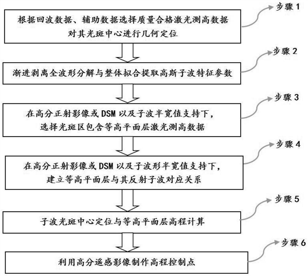
[0043] Such as figure 1 As shown, the present invention is carried out by the following steps:

[0044] Step 1, determine the laser measurement of high data quality, select the quality of the laser measurement data, calculate the corresponding precise distance using the return waveform peak time, and the satellite position and the sensor posture are carried out in the center of the laser spot when beam emission Geometric positioning.

[0045] Where the laser measurement high data quality is determined by the parameters of the laser measurement requirements of the laser measurement requirements based on the gesture quality, cloud volume, reflectivity, and ground target of the satellite measurement, the laser measurement height of the surface target, and the external DSM elevation deviation. The corresponding accurate distance is based on the time of beam round-trip satellite and target, and the initial distance is calculated and corrected by the system error, atmospheric delay, tid...


PUM


Abstract

The invention provides a method for extracting elevation control points of building areas by satellite laser altimetry. Accurately extract Gaussian sub-waveform characteristic parameters and overall fitting; use high-resolution images or digital surface model (DSM) data, and Gaussian sub-wave half-width value parameters to select laser altimetry data containing contour plane layers within the spot range; Establish the corresponding relationship between the contour plane layer and its reflected Gaussian wavelet; use the precise distance of the center position of the sub-waveform characteristic parameters obtained by decomposition to locate the center of the spot, and calculate the absolute elevation of the corresponding contour plane layer; combine with high-resolution images , making remote sensing image elevation control points. The invention uses the full-waveform large-spot laser altimetry data as the remote sensing image elevation control point to expand the field from flat terrain to building areas and other areas containing contour plane layers.

Description

Technical field [0001] The present invention belongs to the field of laser radar, and it is particularly involved in the auxiliary image of the on-load laser radar data to use technology. Specifically, there is a satellite laser measurement building area based on laser-based geometric positioning and full-wave decomposition. Elevation control point method. Background technique [0002] Laser radar and imaging spectroscopy, imaging radar and called three major front-edge technology in the field of land observations, some foreign developed countries start early in the high field of on-line laser radar, and the NASA launched in 2003. Equipped with ICESAT-1 satellite with Earth Science Laser System (Glas), which has a high precision of 0.15m, which has obtained a large number of high-precision global three-dimensional space information, but due to laser failure, the Star has stopped data collection in 2009. jobs [1] . In order to continue to complete the scientific tasks of ICESAT-1,...

Claims


Application Information

Patent Timeline
Patent Type & Authority Patents(China)
IPC IPC(8): G01C5/00G01S7/48G01C11/00
CPCG01C5/00G01C11/00G01S7/4802
Inventor 程春泉谭建伟杨书成黄国满
Owner CHINESE ACAD OF SURVEYING & MAPPING
Why Eureka
Try Eureka