BIM and GIS integration method based on semantic fusion

An integrated method and semantic technology, applied in the field of information processing, can solve problems such as data loss, and achieve the effect of avoiding data errors and missing data

Pending Publication Date: 2019-11-26
史健勇
View PDF6 Cites 14 Cited by
  • Summary
  • Abstract
  • Description
  • Claims
  • Application Information

AI Technical Summary

Problems solved by technology

[0019] In view of the above-mentioned deficiencies in the prior art, the purpose of the present invention is to provide a method for integrating BIM and GIS based on semantic fusion, which integrates the semantics in IFC and CityGML, and avoids the conversion of data formats. The two data formats are semantically expanded to solve the problem of data loss

Method used


Image

  • BIM and GIS integration method based on semantic fusion
  • BIM and GIS integration method based on semantic fusion
  • BIM and GIS integration method based on semantic fusion

Examples


Embodiment Construction

[0069] The following is a detailed description of the embodiments of the present invention: this embodiment is implemented on the premise of the technical solution of the present invention, and provides detailed implementation methods and specific operation processes. It should be noted that those skilled in the art can make several modifications and improvements without departing from the concept of the present invention, and these all belong to the protection scope of the present invention.

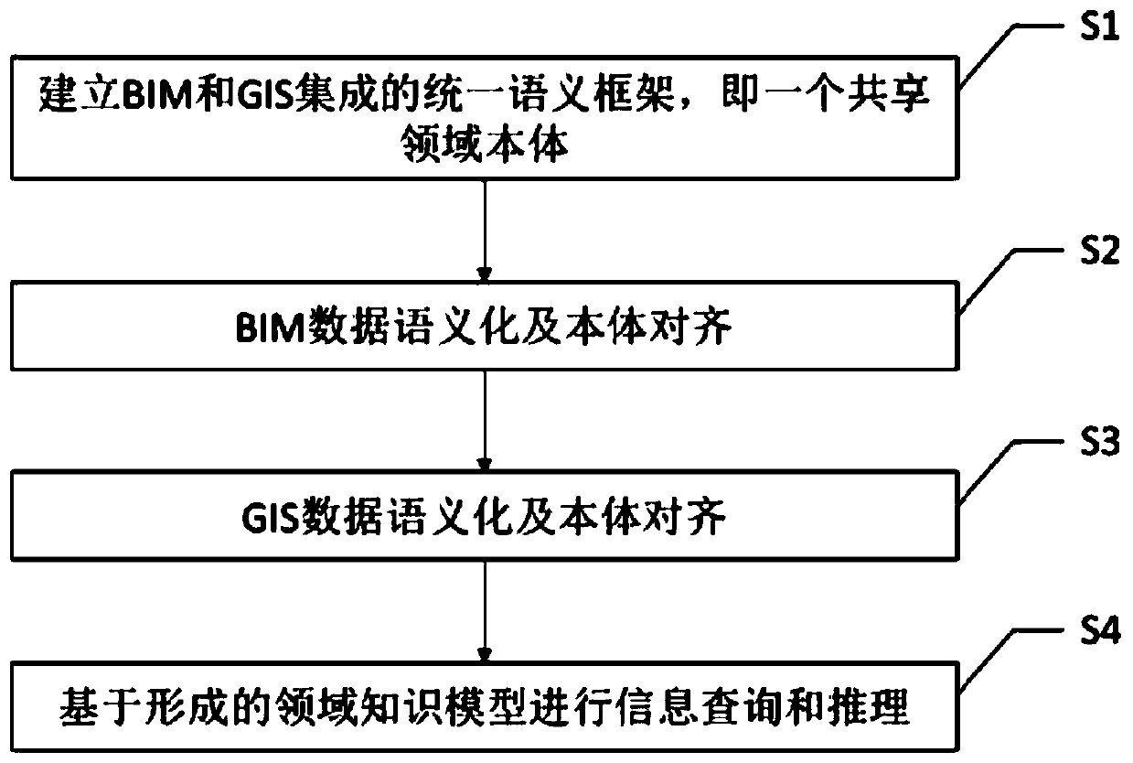
[0070] The embodiment of the present invention provides a BIM and GIS integration method based on semantic fusion, which is a method based on semantic web and ontology technology to realize the fusion of BIM and GIS information from the semantic level, specifically including the following steps:

[0071] S1, establish a unified semantic framework for the integration of BIM and GIS, that is, a shared domain ontology;

[0072] S2, BIM data semantics and ontology alignment, obtain instance...


PUM


Abstract

The invention provides a BIM and GIS integration method based on semantic fusion. The BIM and GIS integration method comprises the steps: S1, building a unified semantic framework of BIM and GIS integration, and forming a shared domain ontology; S2, obtaining instance information from the BIM data model to fill the shared domain ontology; S3, semantizing the GIS data and filling the GIS data intoa shared domain ontology in an ontology alignment mode; and S4, realizing information query and reasoning based on the fused domain knowledge model. The BIM and GIS integration method researches a method for converting IFC and CityGML into an RDF graph model, so as to enable the heterogeneous data to be expressed by a semantic-based knowledge model, thus solving the fusion problem of heterogeneousinformation of BIM and GIS, classifies, maps and hierarchically organizes classes and relations in the field to form concept integration under a unified framework, well processes and displays representation of knowledge, and infers implicit knowledge through establishment of logic rules.

Description

technical field [0001] The invention relates to the technical field of information processing, in particular to a method for integrating BIM and GIS based on semantic fusion. Background technique [0002] The integration of BIM and GIS can realize the integration of different spatial scale information from indoor to outdoor, and bring the advantages of both into the analysis, decision-making and management of building and urban information. The difficulty of integrating BIM and GIS is to solve the problem of data interoperability, which is manifested in different modeling languages, different spatial scales and granularities, and different geometric and semantic expressions. The current integration of BIM and GIS is mainly carried out around the two common data standards of IFC and CityGML, including data level and application level. [0003] Data-level integration methods include: 1) conversion of existing data formats; 2) establishment of new standards. The existing data...

Claims


Application Information

Patent Timeline
Patent Type & Authority Applications(China)
IPC IPC(8): G06F16/28G06F16/29G06F17/50
CPCG06F16/288G06F16/29
Inventor 史健勇
Owner 史健勇
Why Eureka
Try Eureka