Remote sensing image map tile real-time fusion and online updating method

A remote sensing image and map tile technology, which is applied in database update, image data processing, geographic information database, etc., can solve problems such as heavy workload, inability to use remote sensing image tile data, and inability to update image tiles in real time , to achieve the effect of reducing dependence, improving efficiency and flexibility, and avoiding data storage overhead

Pending Publication Date: 2019-11-26
武汉数趣信息科技有限公司
View PDF6 Cites 9 Cited by
  • Summary
  • Abstract
  • Description
  • Claims
  • Application Information

AI Technical Summary

Problems solved by technology

The traditional remote sensing image tile service construction model has a heavy workload, and cannot use th

Method used


Image

  • Remote sensing image map tile real-time fusion and online updating method
  • Remote sensing image map tile real-time fusion and online updating method
  • Remote sensing image map tile real-time fusion and online updating method

Examples


Example Embodiment

[0062] Specific embodiments of the present invention are described in detail below. It should be noted that the embodiments described here are only used for illustration, and are not used to limit the present invention:

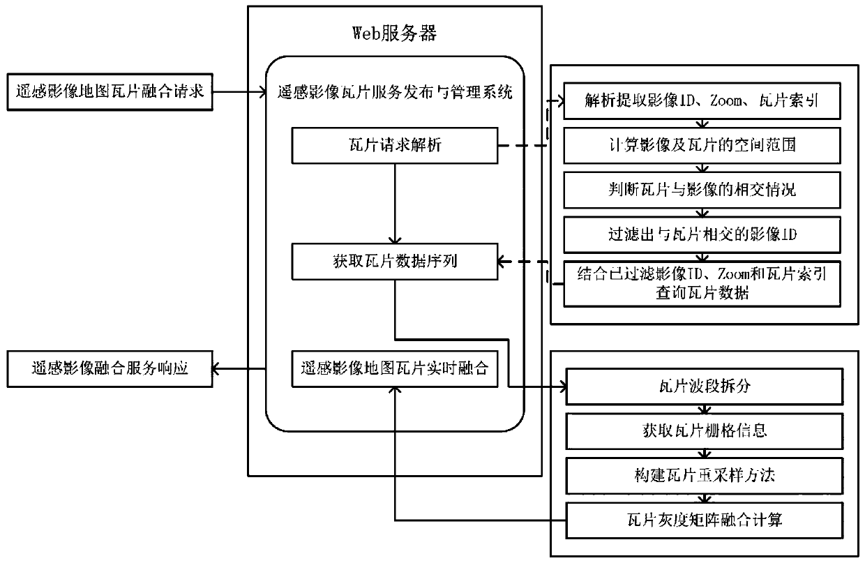
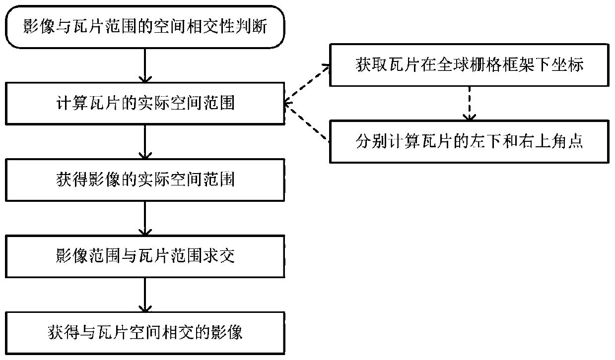
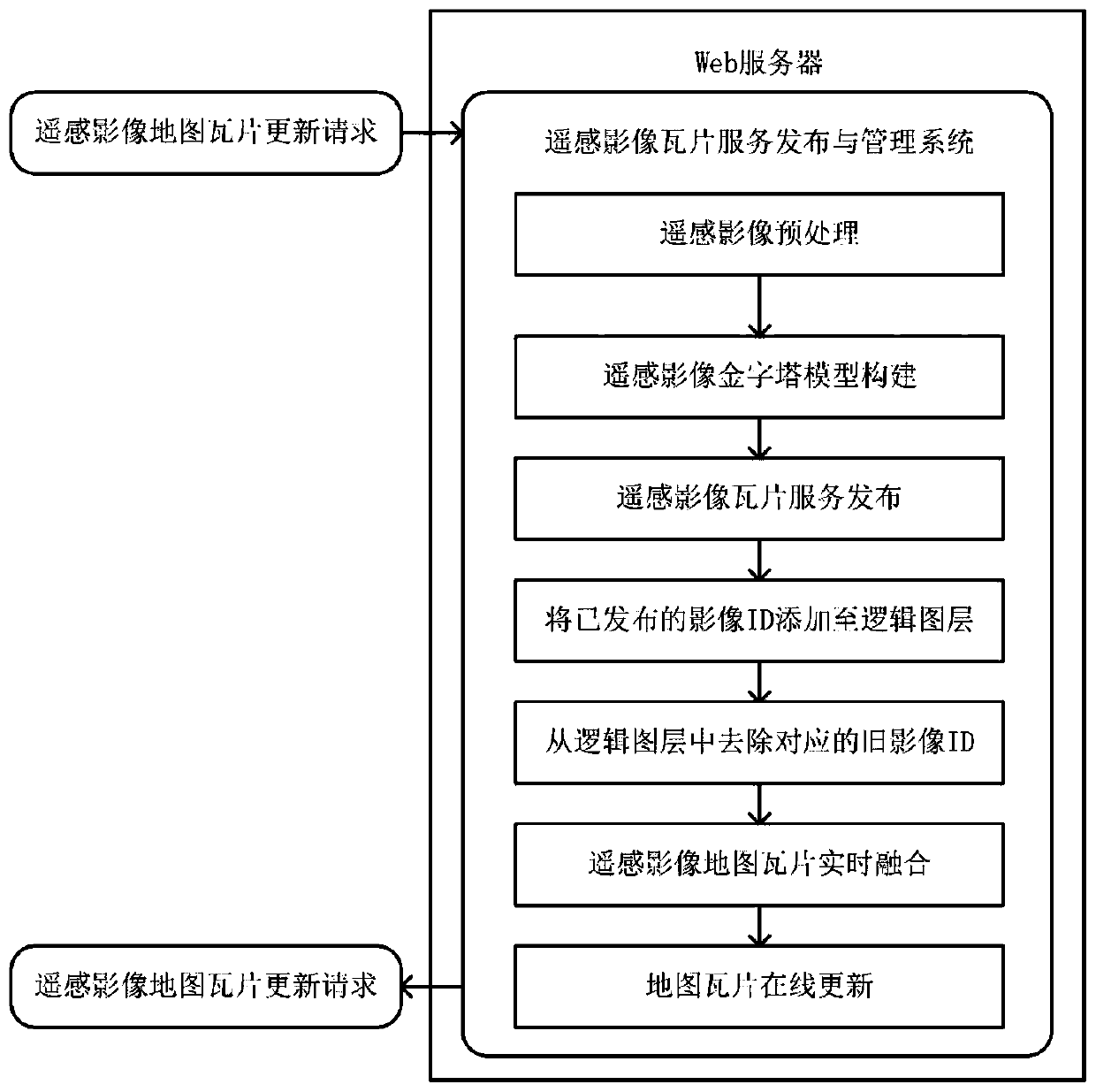
[0063] The invention is based on the remote sensing image service publishing and management system, and realizes the real-time fusion and online update of remote sensing image tiles under non-invasive conditions. The real-time fusion structure of remote sensing image map tiles is figure 1 Shown. The web server in the figure is a Spark cluster based on a distributed environment, and the remote sensing image tile service publishing and management system is composed of a distributed remote sensing image processing framework. User requests use RESTful services to interact with the image tile service release management system.

[0064] According to the specific design of the embodiment of the present invention, the steps of real-time fusion implementation of remote s...


PUM


Abstract

The invention relates to a remote sensing image map tile real-time fusion and online updating method. The remote sensing image map tile real-time fusion and online updating method comprises the steps:remote sensing image tile real-time fusion: remote sensing image tile real-time fusion is established on the basis of an existing image tile service, and merging browsing of image tiles is achieved by conducting fusion on overlapping areas; and remote sensing image tile online updating: remote sensing image tile updating refers to a process of replacing original image tile data with new remote sensing image tile data. According to the remote sensing image map tile real-time fusion and online updating method, on the premise that the original image map tile service is not modified, random splicing and fusion of the image tiles can be realized, and the utilization rate of resources is improved. Meanwhile, online updating of the remote sensing image can be realized under a non-invasive condition, so that new and old image data can be updated and replaced under the condition that user operation is not influenced, and high availability and robustness of the remote sensing image map tile service system are enhanced.

Description

Technical field: [0001] The invention relates to a data processing method in the field of spatial geographic information science, in particular to an image map tile processing method in remote sensing image data analysis. Specifically, it involves realizing real-time fusion or online update of image map tiles without affecting the published remote sensing image map tile services. Through the real-time fusion of local image tile services scattered in the target area, the integration of the target area tile services is realized; through the online update of the local image tile services, the gradual update of the target area tile services is realized. Background technique: [0002] Remote sensing images are an important class of data resources. In order to realize online browsing of remote sensing images, it is necessary to perform pyramid modeling on the obtained remote sensing images to construct image map tile services. Due to the images taken by remote sensing satellites,...

Claims


Application Information

Patent Timeline
IPC IPC(8): G06F16/29G06F16/23G06F16/28G06F16/955G06T17/05
CPCG06F16/29G06F16/23G06F16/28G06F16/9566G06T17/05Y02D10/00
Inventor 郑杰
Owner 武汉数趣信息科技有限公司
Why Eureka
Try Eureka