Boundary exploration autonomous mapping method based on curve fitting and target point neighborhood planning

A curve fitting, target point technique

Active Publication Date: 2019-12-03
GUANGDONG UNIV OF TECH
View PDF3 Cites 23 Cited by
  • Summary
  • Abstract
  • Description
  • Claims
  • Application Information

AI Technical Summary

Problems solved by technology

However, there are still several problems: 1. The conditions for selecting candidate points for exploration are lacking
The selection of exploration candidate points is based on the boundary algorithm selection, without considering the accessibility and security of candidate points
2. It takes a long time to explore and build a map. When the robot cannot navigate to the exploration target point, there is no effective real-time solution, which often prolongs the map building time.

Method used


Image

  • Boundary exploration autonomous mapping method based on curve fitting and target point neighborhood planning
  • Boundary exploration autonomous mapping method based on curve fitting and target point neighborhood planning
  • Boundary exploration autonomous mapping method based on curve fitting and target point neighborhood planning

Examples


Embodiment 1

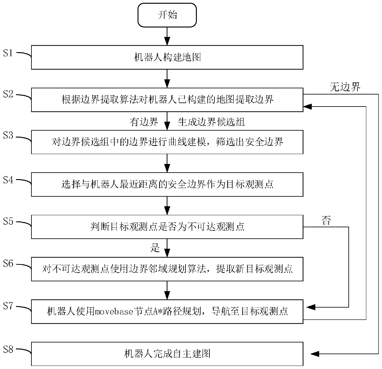
[0047] Such as figure 1 As shown in , the boundary exploration autonomous mapping method based on curve fitting and target point neighborhood planning includes the following steps:

[0048] S1: The robot constructs the map;

[0049] S2: Extract the boundary from the map constructed by the robot according to the boundary extraction algorithm, and judge whether there is a boundary, and if so, generate a boundary candidate group, otherwise perform step S8;

[0050] S3: Carry out curve modeling on the boundaries in the boundary candidate group, and screen out the safety boundaries;

[0051] S4: Select the safety boundary closest to the robot as the target observation point;

[0052] S5: Determine whether the target observation point is an unreachable observation point, if so, execute step S6, otherwise execute step S7;

[0053] S6: Use the boundary neighborhood planning algorithm for unreachable observation points to extract new target observation points;

[0054] S7: The robo...

Embodiment 2

[0058] More specifically, the step S1 is as follows: In the ROS system, the odometer node is used to obtain the initial pose of the robot, and the robot uses the Gmapping algorithm to construct a map throughout the process.

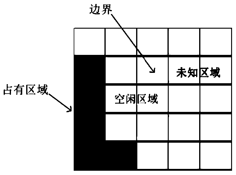
[0059] More specifically, the map model adopted by the Gmapping algorithm is a grid map; the grid map directly obtains the occupancy state of the environment through the distance information of the sensor, and provides environmental feature data; each grid in the grid map has three states , including idle state, occupied state and unknown state; where:

[0060] The idle state indicates that there is no obstacle at the grid;

[0061] The occupancy state indicates that there are obstacles at the grid, which need to be avoided during path planning of the robot;

[0062] The unknown state indicates that the grid is not perceived by the robot and belongs to an unknown environment.

[0063] In the specific implementation process, when the robot conducts auton...

Embodiment 3

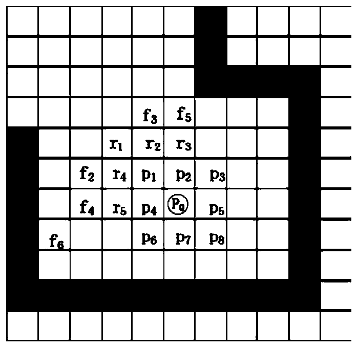
[0072] In the specific implementation process, there are many short, slender, and narrow boundaries in the candidate boundary group. These boundaries cannot accommodate the robot, causing the robot to enter the narrow area and collide, or make the robot execute path planning for a long time, but there is no path to reach. Increased autonomous map building time. Therefore, in view of the above defects, this method proposes to remove unsafe boundaries and retain safe and effective boundaries by means of curve modeling for the boundaries in the candidate boundary group, specifically:

[0073] S31: Establish the local boundary coordinate system of the boundary candidate group: the boundary in the candidate boundary group is a series of two-dimensional coordinate points based on the robot map coordinate system, which does not contain the direction information of the boundary, so the curve modeling of the boundary needs to be established first The local coordinate system of the boun...


PUM


Abstract

The invention provides a boundary exploration autonomous mapping method based on curve fitting and target point neighborhood planning. For boundaries of an established map, target observation regionsare screened in a curve fitting mode. For a robot unreachable target observation region, a new target observation point is established through adoption of a neighborhood planning method, a robot is autonomously navigated to a next observation region through utilization of synchronous positioning and mapping technologies, and autonomous exploration for an unknown environment is finished. Accordingto the boundary exploration autonomous mapping method based on curve fitting and target point neighborhood planning provided by the invention, autonomous exploration mapping for an unknown indoor complex scene is finished with relatively few exploration times, relatively high exploration efficiency and relatively less exploration time, autonomy and intelligence of finishing mapping by the robot are improved, search mapping can be finished without manual intervention, and manpower and material costs are reduced.

Description

technical field [0001] The present invention relates to the technical field of autonomous navigation robot exploration and autonomous mapping, and more specifically, relates to a boundary exploration and autonomous mapping method based on curve fitting and target point neighborhood planning. Background technique [0002] With the rapid development of robot technology and the transformation of social needs, autonomous mobile robots have attracted more and more attention from engineering and academia. In order for an autonomous mobile robot to autonomously help people complete daily tasks in an unstructured and uncertain environment, the key technology is to establish a map of the external environment inside the robot for subsequent navigation when the robot is in an unknown environment. . However, the traditional way of robot mapping is to control the movement of the robot manually or using a keyboard or joystick, which will waste time, manpower and material resources when f...

Claims


Application Information

Patent Timeline
Patent Type & Authority Applications(China)
IPC IPC(8): G05D1/02
CPCG05D1/02
Inventor 刘瑞雪曾碧张伯泉
Owner GUANGDONG UNIV OF TECH
Why Eureka
Try Eureka