Method for providing assistance data to mobile station of a satellite positioning system

a satellite positioning system and mobile station technology, applied in satellite radio beaconing, measurement devices, instruments, etc., can solve the problems of emergency call position fixing, low data rate of signalling layers, and insufficient accuracy of almanac data to allow a precise position fix that meets system specifications, so as to reduce the duration of position fixing, increase the accuracy of calculated positions, and save communication channel bandwidth

Active Publication Date: 2009-12-10
THE EURO UNION REPRESENTED BY THE EURO CO
View PDF5 Cites 35 Cited by
  • Summary
  • Abstract
  • Description
  • Claims
  • Application Information

AI Technical Summary

Benefits of technology

[0013]As will be appreciated, the disclosed method reduces the impact on the capacity of a communication channel between the server station and the mobile station while taking into account whether the transmission of the broadcast ephemeris data or the long-term ephemeris data is appropriate. In fact, updates of the ephemeris data stored at the mobile stations become less frequent. This results in a net reduction of bandwidth, since the overall size of long-term ephemeris data does not exceed the size of conventional ephemeris data. On the other hand, this increases the autonomy of the receiver, i.e. the period during which the receiver does not need additional assistance data. Preferably, the period of validity of the long-term ephemeris data is increased by at least a factor of 1.5, more preferably, by at least a factor of 2, and still more preferably, by at least a factor of 4, with respect to conventional ephemeris data. Preferably, the format of the long-term ephemeris data is the same as the format of the broadcast ephemeris data, so as to remain compatible with existing standards.
[0015]If the server station is equipped with a GNSS receiver, it can acquire and store the ephemeris data broadcast by the satellites as long as these are visible from the location of the receiver. If a satellite has disappeared at the horizon, the server station may compute the orbit of the satellite based on the stored ephemeris data. The skilled person will notice that this considerably reduces the problem of “roaming”. Assume, for instance, the server station and its reference receiver are located in Europe, whereas the mobile station requests assistance data for Australia. In this exemplary and non-limiting case of figure, the reference receiver does not provide the server station with current ephemeris data of the concerned satellites, i.e. with those satellites that can be used at the same time for navigation in Australia. The server station may then compute long-term orbit predictions for these satellites based on the most recent ephemeris data in memory. It should be noted that, in this case, the period of time between the most recent ephemeris data and the time of the request is included in the period over which the orbit is predicted. Subsequently, these predictions are used for deriving current long-term ephemeris data. Unlike in known systems, the server station does not need to be connected to a reference network of receivers distributed around the globe. If placed in a suitable geographical location, a single reference receiver may be sufficient. It is not necessary that the reference receiver is located in the same geographical area as the server station.
[0016]Optionally, the assistance data transmitted to the mobile station may comprise ionospheric refraction data and / or synchronisation data in addition to the ephemeris data. The kind of data to be transmitted can be specified by the mobile station in the request for assistance data. Ionospheric refraction data or synchronisation data may further reduce the duration of the position fixing or increasing the accuracy of the calculated position. Most preferably, the server station receives with the request for assistance data an initial guess of the location of the mobile station e.g. the information on the cell of the communication network, in which the mobile station is located. The server station may then optimise the assistance data according to the initial guess Location-specific optimisation may be achieved in view of saving bandwidth of the communication channel between the mobile station and the server station. For instance, the ephemeris data sent to the mobile station can be reduced to ephemeris data concerning only those satellites that are currently visible from the cell of the communication network. Ionospheric refraction data transferred to the mobile station may be reduced to location-specific ionospheric refraction data.

Problems solved by technology

Almanac data are not accurate enough to allow a precise position fix that meets the system specifications, or the end user's expectations (usually up to a few tens of metres).
Nevertheless, the user can access to this layer only if he has subscribed, which raises the issue of position-fixing related to emergency calls.
The main drawback is that the signalling layers have a low data rate, which leads to problems if many mobile stations request for assistance data.
A problem that is not addressed by the above document is concerned with “roaming”, i.e. when the mobile station asks for assistance data when located in a geographical area that is not covered by its home operator.
The operator currently has the possibility to build the network on his own, which is very costly, or conclude a service contract with an owner of such a reference network, which makes him dependent from another party.

Method used


Image

  • Method for providing assistance data to mobile station of a satellite positioning system
  • Method for providing assistance data to mobile station of a satellite positioning system
  • Method for providing assistance data to mobile station of a satellite positioning system

Examples


Embodiment Construction

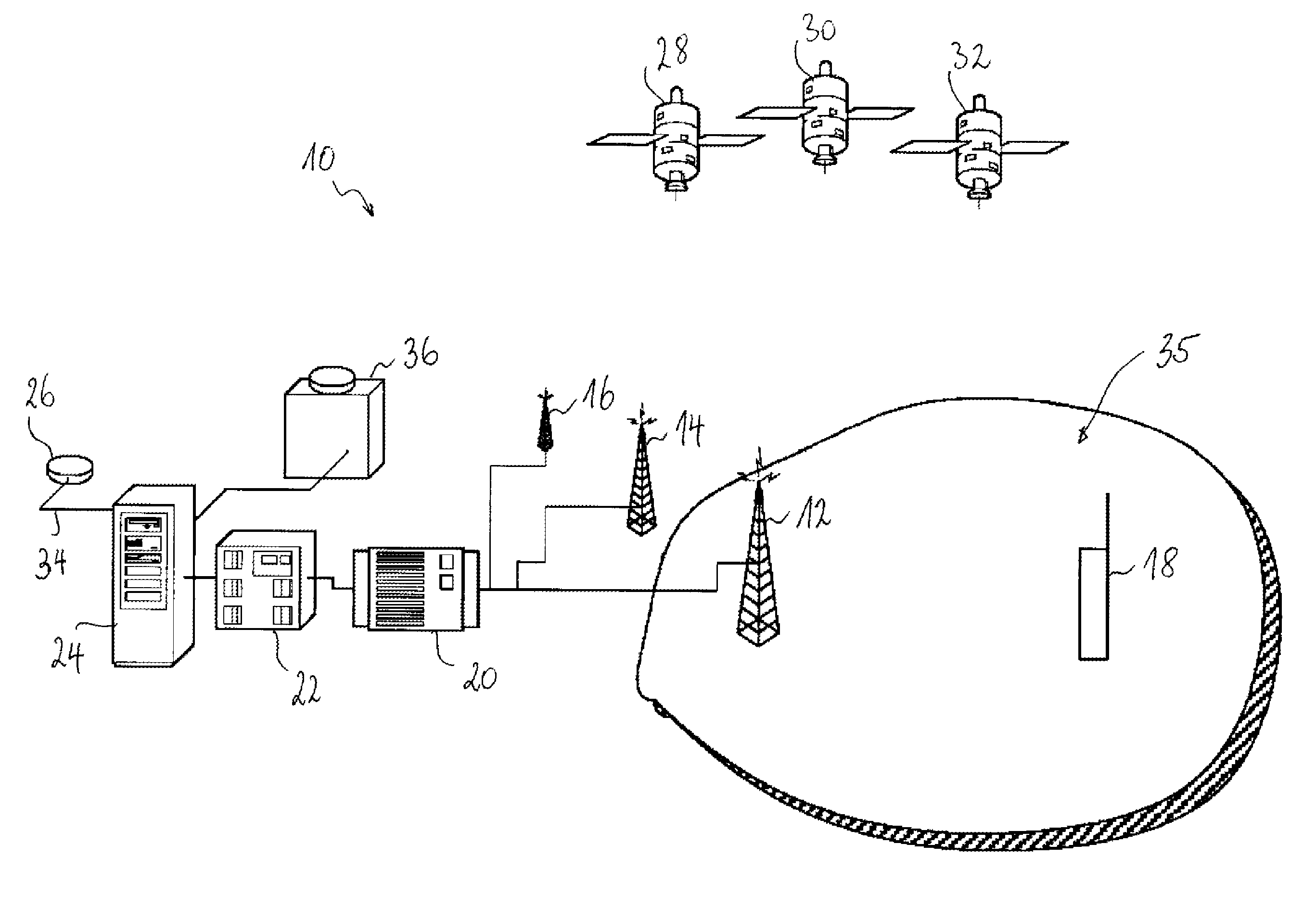
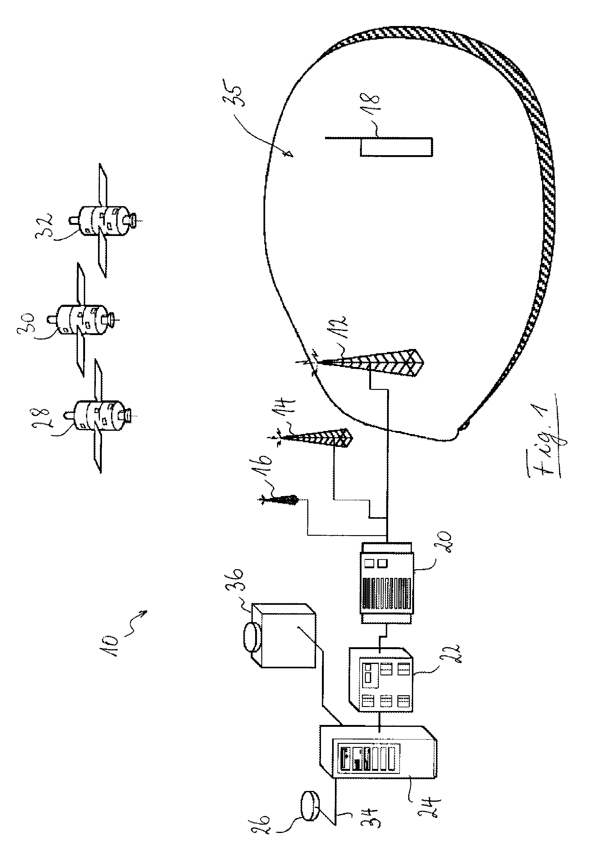
[0021]FIG. 1 shows the components of a communication system 10 using a satellite positioning system (such as e.g. GPS, GLONASS, Galileo or a combination thereof). The communication system 10 includes stationary infrastructure, such as the base transceiver stations 12, 14, 16 and a mobile station 18, e.g. the mobile phone shown in FIG. 1. The stationary infrastructure further includes a base station controller (BSC) 20, a serving mobile location centre (SLMC) 22 and an AGNSS server 24. The stationary infrastructure typically interfaces the mobile station 18 with land-based communication networks and / or the internet.

[0022]The AGNSS server is connected to a reference GNSS receiver 26, which receives ephemeris data broadcast by those GNSS satellites 28, 30, 32 that are visible from the location of the reference receiver 26. Communication between the reference receiver 26 and the AGNSS server 24 may be based on the internet protocol or any other suitable protocol. The server 24 receives ...


PUM


Abstract

“Satellites of a satellite positioning system broadcast within the navigation signals ephemeris data having a certain period of validity. At a mobile station, ephemeris data are required for position-fixing. In assisted satellite positioning systems, acquisition of navigation signals emitted by the satellites is facilitated as assistance data are provided to the mobile station. At a server station, a request for assistance data issued by the mobile station is received, and the server station transmits ephemeris data as part of the assistance data to the mobile station in response to its request. Upon receiving the request for assistance data issued by the mobile station, the server station decides whether the mobile station could achieve a specified position fix accuracy if the mobile station was provided with the broadcast ephemeris data. In the positive, the server station transmits the broadcast ephemeris data to the mobile station. In the negative, the server station transmits, instead of broadcast ephemeris data, long-term ephemeris data to the mobile station as part of the assistance data requested. The long-term ephemeris data are derived from satellite orbit predictions and have a period of validity substantially increased with respect to the ephemeris data broadcast by the satellites.”

Description

TECHNICAL FIELD[0001]The present invention generally relates to position fixing by means of a satellite positioning system, in particular to a method for providing a mobile station with assistance data that facilitate position fixing of the mobile station.BRIEF DESCRIPTION OF RELATED ART[0002]GNSS (Global Navigation Satellite System) receivers determine the range to satellites orbiting around the earth to determine their geographical location. If the ranges from the receiver to the satellites and the positions of the satellites are known, the location of the receiver can be computed. As the positions of the satellites change with time, the receiver needs a description of their orbits as a function of time. As a rule of thumb, one may assume that an error of 100 m on the satellite positions translates into an error of approximately 25 m on the location determined by the receiver. Each satellite therefore transmits ephemeris data as a description of its orbit within the broadcast sign...

Claims


Application Information

Patent Timeline
Patent Type & Authority Applications(United States)
IPC IPC(8): G01S5/14G01S19/05G01S19/25G01S19/27
CPCG01S19/05G01S19/27G01S19/258G01S5/14
Inventor CORAZZA, STEPHANEMONNERAT, MICHEL
Owner THE EURO UNION REPRESENTED BY THE EURO CO
Why Eureka
Try Eureka