GIS data editing method

A data editing and editing technology, applied in the field of geographic information, can solve the problems of difficult data editing and single interaction, and achieve the effect of improving data editing efficiency.

Active Publication Date: 2019-12-10
XIAN REMOTE SENSING SCI & TECH OF INFORMATION CO LTD
View PDF7 Cites 4 Cited by
  • Summary
  • Abstract
  • Description
  • Claims
  • Application Information

AI Technical Summary

Problems solved by technology

[0003] In view of the problems of difficult data editing and single interactive mode in the prior art, it is expected to provide a GIS data editing method

Method used


Image

  • GIS data editing method
  • GIS data editing method

Examples


Embodiment Construction

[0060] The application will be further described in detail below in conjunction with the accompanying drawings and embodiments. It should be understood that the specific embodiments described here are only used to explain related inventions, rather than to limit the invention. It should also be noted that, for ease of description, only parts related to the invention are shown in the drawings.

[0061] It should be noted that, in the case of no conflict, the embodiments in the present application and the features in the embodiments can be combined with each other. The present application will be described in detail below with reference to the accompanying drawings and embodiments.

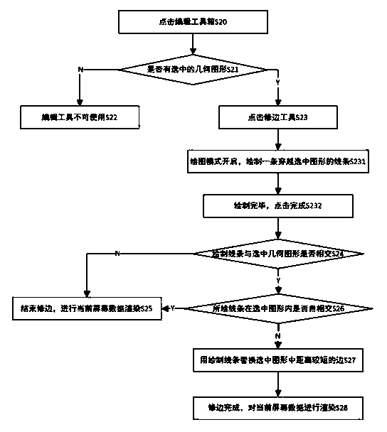
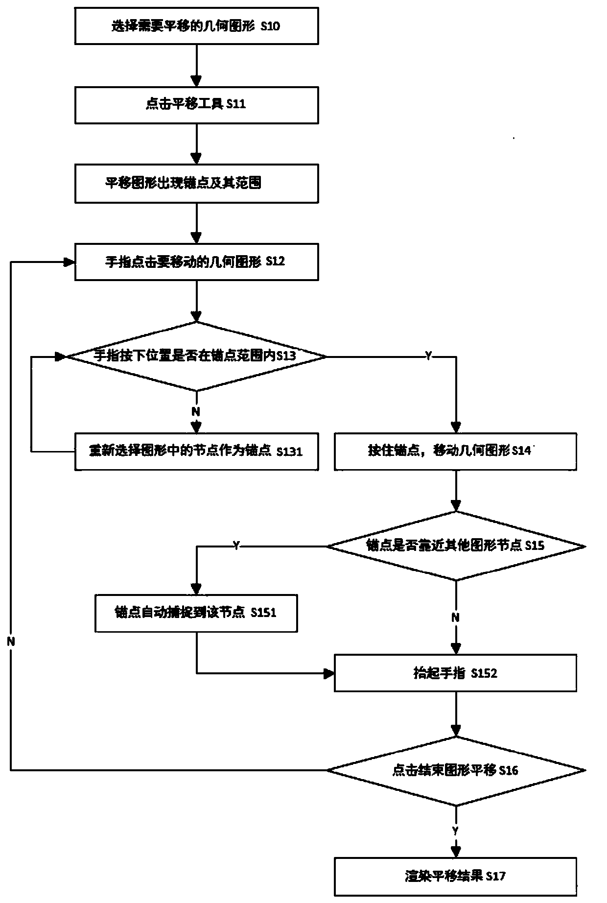
[0062] refer to Figure 1-2 , a GIS data editing method, which translates the graphics to be edited to a designated position, performs point adjustment, edge adjustment and surface processing operations on the translated graphics, and then completes the editing;

[0063] S10) Select the geometry ...


PUM


Abstract

The invention belongs to the technical field of geographic information methods and discloses a GIS data editing method which comprises the translation steps that a geometric figure needing translationis selected, an anchor point and an anchor point range are displayed after a translation tool is clicked, a finger clicks the geometric figure needing translation, and if the clicking position of thefinger is within the anchor point range, the anchor point is pressed, and a geometric object is moved; otherwise, nodes in the graph are reselected as anchor points, and the finger clicking positionis continuously judged until the finger clicking position is within the range of the anchor points. According to the method, surveyors can conveniently edit and correct drawn geometric figures on sitein field work, and the field work data editing efficiency is improved. According to the method, editing operation of point, line and surface graphic objects can be carried out through the functions of node movement, node addition, node deletion, trimming, line segmentation, surface segmentation, combination, public edge automatic tracking, cutting and the like.

Description

technical field [0001] The present invention generally relates to the technical field of geographic information methods, in particular to a GIS data editing method. Background technique [0002] With the continuous development of mobile geographic information method GIS, the GIS data rendering, collection and editing platform based on the large amount of mobile terminal data is often used in field data survey and collection work. For field data survey and collection, staff often need to carry remote sensing images and corresponding office data to the field for data collection and editing; when editing data, since the screens of existing handheld mobile GIS terminals are mostly small, the interactive mode It is relatively simple, and it is very difficult for field personnel to operate and edit GIS data on the screen with fingers; if a mobile GIS terminal with a single interactive mode or cannot provide a complete collection and editing process module is used, the efficiency o...

Claims


Application Information

Patent Timeline
Patent Type & Authority Applications(China)
IPC IPC(8): G06F3/0481G06T11/00G06T15/00
CPCG06F3/0481G06T11/00G06T15/00
Inventor 李崇贵
Owner XIAN REMOTE SENSING SCI & TECH OF INFORMATION CO LTD
Why Eureka
Try Eureka