
Shadow matching improved algorithm based on a Beidou GEO satellite

A technology for improving algorithms and satellites, which is applied in the field of satellite navigation and can solve problems such as poor satellite positioning and positioning accuracy.

Active Publication Date: 2019-12-17
GUILIN UNIV OF ELECTRONIC TECH
View PDF2 Cites 5 Cited by
  • Summary
  • Abstract
  • Description
  • Claims
  • Application Information

AI Technical Summary

Problems solved by technology

[0003] The purpose of the present invention is to provide an improved shadow matching algorithm based on the Beidou GEO satellite, aiming to solve the technical problem of poor positioning accuracy of satellite positioning in the "urban canyon" environment in the prior art

Method used


Image

  • Shadow matching improved algorithm based on a Beidou GEO satellite
  • Shadow matching improved algorithm based on a Beidou GEO satellite
  • Shadow matching improved algorithm based on a Beidou GEO satellite

Examples


Embodiment Construction

[0026] The embodiments of the present invention are described in detail below. Examples of the embodiments are shown in the accompanying drawings, in which the same or similar reference numerals indicate the same or similar elements or elements with the same or similar functions. The embodiments described below with reference to the accompanying drawings are exemplary, and are intended to explain the present invention, but should not be construed as limiting the present invention.

[0027] In the description of the present invention, it should be understood that the terms "length", "width", "upper", "lower", "front", "rear", "left", "right", "vertical", The orientation or positional relationship indicated by "horizontal", "top", "bottom", "inner", "outer", etc. is based on the orientation or positional relationship shown in the drawings, and is only for the convenience of describing the invention and simplifying the description, not It indicates or implies that the pointed device...


PUM


Abstract

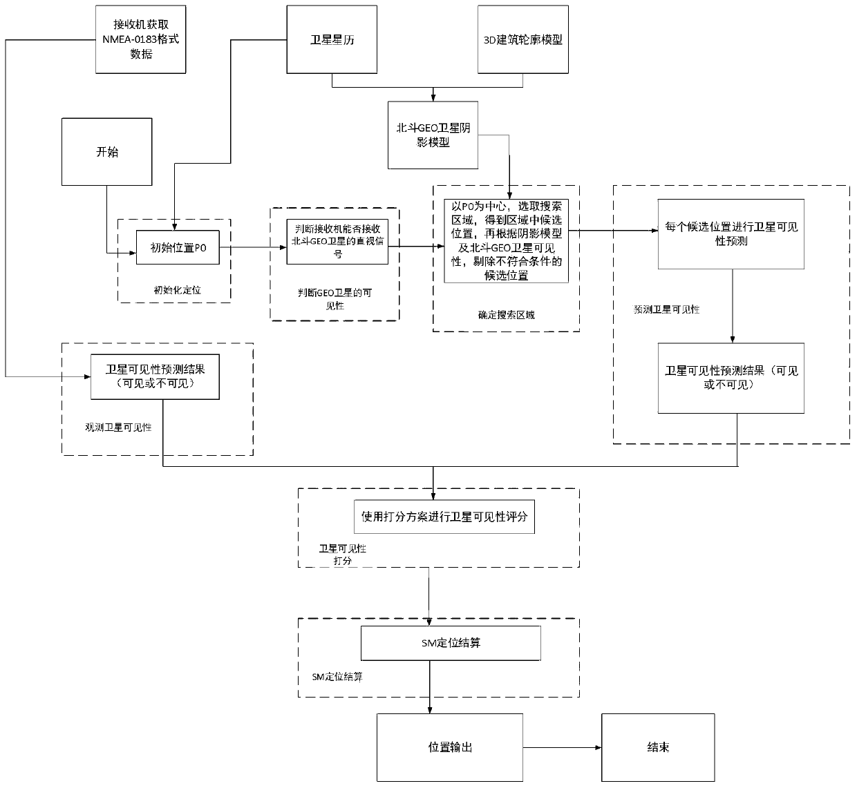
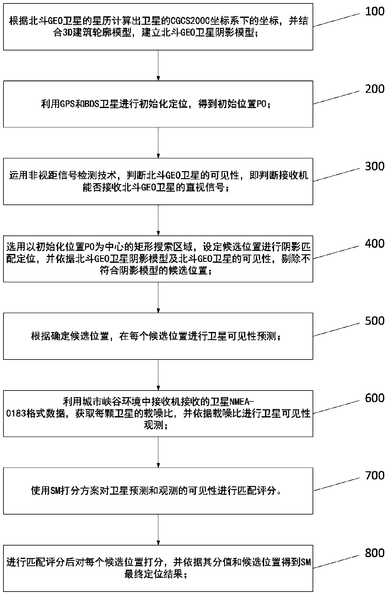
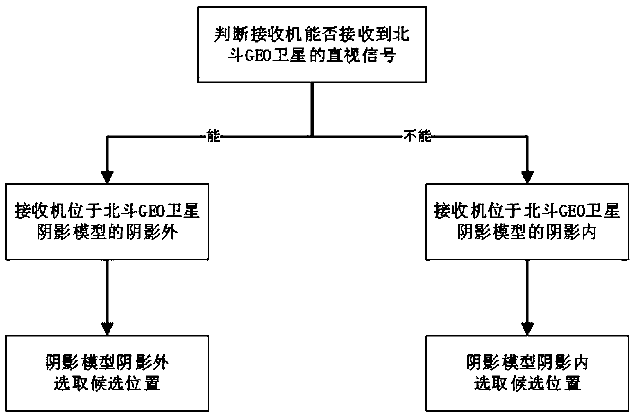
The invention discloses a shadow matching improved algorithm based on a Beidou GEO satellite, comprising the following steps: establishing a Beidou GEO satellite shadow model; performing initialization positioning by using a GPS and a BDS satellite to obtain an initial position P0; judging the visibility of the Beidou GEO satellite by using a non-line-of-sight signal detection technology; settingcandidate positions for shadow matching and positioning, and removing the candidate positions which do not accord with the shadow model; carrying out satellite visibility prediction at each candidateposition according to the determined candidate positions; acquiring the carrier-to-noise ratio of each satellite by utilizing satellite NMEA-0183 format data received by a receiver in an urban canyonenvironment, and performing satellite visibility observation according to the carrier-to-noise ratio; performing matching scoring on satellite prediction and observation visibility by using an SM scoring scheme; and scoring each candidate position after matching scoring, and obtaining an SM final positioning result according to the scores and the candidate positions. The positioning precision of satellite positioning in the urban canyon environment is improved.

Description

Technical field [0001] The invention relates to the field of satellite navigation, in particular to an improved algorithm for shadow matching based on the Beidou GEO satellite. Background technique [0002] With the continuous development of the Global Navigation Satellite System (GNSS), satellite positioning has become one of the most important means for people's daily positioning. However, in the "urban canyon" environment with dense tall buildings and short distances between tall buildings, due to the occlusion, reflection and diffraction of satellite signals by buildings, it will cause multipath interference, signal attenuation, non-line-of-sight signals (NLOS) to be received and geometric The factor of precision (GDOP) becomes larger, resulting in poor positioning accuracy. Summary of the invention [0003] The purpose of the present invention is to provide an improved algorithm for shadow matching based on Beidou GEO satellites, which aims to solve the technical problem of ...

Claims


Application Information

Patent Timeline
Patent Type & Authority Applications(China)
IPC IPC(8): G01S19/39
CPCG01S19/39Y02D30/70
Inventor 孙希延陶堃黄建华纪元法付文涛赵松克严素清符强王守华韦照川
Owner GUILIN UNIV OF ELECTRONIC TECH
Learn More