
Cooperative spectrum sensing method based on GEO and LEO double-layer satellite network

A technology of cooperative spectrum sensing and double-layer satellite network, which is applied in the field of cooperative spectrum sensing and wireless communication, can solve the problem of weak single-satellite sensing ability, achieve the effect of improving spectrum sensing performance and reducing the overall error rate

Active Publication Date: 2019-12-27
NANJING UNIV OF POSTS & TELECOMM +1
View PDF7 Cites 19 Cited by
  • Summary
  • Abstract
  • Description
  • Claims
  • Application Information

AI Technical Summary

Problems solved by technology

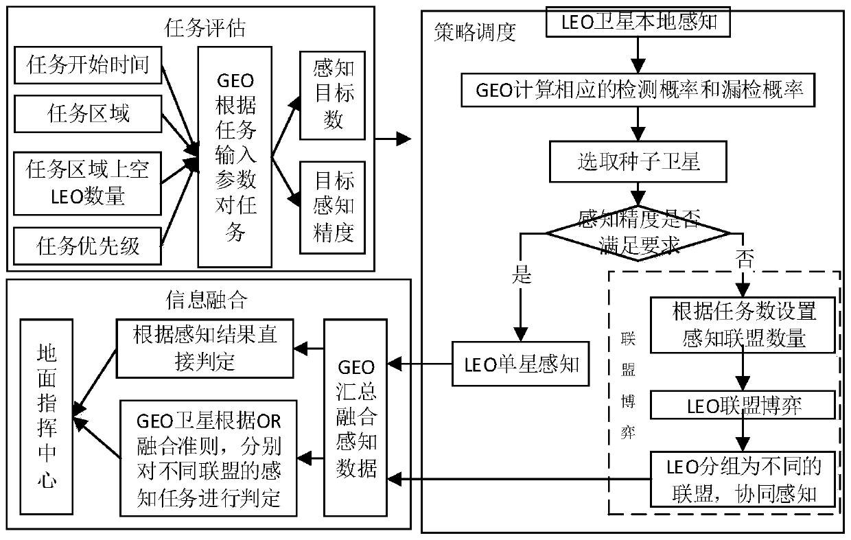
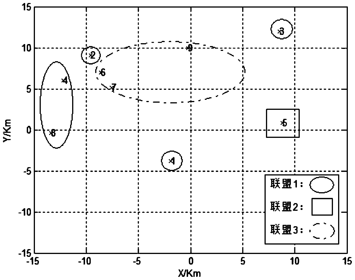
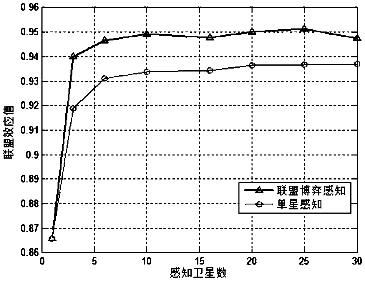
[0006] Purpose of the invention: Aiming at the problem of weak perception ability of LEO single satellite, the present invention provides a collaborative sensing method based on task-driven GEO and LEO double-layer satellite network, using GEO as the backbone node of the network to undertake task evaluation and implementation of collaborative algorithms, The LEO satellite senses the spectrum of the mission target according to the GEO command; in order to take into account the contradictory probability of missed detection and false alarm probability in the multi-satellite cooperative sensing, the present invention also proposes a multi-satellite cooperative algorithm based on the alliance game, and the number of mission targets As the number of divided alliances, LEO satellites form alliances to sense targets separately; the method of the present invention can improve spectrum sensing performance and reduce the overall error rate in spectrum detection

Method used


Image

  • Cooperative spectrum sensing method based on GEO and LEO double-layer satellite network
  • Cooperative spectrum sensing method based on GEO and LEO double-layer satellite network
  • Cooperative spectrum sensing method based on GEO and LEO double-layer satellite network

Examples


Embodiment Construction

[0040] The present invention will be further described below in conjunction with the accompanying drawings.

[0041]A collaborative spectrum sensing method based on the GEO and LEO double-layer satellite network. GEO satellites are used as the backbone nodes of the network to evaluate the sensing tasks and implement a multi-satellite cooperative sensing strategy; The method senses whether the ground equipment occupies spectrum resources (single-satellite spectrum sensing), and reports the sensing results to the GEO satellite. This method can reduce the burden of LEO satellites through centralized spectrum sensing, which meets the actual needs of miniaturization and light weight of LEO satellites. In addition, GEO satellites remain relatively stationary with the ground, have wide coverage, have good stability, and can quickly and accurately evaluate perception task. In addition, the multi-satellite sensing based on the alliance game can simultaneously sense multiple targets, a...


PUM


Abstract

The invention discloses a cooperative spectrum sensing method based on a GEO and LEO double-layer satellite network. The cooperative spectrum sensing method comprises three functional modules including a task evaluation module, a strategy scheduling module and an information fusion module. Firstly, in a task evaluation module, a GEO satellite evaluates an overall task according to task input parameters, and the area, the number and the sensing precision of sensing targets are determined; and then, in a strategy scheduling module, the GEO satellite selects a single-satellite spectrum sensing strategy and a multi-satellite cooperative sensing strategy according to whether the single-satellite sensing precision can meet the task evaluation requirement or not. And finally, in an information fusion stage, the GEO respectively summarizes the perception data of each alliance, and judges a plurality of task targets. According to the method, seed satellite selection and coalition game are combined, the task requirements of different levels can be met for multi-target cooperative sensing, the missed detection probability and the false alarm probability which are contradictory in multi-satellite cooperative sensing are considered, the overall error rate of the two probabilities is effectively reduced, and the spectrum sensing performance is improved.

Description

technical field [0001] The invention relates to a collaborative spectrum sensing method based on a GEO and LEO double-layer satellite network, which belongs to wireless communication technology. Background technique [0002] Low-orbit satellites have the characteristics of wide coverage, short satellite-to-earth distance, low communication delay, and small propagation loss, and the constellation composed of multiple low-orbit satellites can achieve global (including two poles) seamless coverage, which can effectively overcome ground communication networks. Insufficient in coverage, it has broad application prospects. In recent years, in-depth research on low-orbit satellites has been carried out at home and abroad, and some companies have even proposed large-scale constellation systems composed of hundreds or thousands of LEO satellites, such as SpaceX and OneWeb, which represent the future development direction of satellite communications. On the other hand, with the devel...

Claims


Application Information

Patent Timeline
Patent Type & Authority Applications(China)
IPC IPC(8): H04B7/185H04B17/382H04W16/14H04W72/04H04W72/10
CPCH04B7/18513H04B7/18519H04B17/382H04W16/14H04W72/0453H04W72/56
Inventor 丁晓进王运峰张更新洪涛
Owner NANJING UNIV OF POSTS & TELECOMM
Learn More