Robust ground subsidence monitoring method based on radar distributed target

A ground subsidence and distributed technology, which is applied in measuring devices, surveying and navigation, height/horizontal measurement, etc., can solve problems affecting computing efficiency and achieve robust, reliable and predictable algorithms

Pending Publication Date: 2020-02-07
INST OF GEODESY & GEOPHYSICS CHINESE ACADEMY OF SCI
View PDF4 Cites 11 Cited by
  • Summary
  • Abstract
  • Description
  • Claims
  • Application Information

AI Technical Summary

Problems solved by technology

[0005] However, SqueeSAR needs to iterate to solve the nonlinear optimal phase, which seriously affects the operation efficiency

Method used


Image

  • Robust ground subsidence monitoring method based on radar distributed target
  • Robust ground subsidence monitoring method based on radar distributed target
  • Robust ground subsidence monitoring method based on radar distributed target

Examples


Embodiment Construction

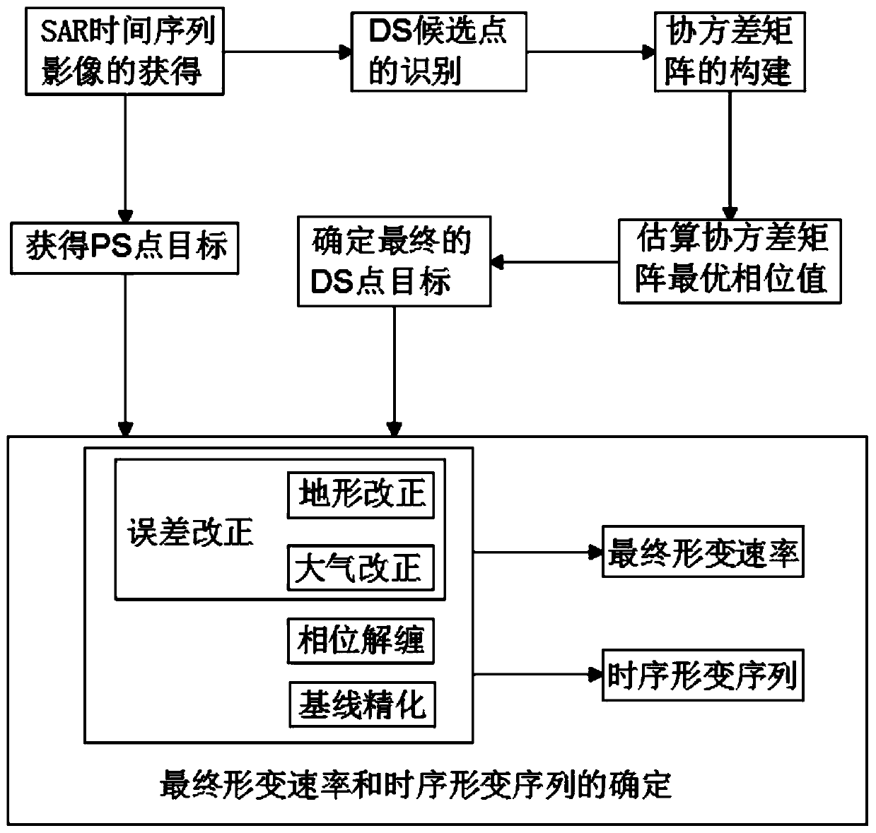
[0048] The following will clearly and completely describe the technical solutions in the embodiments of the present invention in conjunction with the accompanying drawings in the embodiments of the present invention. Obviously, the described embodiments are only some of the embodiments of the present invention, not all of them. The specific embodiments described here are only used to explain the present invention, not to limit the present invention. Based on the embodiments of the present invention, all other embodiments obtained by persons of ordinary skill in the art without creative efforts fall within the protection scope of the present invention.

[0049] see Figure 1-2 , the present invention provides a robust method for monitoring ground subsidence based on radar distributed targets, specifically comprising the following steps:

[0050] S1: Acquisition of SAR time-series images: use synthetic aperture radar to observe the ground all day and all-weather, obtain multipl...


PUM


Abstract

The invention discloses a robust ground subsidence monitoring method based on a radar distributed target. The method comprises a step of obtaining an SAR time sequence image, identifying DS candidatepoints, constructing a covariance matrix, estimating an optimal phase value of the covariance matrix, determining a final DS point target, obtaining a PS point target, and determining a final deformation rate and a time sequence deformation sequence, calculating and selecting an appropriate DS point target through a KS test method, establishing the covariance matrix to count interference phase andcoherence coefficient information, extracting a same distribution target and estimating related parameters, a step of estimating an optimal phase by extracting the phase of a feature vector corresponding to a maximum feature value from the established covariance matrix, a step of detecting the overall fitting degree of a regression equation according to the goodness of fit, wherein the overall fitting degree is used for determining the final DS point target, and a step of finally, performing sequential InSAR processing in combination with the PS point target. The ground subsidence can be better and accurately predicted, and the algorithm is stable and reliable.

Description

technical field [0001] The invention belongs to the technical field of urban geological disaster prediction, and in particular relates to a robust ground subsidence monitoring method based on radar distributed targets. Background technique [0002] Land subsidence is a geological phenomenon in which the surface elevation slowly decreases under the joint action of natural factors and human factors. It is a permanent loss of environment and resources that is difficult to compensate, and can induce a series of other environmental disasters. Its formation process is slow, which makes it difficult to be detected in a short period of time, and a small amount of subsidence requires precision instruments to be discovered, which is easy to be ignored by people. In many cases, land subsidence occurs in densely populated and industrially developed cities. extensive, serious damage, and the settlement process is irreversible. [0003] In recent years, the time-series InSAR method has a...

Claims


Application Information

Patent Timeline
Patent Type & Authority Applications(China)
IPC IPC(8): G01C5/00G01S17/90G06K9/00
CPCG01C5/00G06V20/13
Inventor 江利明孙奇石潘超
Owner INST OF GEODESY & GEOPHYSICS CHINESE ACADEMY OF SCI
Why Eureka
Try Eureka