Method for identifying drivable area of vehicle based on laser radar sensor

A driving area and lidar technology, applied in the field of intelligent vehicle environment perception, can solve the problems of too much point cloud data, poor accuracy, hidden dangers, etc., to ensure driving safety, improve real-time performance, and reduce the amount of calculation.

Active Publication Date: 2020-02-11
JILIN UNIV
View PDF5 Cites 17 Cited by
  • Summary
  • Abstract
  • Description
  • Claims
  • Application Information

AI Technical Summary

Problems solved by technology

[0005]1) Based on the camera sensor, the accuracy of the identified safe driving area in front of the vehicle is poor, and there is a large potential safety hazard
[0006]2) Based on high-performance lidar sensors, the on-board computing platform needs to process too much point cloud data, resulting in poor real-time performance and unable to meet the needs of smart cars
[0007]3) The identified safe driving area in front of the vehicle does not take into account the vehicle's own factors, resulting in some areas that vehicles cannot pass through being identified as safe driving areas, resulting in extreme big security risk

Method used


Image

  • Method for identifying drivable area of vehicle based on laser radar sensor
  • Method for identifying drivable area of vehicle based on laser radar sensor
  • Method for identifying drivable area of vehicle based on laser radar sensor

Examples


Embodiment Construction

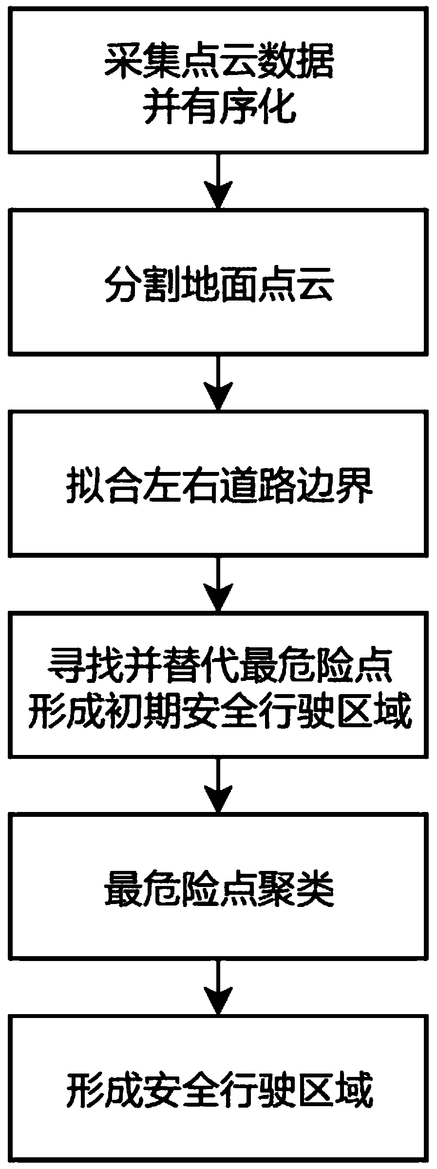
[0035] refer to figure 1 , the present invention provides a method for identifying the safe driving area of ​​a vehicle based on a laser radar sensor, which specifically includes collecting and ordering point cloud data, segmenting the ground point cloud, fitting the left and right road boundaries, and finding the most dangerous points to form an initial safety zone. There are six parts including the driving area, the repairing initial safe driving area, and the formation of the final safe driving area.

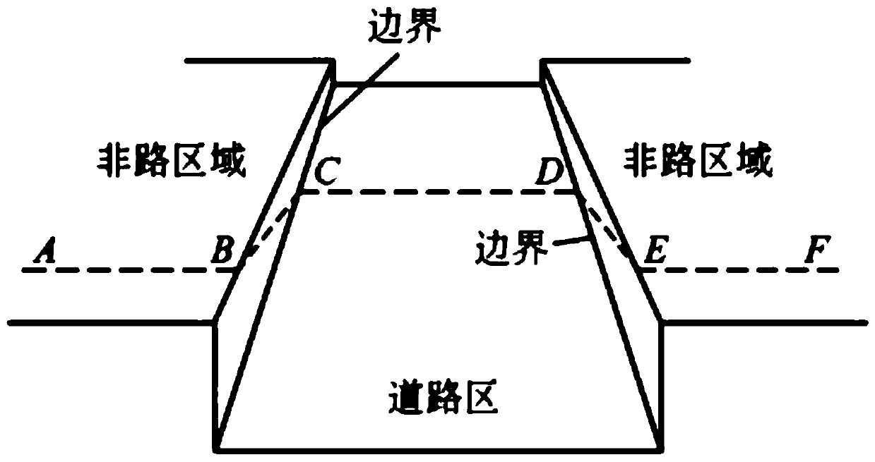
[0036] refer to figure 2 , this method is mainly applicable to structured roads, in which the road area CD is relatively flat, there is a height difference of 0.1-0.2m between the non-road area AB and EF area relative to the road area, and there is an obvious height difference between the boundary area BC and DE Jump. details as follows:

[0037] Step 1. Install the solid-state lidar at the front of the vehicle at a height of 0.4-0.5m from the ground. The installation pos...


PUM


Abstract

The invention belongs to the field of intelligent automobile environment perception, and particularly relates to a method for identifying a drivable area of a vehicle based on a laser radar sensor. The method specifically comprises the following six parts: collecting point cloud data and ordering, segmenting ground point cloud, fitting left and right road boundaries, finding the most dangerous point to form an initial safe driving area, repairing the initial safe driving area, and forming a final safe driving area. According to the method, the road boundary data are processed by adopting a rasterization thought, so that the weight occupied by abnormal points is effectively reduced, and fitting of a road boundary which better conforms to the reality is facilitated. A random sampling consistency algorithm is adopted to fit the road boundary, compared with a common least square method, the method removes the influence of noise points and abnormal points to the maximum extent, and fittingof the real road boundary is facilitated. The thought of the most dangerous point is applied, only point clouds which can cause dangers are concerned, hundreds of thousands of point cloud data are successfully simplified into hundreds of point clouds, the calculation amount is greatly reduced, and the real-time performance is remarkably improved.

Description

technical field [0001] The invention belongs to the field of environment perception of intelligent automobiles, in particular to a method for identifying a driving area of ​​a vehicle based on a laser radar sensor. Background technique [0002] With the rapid development of social science and technology and the continuous acceleration of China's urbanization process, the available physical space in the city has been continuously reduced, and various forms of transportation are facing increasingly severe challenges; due to the increase in the frequency and distance of residents' travel, In terms of safety, flexibility and reliability, new requirements have been put forward for my country's transportation capacity. In this context, smart cars have gradually become one of the hot technologies in the world, and it is currently in rapid development. Since the development of smart car technology, its basic framework includes environmental perception, vehicle underlying control, de...

Claims


Application Information

Patent Timeline
Patent Type & Authority Applications(China)
IPC IPC(8): G06K9/32G06K9/34G06K9/62G01S17/88G01S17/93
CPCG01S17/88G06V10/25G06V10/267G06F18/2321
Inventor 丁海涛侯泽州张建伟李鑫高加倍洪雨希张洋
Owner JILIN UNIV
Why Eureka
Try Eureka