Remote sensing image mangrove forest extraction method and system based on deep convolutional neural network

A remote sensing image and neural network technology, applied in the field of geographic information science, can solve the problems of time-consuming, labor-intensive and low-precision mangrove interpretation.

Active Publication Date: 2020-02-28
湖北地信科技集团股份有限公司
View PDF4 Cites 16 Cited by
  • Summary
  • Abstract
  • Description
  • Claims
  • Application Information

AI Technical Summary

Problems solved by technology

[0003] The technical problem to be solved by the present invention is to provide a method for automatic extraction of mangroves from remote sensing images based on deep convolutional

Method used


Image

  • Remote sensing image mangrove forest extraction method and system based on deep convolutional neural network

Examples


Embodiment Construction

[0007] In order to have a clearer understanding of the technical features, purposes and effects of the present invention, the specific implementation manners of the present invention will now be described in detail with reference to the accompanying drawings.

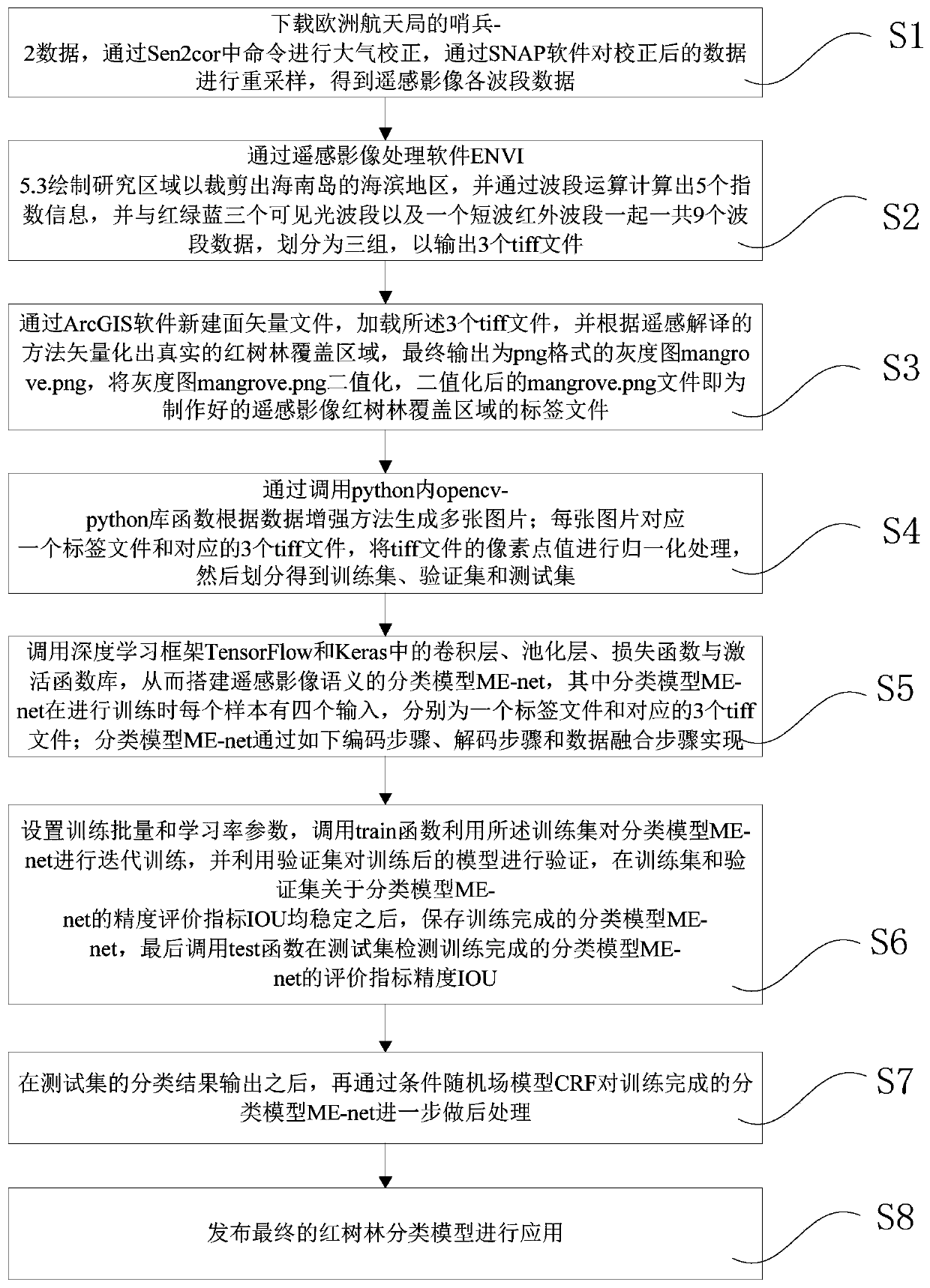
[0008] refer to figure 1 , figure 1 It is a flowchart of an embodiment of a remote sensing image mangrove extraction method based on a deep convolutional neural network. The remote sensing image mangrove extraction method based on deep convolutional neural network in this embodiment includes the following steps:

[0009] S1. Download the Sentinel-2 data (S2A MSIL1C) of the European Space Agency, open the CMD console, perform atmospheric correction through the command L2A_Process in Sen2cor, and resample the corrected data through the SNAP software (raster->geometric operations-> resampling) to obtain the data of each band of the remote sensing image.

[0010] S2. Use the remote sensing image processing software ENVI ...


PUM


Abstract

The invention discloses a remote sensing image mangrove forest extraction method and system based on a deep convolutional neural network, and the method comprises the steps: firstly carrying out the preprocessing of a high-resolution remote sensing image, including the atmospheric correction and research region cutting of the remote sensing image, and carrying out the waveband operation of each waveband after processing, so as to extract the priori feature information; achieving multi-band and feature information fusion by applying multi-source data fusion, and constructing a data set; training and verifying a semantic classification model ME-net built by a convolutional neural network; calling an ME-net model to realize automatic classification of the mangrove forest, and outputting a mask file in a png format, namely a classification and extraction result; and performing fine adjustment on the classification result through a long-distance conditional random field. In application of the classification model, the classification precision can reach 92.3% by expanding a data set, artificial visual interpretation can be completely replaced, and auxiliary technical support is providedfor updating of a high-precision image map and protection of a coastal region ecosystem.

Description

technical field [0001] The invention relates to the field of geographic information science, and more specifically, to a method and system for extracting mangroves from remote sensing images based on a deep convolutional neural network. Background technique [0002] In the update of high-precision image maps and the detection and protection of the ecological environment, the classification and interpretation of remote sensing images play a very important role. However, due to the complexity of remote sensing interpretation in practice, the interpretation process will It consumes a lot of manpower and material resources; at the same time, although there are many methods for the classification of ground objects in remote sensing images, the classification results are not good or bad. Among them, taking the extraction of mangroves in the coastal area as an example, it can be found that there are many difficulties. Among them, there are great differences and connections between ...

Claims


Application Information

Patent Timeline
IPC IPC(8): G06K9/00G06K9/62G06N3/04
CPCG06V20/188G06N3/045G06F18/24G06F18/214
Inventor 郭明强黄颖余仲阳李春风谢忠关庆锋吴亮王均浩曹威
Owner 湖北地信科技集团股份有限公司
Why Eureka
Try Eureka