Edge-enhanced multi-scale remote sensing image building semantic feature extraction method

A technology of remote sensing images and semantic features, applied in the field of building feature extraction, which can solve problems such as poor edge effect, incomplete building extraction, and incomplete details.

Pending Publication Date: 2020-03-17
NAT UNIV OF DEFENSE TECH
View PDF5 Cites 22 Cited by
  • Summary
  • Abstract
  • Description
  • Claims
  • Application Information

AI Technical Summary

Problems solved by technology

This method can effectively improve the problems of incomplete extraction of buildings of different scales in high-resolution remote sensing images such as satellites and UAVs, incomplete details, and poor edge ...

Method used


Image

  • Edge-enhanced multi-scale remote sensing image building semantic feature extraction method
  • Edge-enhanced multi-scale remote sensing image building semantic feature extraction method
  • Edge-enhanced multi-scale remote sensing image building semantic feature extraction method

Examples


Embodiment Construction

[0085] In order to facilitate the implementation of the present invention, further description will be given below in conjunction with specific examples.

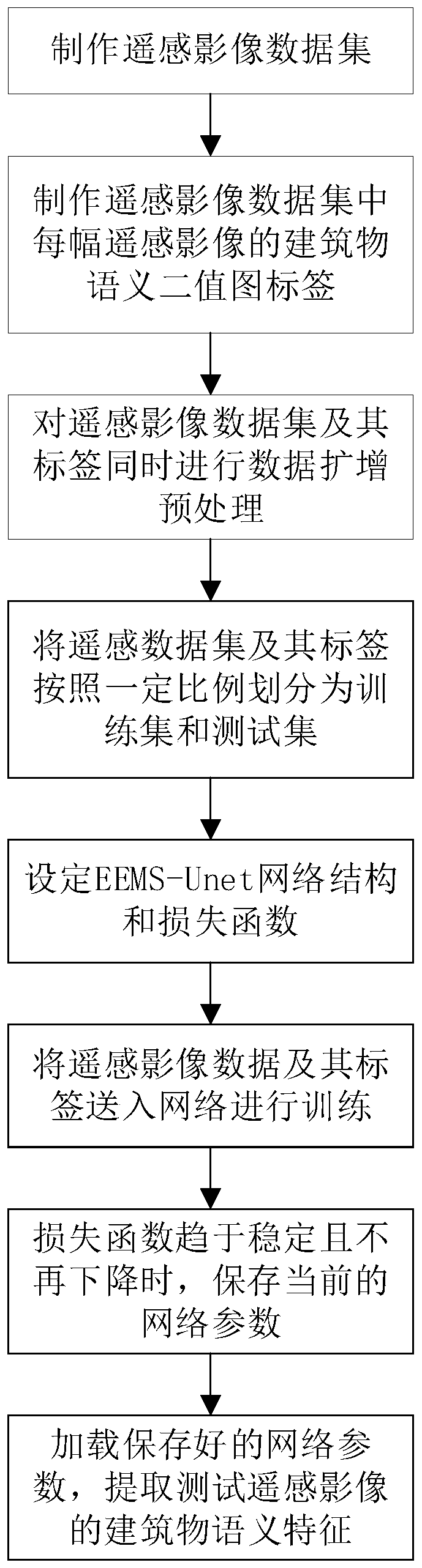
[0086] This embodiment provides an edge-enhanced, multi-scale remote sensing image building semantic feature extraction method, including: building remote sensing image data based on satellite remote sensing image data in existing geographic information systems and aerial photography devices to obtain a large number of remote sensing image data Set Images. The building semantic binary map label Masks corresponding to each remote sensing image in the remote sensing image dataset Images is obtained through the existing building vector data, geographic census data or manual labeling methods. The building pixels in the remote sensing image are in the binary map label. corresponds to 1, otherwise it is 0. Then, the remote sensing image dataset Images and its building semantic binary image label Mask are simultaneously subjected...


PUM


Abstract

The invention provides an edge-enhanced multi-scale remote sensing image building semantic feature extraction method. The method comprises the steps of obtaining a large amount of remote sensing imagedata to construct a remote sensing image data set Images, and obtaining a building semantic binary image label Masks, namely a real label, corresponding to each remote sensing image in the remote sensing image data set Images; constructing a building semantic extraction network EEMS-Unet model; training the building semantic extraction network EEMS-Unet model by utilizing the remote sensing imagedata set Images and the corresponding building semantic binary image label Masks to obtain the trained building semantic extraction network EEMS-Unet model; and inputting a remote sensing image to besubjected to building semantic feature extraction into the trained building semantic extraction network EEMS-Unet model, and extracting building semantic features in the remote sensing image to obtain a pixel-by-pixel prediction result Maskpred corresponding to the remote sensing image. According to the method, the problems of incomplete extraction, incomplete details and poor edge effect of buildings with different scales in high-resolution remote sensing images such as satellites and unmanned aerial vehicles can be effectively improved.

Description

technical field [0001] The invention belongs to the technical field of building feature extraction, and in particular relates to a method for extracting semantic features of buildings in remote sensing images. Background technique [0002] Remote sensing imaging technology is becoming more and more mature, and the resolution of remote sensing images is increasing day by day. People perceive the world from images and pay more attention to the advanced semantic features in images - roads, buildings, road signs, etc., and automatically, quickly and accurately extract semantics from remote sensing images. Features can help humans improve the efficiency of production and life. As an important place for human settlement activities, buildings are widely distributed and can well reflect the realities of human activities, production and living distribution, etc., and are of great significance in urban planning, resource census, disaster rescue, image positioning, etc. [0003] Since...

Claims


Application Information

Patent Timeline
IPC IPC(8): G06K9/62G06N3/04G06N3/08
CPCG06N3/08G06N3/045G06F18/214
Inventor 陈浩杜春徐樱笑伍江江彭双李军熊伟欧阳雪景宁陈荦钟志农吴烨王力伍送兵
Owner NAT UNIV OF DEFENSE TECH
Why Eureka
Try Eureka